Severe Storms Possible Tomorrow Night
FRIGID AIR: We begin this day below freezing over the northern half of the state with most communities reporting temperatures in the 20s right before sunrise. But, before you complain about the weather here… check out the early morning observation from Mount Washington, New Hampshire…
-35°F temperature + 70 mph winds = a current wind chill value of -86°F on #mountwashington. #mwo #NHwx #windchill #ArcticBlast pic.twitter.com/eaKIZX0iVl
— MWObservatory (@MWObs) December 16, 2016
We rise into the mid 50s this afternoon with a partly sunny sky; the sky becomes cloudy tonight.
WARM START TO THE WEEKEND: Tomorrow will be a cloudy, breezy, and very mild December day with a high in the low 70s. Some places will rise 50 degrees from the lows early this morning to highs tomorrow afternoon. Occasional rain showers are likely tomorrow, with the best rain coverage along and north of I-20 (Tuscaloosa to Birmingham to Anniston).
SEVERE STORMS POSSIBLE TOMORROW NIGHT: SPC maintains the standard “slight risk” of severe thunderstorms tomorrow night in the broad zone from Muscle Shoals to Livingston, with a “marginal risk” as far east as Birmingham…
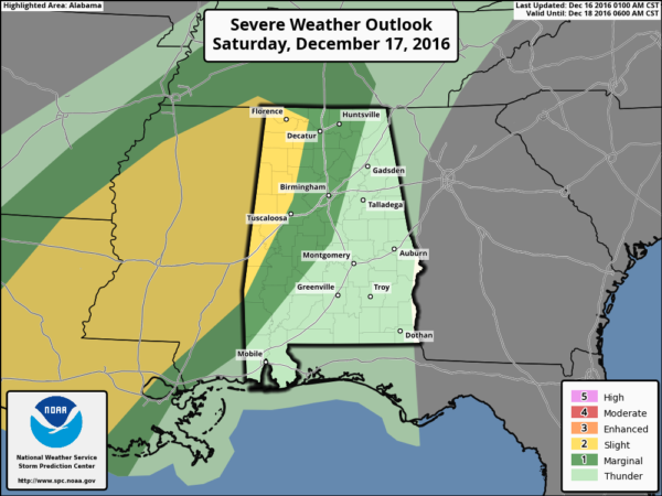
Dewpoints will surge into the mid 60s tomorrow night, helping to make the air unstable with surface based CAPE values rising to over 500 j/kg over West Alabama. With the approach of another Arctic front, this will bring the risk of strong to severe storms mainly west of I-65.
*Models are a bit faster, and we will now forecast the main window for severe storms to be from about 9:00 p.m. tomorrow through 3:00 a.m. Sunday.
*The main threat will come from strong straight line winds, but with the forecast helicity values, a few tornadoes will be possible as well over West Alabama.
*We do not expect any severe weather over East Alabama.
*Rain amounts of 1-2 inches are likely by Sunday.
Just be sure you have a good way of hearing severe weather warnings tomorrow night if they are needed… like a NOAA Weather Radio, or a good smart phone warning app like WeatherRadio by WDT.
MORE ARCTIC AIR SUNDAY: The high resolution NAM has the surface front south of Birmingham at 6:00 Sunday morning… from near Wedowee to Prattville to Monroeville…
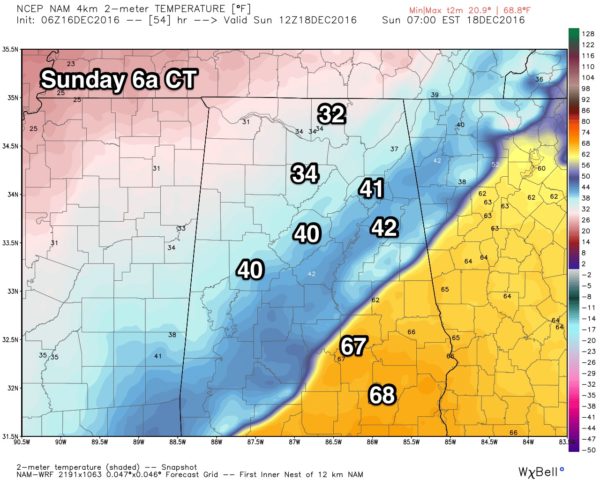
Temperatures will drop into the 30s early Sunday, and stay there pretty much all day. Rain will end from northwest to southeast during the midday hours, and there is still some chance there could be a touch of sleet or freezing rain as the precipitation winds down over North Alabama, but if that happens we expect no impact. It will be a very cold, wet, raw day.
NEXT WEEK: Dry weather is the story Monday through Wednesday with a slow warming trend; rain should return toward the end of the week, but forecast confidence is low based on model inconsistency.
CHRISTMAS WEEKEND: The latest global model data suggests it will be dry with seasonal temperatures (highs upper 50s) around here, but it is simply too early to be confident in a specific forecast. If you are looking for “White Christmas”… head north.
ON THIS DATE IN 2000: An EF4 tornado tore through the southern part of Tuscaloosa, killing eleven people and injuring over 100. Nine of the fatalities occurred in mobile homes, one in a vehicle, and one in a commercial building converted to residential use. Six of those killed were females and five were males. Ages ranged from 16 months to 83 years old. The tornado was on the ground for a total of 18 miles, all within Tuscaloosa county. The tornado path was estimated to be 750 yards wide at it’s maximum intensity.
There was an excellent warning for the tornado; a warning was issued at 12:40 p.m. on that deadly Saturday, 14 minutes before the twister first touched down in a rural area southwest of Tuscaloosa near the Black Warrior River. The tornado crossed Alabama 69 near Shelton State Community College and Hillcrest High School; destroying a shopping center and many homes. The Bear Creek Trailer Park was hit, where many of the deaths occurred. The tornado moved to the east/northeast, south of Skyland Boulevard, and finally crossed I-59/20 near the Cottondale exit.
WEATHER BRAINS: Don’t forget you can listen to our weekly 90 minute netcast anytime on the web, or on iTunes. This is the show all about weather featuring many familiar voices, including our meteorologists here at ABC 33/40.
CONNECT: You can find me on all of the major social networks…
Facebook
Twitter
Google Plus
Instagram
Look for the next Weather Xtreme video here by 4:00 this afternoon… enjoy the day!
Category: Alabama's Weather
About the Author (Author Profile)
James Spann is one of the most recognized and trusted television meteorologists in the industry. He holds the AMS CCM designation and television seals from the AMS and NWA. He is a past winner of the Broadcast Meteorologist of the Year from both professional organizations.Subscribe
If you enjoyed this article, subscribe to receive more just like it.


