

A Beautiful Christmas Eve Eve Across Central Alabama At Midday

Skies are sunny across just about the entire Central Alabama area at the 11 o’clock hour, except for a few clouds over Marion, Fayette, and Lamar counties. This is allowing for a good supply of sunshine to reach the surface and temperatures are rising nicely at this time. The closest rain activity to the area at this time can be found in southern parts of Missouri, Illinois, and Indiana, with it changing over to snow to the northwest of that.
Skies will be partly to mostly clear for the afternoon, with highs reaching the low to mid 60s throughout the area. Clouds will start to build during the late afternoon and throughout the evening and overnight hours, as a system will be approaching the state. Ridging associated with a high centered over the Gulf Coast will keep most of Central Alabama dry, with chances of rain being best in the northwestern parts of the area near Hamilton and Haleyville. Overnight lows will be in the upper 40s to the mid 50s across the area.

Current Temperatures Across Central Alabama
Temperatures across Central Alabama are currently ranging from the mid 50s in the north, to the mid 60s in the south. The warm spot at this time is Troy at 64 degrees, with the cool spot belonging Gadsden and Cullman at 54 degrees.
Birmingham’s Climatology And Records
The normal high for December 23rd is 54, while the normal low is 34. The record high for today was set back in 1970 at 72 degrees. The record low was set back in 1989 at 1 degree.
What To Expect For Christmas Eve
It will be a warmer day across Central Alabama, as warm air advection will occur ahead of a surface front. That warm air advection will also bring a more humid airmass into the area. Skies will be mostly cloudy, but the ridging will keep most of the rain activity north of Central Alabama. There is a very small risk for showers as far south as Birmingham, but if any rain falls in the area will be confined to the extreme northern parts of the area. Afternoon highs will be in the mid 60s to the mid 70s across the area from north to south. Skies will be cloudy and all shower activity will be north of the Central Alabama area, so the evening and overnight hours will be dry. Temperatures will be mild, with lows only dropping to the low to mid 50s.
What To Expect For Christmas Day
What a Christmas Day for those who like warm temperatures. Skies will be partly cloudy and afternoon highs will be in the low to mid 70s across the area from north to south. Clouds will start to build for the evening and overnight hours, but no rain is expected. Lows will be in the mid 50s to near or at 60 degrees. Sorry, no white Christmas again this year. I guess that I’ll have to wait another year.
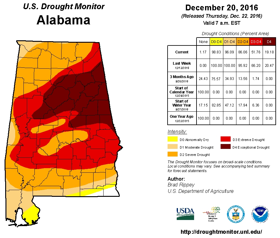
Latest On The Drought Situation
As of Thursday’s release of the U.S. Drought Monitor for Alabama, over 98% of the state remains in drought conditions, which is actually an improvement from last week when the entire state was classified in a drought. Over 86% of the state remains in severe drought conditions, with over 51% of the state in extreme or exceptional drought conditions. Believe it or now, less than 2% of the state was in an extreme drought just three months ago.
National & World Weather Extremes
McAllen, Texas recorded the warmest high temperature for Thursday across the U.S. at 85 degrees. West Yellowstone, Montana recorded the coldest low temperature in the U.S. for last night into the early morning hours today at -27 degrees.
Around the globe, the warmest temperature for Wednesday was recorded in Big Bend, Swaziland in the southern part of Africa at 115 degrees. The coldest temperature was recorded in Summit, Greenland at -65 degrees. The highest rain total from around the globe on Thursday was recorded in Paradisi, Greece at 11.93 inches.
On This Day In Weather History: 1983
The temperature plunged to 50 degrees below zero at Williston ND to equal their all-time record. Minneapolis MN reported an afternoon high of 17 degrees below zero, and that evening strong northerly winds produced wind chill readings of 100 degrees below zero in North Dakota.
Follow The Blog On Social Media
The blog is now on Facebook, so be sure to head over there, click the like and follow buttons to stay up-to-date with the latest info from your favorite meteorologists. Also, be sure to follow the Alabama Wx Weather Blog on Twitter. Just click here to start following our feed.
WeatherBrains
This is the weekly netcast that’s all about weather featuring many familiar voices, including our meteorologists at ABC 33/40. You can listen anytime on the web, or on iTunes. You can find it here.
Forecaster: Scott Martin (Twitter: @scottmartinwx)
Category: Alabama's Weather
About the Author (Author Profile)
Scott Martin is an operational meteorologist, professional graphic artist, musician, husband, and father. Not only is Scott a member of the National Weather Association, but he is also the Central Alabama Chapter of the NWA president. Scott is also the co-founder of Racecast Weather, which provides forecasts for many racing series across the USA. He also supplies forecasts for the BassMaster Elite Series events including the BassMaster Classic.Subscribe
If you enjoyed this article, subscribe to receive more just like it.


