

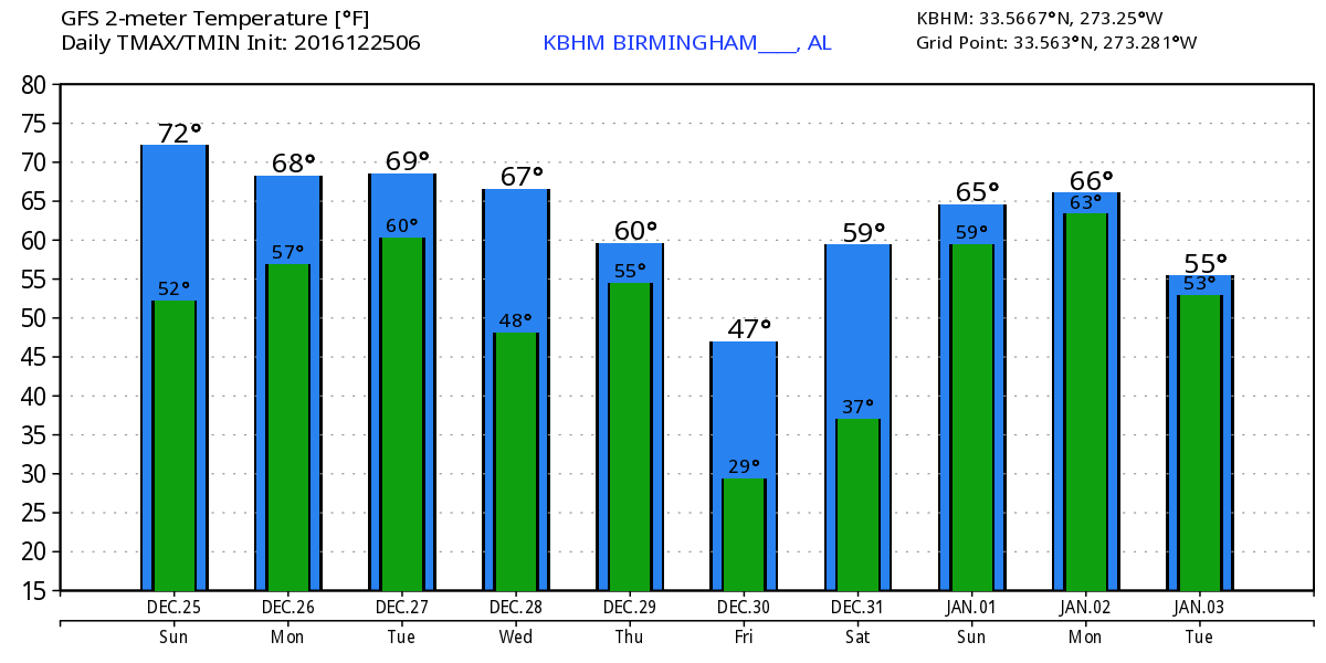
Very Mild Christmas Day
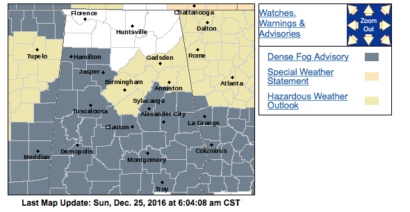
Much of Central Alabama with the exception of the Tennessee River Valley and the northeast quadrant of the state are waking up to some dense fog. A dense fog advisory is in effect until 9 am this Christmas morning. Once the fog burns off, look for a mixture of sun and clouds with highs in the lower and middle 70s.
And the beach weather looks good, too. I expect partly sunny days, and cool, fair nights, along the beaches through the end of year with the occasional passing shower or storm, from Gulf Shores to Panama City Beach. See the complete Gulf Coast 7 Day Planner here.
Here’s a quick summary of the record highs for Central Alabama for the next several days. Anniston and Birmingham could tie or set new records today. Monday the record highs are actually the lowest, so some new records are possible though clouds and some approaching showers may keep that from happening.
City          25th     26th     27th
Birmingham  77/2015  72/1911  74/1982
Tuscaloosa  78/1987  72/1984  78/1982
Anniston    73/1982  71/1964  75/1982
While the weather is rather nice across the Southeast US, a major storm system is wreaking havoc on travel across the mid section of the country. Numerous watches, warning, and advisories for winter weather are in effect – see the graphic below.

Clouds will be thickening up overnight tonight and into Monday ahead of the frontal system that will be dragging into the Southeast US late Monday and Tuesday. Southerly flow increases dramatically over the next 36 hours, so it looks like the best rain chances will come on Tuesday. Chances are better across the northern third of Alabama as the frontal system will be slowly degrading as it moves into the Southeast US. The main storm system is well to our north with the surface low moving across the southeast portion of Canada.
Late Tuesday and Wednesday the upper flow will go nearly zonal allowing us to dry out with temperatures plunging into really cold values. We should see highs drop back Tuesday and Wednesday into the 60s. But by Thursday midday we should see a strong trough dig into the eastern US once again. This will bring a fast moving front into the Southeast US again. The real problem for us is the lack of time for moisture to recover enough to provide us with a good rain event. It looks like the lack of moisture and the fast moving character of this front that rain chances will once again be somewhat limited. I feel pretty confident that there will be showers about, but no everyone is going to see rain at their location. Rainfall amounts for the first event Tuesday and this event are likely to remain low with less than a half inch possible and many locations receiving less than a quarter of an inch.
The upper trough dig into the East Coast Friday, so Friday and Saturday will be rather chilly days as lows once again drop to and below the freezing mark with highs mainly in the 50s.
Ridging occurs late Saturday and into Sunday, but a rather low altitude closed low begins moving out of the Southwest US on Sunday promising to ramp up rain chances as it taps into Pacific moisture. This is verging on voodoo country, so timing may be adjusted slightly in future runs, but this pattern holds the promise for a couple of wet days as we start 2017.
Looking further into voodoo country, the upper pattern goes zonal around the 5th of January suggesting an absence of any really cold weather as we stay fairly mild and seasonal. A strong trough moving through the Great Lakes around the 7th could bring an cold front into the Southeast US and perhaps a round of rain and storms. But by 372 hours the upper flow goes zonal again suggesting mild and dry weather for the 9th of January.
Just a reminder that James Spann is on vacation so we will be on a one-a-day schedule with the Weather Xtreme Videos until he returns on January 2nd. 2016 has been quite a year, and I really hope that you and your families will be able to enjoy the joy of this season – Merry Christmas. I expect to have the next video posted by 7 am or so on Monday. Godspeed.
-Brian-
Category: Alabama's Weather
About the Author (Author Profile)
Brian Peters is one of the television meteorologists at ABC3340 in Birmingham and a retired NWS Warning Coordination Meteorologist. He handles the weekend Weather Xtreme Videos and forecast discussion and is the Webmaster for the popular WeatherBrains podcast.Subscribe
If you enjoyed this article, subscribe to receive more just like it.


