

A Round of Showers Today
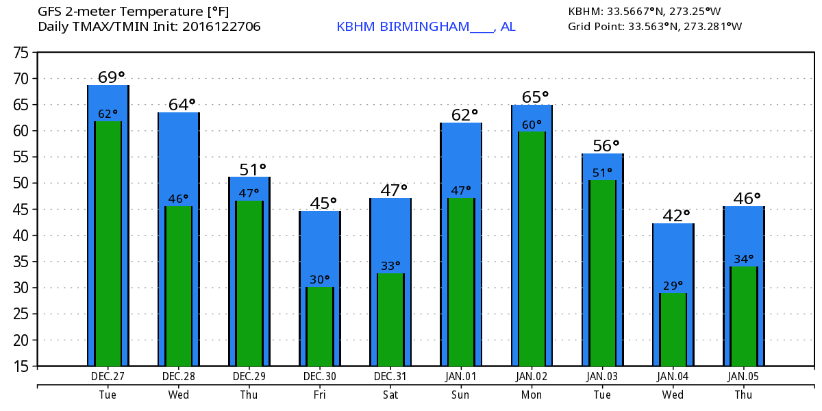
The cold front has arrived this morning stretching from about Knoxville to Jackson, MS, and into Southeast Texas. The wind has come around to the northwest at Muscle Shoals. Radar showed a line of scattered showers with a thunderstorm or two showing up, so there is enough instability for a few peals of thunder. Dense fog advisories were posted across a large section of Georgia and the southeast sections of Alabama as well as the Gulf Coast all the way into South Texas. The front is going to become parallel to the upper flow later today as most of the really good dynamics are well north of us with the surface low in Southeast Canada. Temperature forecasting today will be kind of tricky since how warm you get will depend heavily on the location of the front. Much of the western half of Central Alabama should see highs in the upper 60s while it will be a little warmer for East Central and South Alabama locations.

If you have plans that include a trip to the beach, you’ll find partly sunny days, and cool, fair nights, along the beaches through the end of year with an occasional passing shower or storm. Highs will be in the lower 70s until midweek then drop into the 50s. Morning lows will be in the 60s dropping into the 40s for the last few days of 2016. See the complete Gulf Coast 7-Day Planner here.
SPC for the next three days has no severe weather risk areas. Thunder will remain a possibility across much of the Southeast US and Gulf Coast through Thursday.
The upper flow will go zonal later today and for much of Wednesday. This will result in a slight cool down with highs in the 60s. By midday Wednesday we will be watching closely as an upper trough begins to dig into the eastern half of the country. This digging trough will bring a fast moving front through the Southeast during the first half of the day Thursday. The GFS has increased the speed of this front, so it now appears that the best chances for rain will come between about 10 pm Wednesday and 10 am on Thursday. This is certainly good news for the Birmingham Bowl which will be played at 1 pm on Thursday, so the rain should be over with the possibility of seeing some clearing to the sky. Due to the slightly faster movement of the front, temperatures will be a little cooler with highs in the 55 to 58 degree range.
The upper flow will go from northwesterly on Friday to nearly zonal on Saturday, so look for both days to be somewhat chilly with lows around 30 and highs in the lower 50s.
Rainfall with both of these first two systems will be spotty due to the character of showers. Places that do get wet are most likely to see rainfall amounts in the range of one quarter to three quarters of an inch. The better rain amounts should be over the Tennessee River Valley.
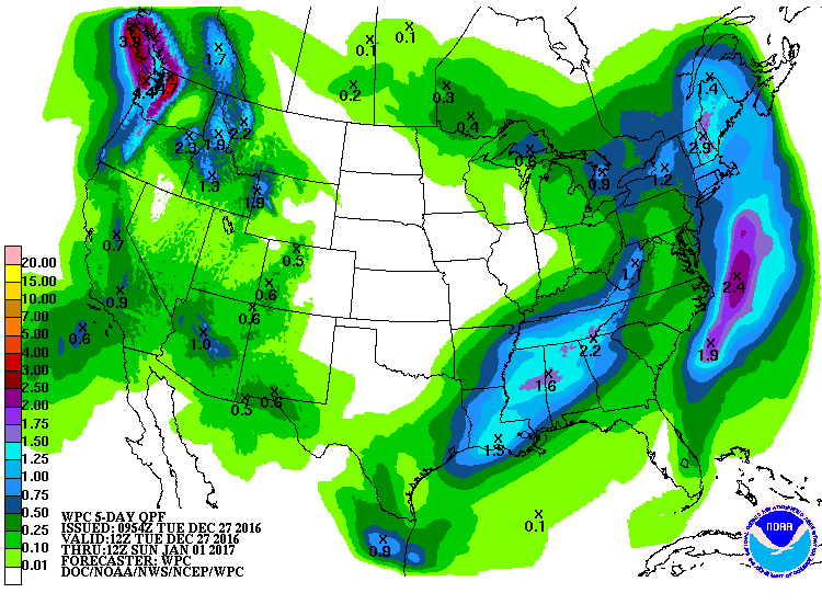
From Saturday into Sunday the upper flow affecting the Southeast US will go from zonal to southwesterly allowing for moisture out of the Pacific to make its way into our area. A series of weak disturbances moving through the flow promise to bring a soaking rain situation to the Southeast US. Still some question of when it will start, but the latest GFS run suggests clouds increase rapidly on Saturday, December 31st, with rain potentially beginning in western counties of Alabama during the afternoon. Once rain begins, rain is likely to continue off and on into the latter part of Monday. Rainfall with this system could reach amounts of 1 to almost 3 inches, just what we need to help with the drought conditions. This does verge into voodoo country, so we may need to adjust the timing on this, but it sure looks promising for 2017 to start on a wet note.
Looking into week 2 or voodoo country, the GFS maintains a rather fast flow with a series of weak short waves moving through that fast flow. One comes across the mid Mississippi River Valley around the 5th, another around the 7th, and yet another around the 11th. But while we see this active pattern of short waves, the overall character of the flow aloft is practically zonal. This means an absence of any extreme cold shots with relatively mild temperatures for the start of 2017.
I plan to post the next Weather Xtreme Video here by 7:30 am or so on Wednesday. Remember, you can always check back here for notes just about anytime on the Alabama weather pattern. Have a great day, hoping you get some rain at your location. Godspeed.
-Brian-
Category: Alabama's Weather
About the Author (Author Profile)
Brian Peters is one of the television meteorologists at ABC3340 in Birmingham and a retired NWS Warning Coordination Meteorologist. He handles the weekend Weather Xtreme Videos and forecast discussion and is the Webmaster for the popular WeatherBrains podcast.Subscribe
If you enjoyed this article, subscribe to receive more just like it.


