Chilly Today Becoming Wet Late Saturday
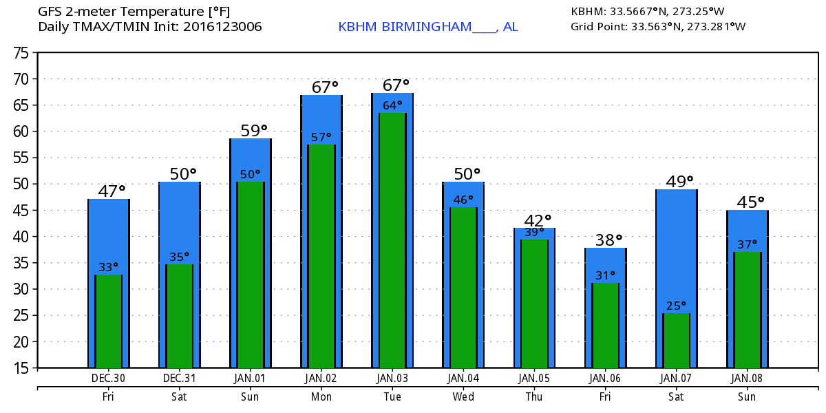
Clear skies prevail across the northern two-thirds of Alabama this morning with the day expected to be mostly sunny but chilly. Morning temperatures are starting out mainly in the 30s across North and Central Alabama. Even with the sunshine today highs will struggle to reach the 50-degree mark. But warmer and wetter weather is on tap for Central Alabama.
Headed to the beach? Sunny skies and breezy conditions are expected along the Alabama and Florida Panhandle beaches today with highs in the upper 50s. Clouds return along with multiple chances of rain for the weekend and into the start of next week. Highs Saturday will warm into the 60s then into the 70s of Sunday and beyond. See the complete Gulf Coast 7-Day Planner here.
For football enthusiasts, Alabama is in Atlanta for the Peach Bowl against the Washington Huskies with a Saturday afternoon 2:00 pm kickoff inside the Georgia Dome. The day looks cloudy with rain expected to move into North Georgia during the evening hours on Saturday. The high will be near 50 in Downtown Atlanta.
Auburn is heading to New Orleans for the Sugar Bowl against the Oklahoma Sooners for a 7:30 pm kickoff inside the Super Dome on Monday, January 2. The weather looks rather wet and unsettled down in the Big Easy, with showers and thunderstorms likely, and temperatures in the middle 70s.
Both of these football games will be held inside domed stadiums, so weather will not impact either game.
With a surface high settling in across the Southeast US, Saturday morning will be chilly again with temperatures falling into the range of 27 to 32. Clouds will be on the increase beginning before sunrise on Saturday as moisture increases with a southwesterly flow aloft tapping into Pacific moisture with the digging in of a strong closed low over Baja California. Rain will become likely by Saturday afternoon across much of Central Alabama. There remains some question as to whether or not we will see some light sleet with the initial onset of precipitation in the morning and early afternoon. The atmospheric profile shows moistening from the top down leaving some space for evaporative cooling to chill down the lowest portion of the atmosphere. This profile would support the presence of light sleet as precipitation begins, but with the atmosphere forecast to warm up fairly quickly, it does not appear likely that the sleet would create any kind of travel issues for North or Central Alabama.
The moist southwesterly flow will stay with us from late Saturday through Sunday and Monday. Rain will occur off and on with the potential for rainfall amounts to reach the 2 to 4 inch range with the heaviest amounts likely to fall across the southwest quadrant of Alabama. A strong short wave comes out of the Southwest US on Monday with the development of a strong surface low in eastern Colorado. This may set the stage for a round of strong to severe storms on Monday as CAPE values rise into the range of 1,000 to 1,400 j/kg with helicity values in the 200 to 400 range. It’s too early to be specific about the severe weather threat, and SPC has not outlined any specific area with just a casual reference to low probability factors. Temperatures will be mild with highs primarily in the 60s.
The surface low rolls quickly into the Great Lakes on Tuesday with a front moving across the Southeast US. This will bring an end to the rainy period and drop our temperatures back somewhat. Highs Wednesday and Thursday should be in the 50s.
For the end of the week the GFS is presenting a challenge with a threat for wintery precipitation across northern sections of the Southeast US. As southwesterly flow increases moisture once again on Thursday and Friday, a surface high to our northwest will bring colder air southward. The GFS is signaling a narrow band of wintery precipitation possible across North Alabama. This is the classic situation of the cold air arriving as the moisture is leaving. If this scenario develops – and often times they don’t simply because the timing has to be pretty exact – it looks like any winter weather would be short lived and not likely to produce any serious issues for travel. So there is no need to rush out and get milk and bread, but we will continue to keep a close eye on the situation with later model runs.
Looking out into voodoo country, the GFS maintains a practically zonal flow across the southern tier of the US out to the 12th of January. From the 12th of January to the end of the period around the 14th, an upper ridge develops over the East Coast of the US while a strong trough develops over the Rockies. This pattern could result in a strong surface system in the Central Plains states. But there is not a great deal of confidence out this far since we’ve been seeing the GFS bounce back and forth between zonal flow and a parade of short waves.
I expect to post the next Weather Xtreme Video here between 7 and 7:30 am Saturday. Check back here often for updates on the Alabama weather situation. Have a great day, stay warm, and Godspeed.
-Brian-
Category: Alabama's Weather
About the Author (Author Profile)
Brian Peters is one of the television meteorologists at ABC3340 in Birmingham and a retired NWS Warning Coordination Meteorologist. He handles the weekend Weather Xtreme Videos and forecast discussion and is the Webmaster for the popular WeatherBrains podcast.Subscribe
If you enjoyed this article, subscribe to receive more just like it.


