Wet and Stormy Weather for Start of 2017
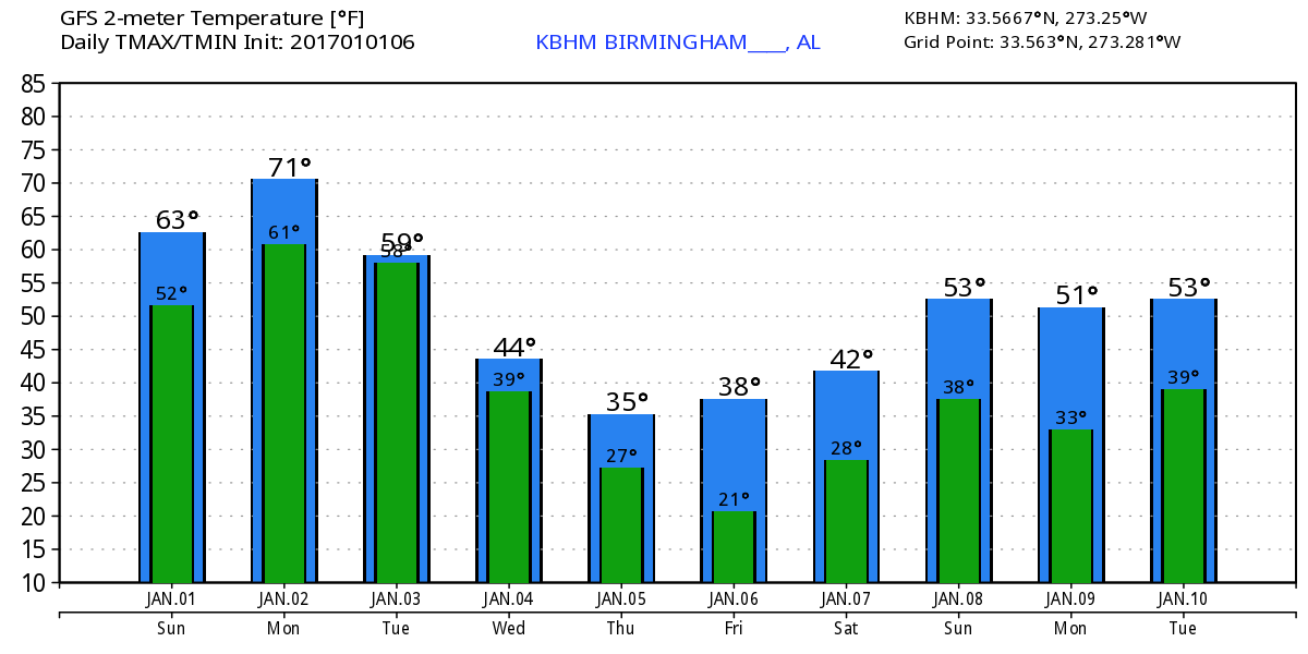
Clouds covered much of the Southeast US this morning along with a good deal of fog. Dense fog advisories were confined primarily to the Lower Mississippi River Valley across Arkansas and Louisiana. But for the first day of 2017, it was mild as temperatures overnight actually climbed under the influence of warm air advection and southerly flow. Readings across Alabama ranged from 66 at Mobile to 45 at Fort Payne. Most of the rain this morning was confined to Southeast Alabama but additional rain is expected to develop later this morning and this afternoon as the moisture out of the Pacific continues to pump into the Southeast US. Highs today should climb into the lower and middle 60s.
If you plan to head to New Orleans to see Auburn play against the Oklahoma Sooners in the Sugar Bowl with a 7:30 pm kickoff tomorrow night inside the Super Dome, thunderstorms will threaten the area through the day, so rain gear will be a good idea for going to and from the game. It will be warm in New Orleans with a low in the upper 60s and the afternoon high around 80.
Heading to the beach? It will be cloudy with multiple chances of rain today and into the start of upcoming week. Partly sunny days and fair nights are forecast later in the week. It will be mild for the next several days with highs in the lower 70s, but turning colder Wednesday with highs in the middle 60s. See the complete Gulf Coast 7 Day Planner here.
The closed low/trough over the Northwest Mexico this morning will eject northeastward on Monday bringing the threat of additional rain and the potential for severe weather to a large portion of Alabama. SPC has placed all of Alabama in a slight risk of severe storms with an enhanced risk covering nearly the southwestern third of the state including cities like Tuscaloosa, Livingston, Selma, Greenville, and Mobile. GFS develops a surface low over northern Louisiana around noon on Monday and moves it northeastward across Memphis by 6 pm and into the Ohio River Valley by 6 am Tuesday. CAPE values are projected to be in 1000 to 2000 j/kg range Monday afternoon gradually diminishing into the evening hours. Helicity values by 6 pm Monday are forecast to be in the 300 to 400 range, so besides the threat of damaging wind, it appears likely that there could be a tornado threat too. Mondays highs may reach the lower 70s with dew points in the lower 60s, so this three should definitely be taken seriously.
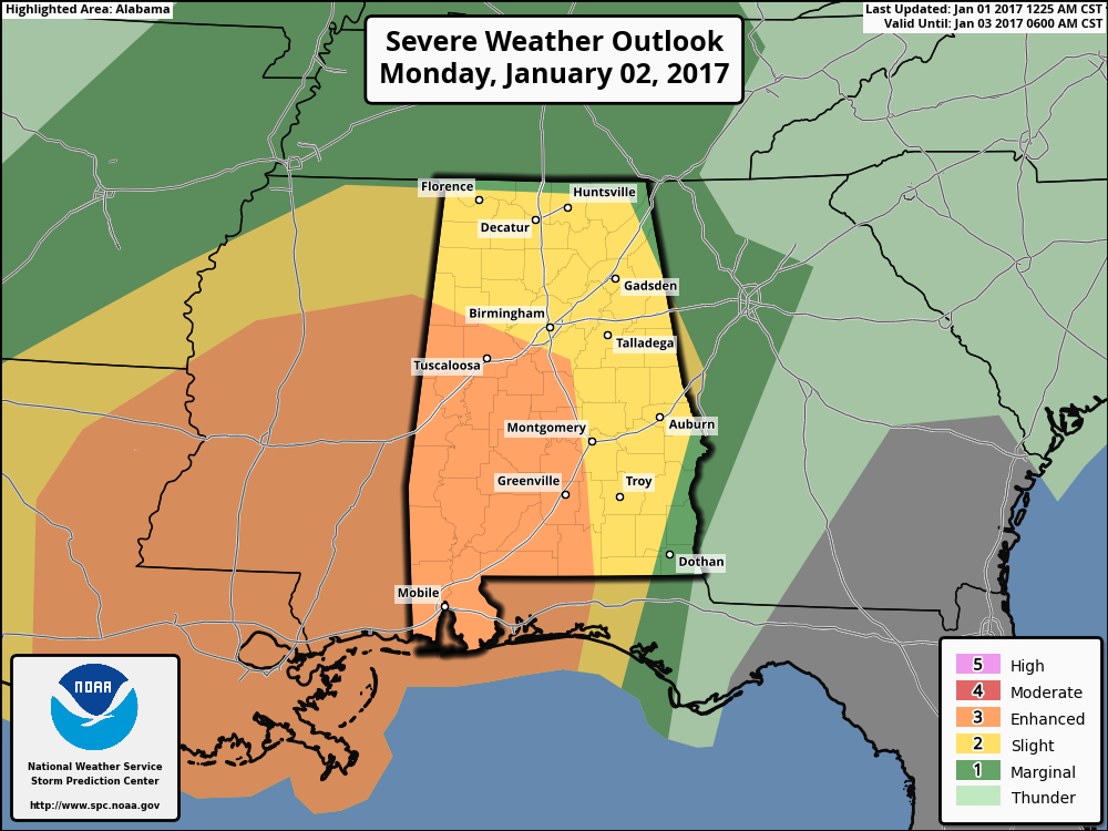
Since we’re coming off the holidays, today would be a good time to review your severe weather safety plans and be sure you have a good way – best to have more than one way – to get weather warnings. The greatest threat for severe storms appears to be between 11 am and 11 pm on Monday.
The upper short wave moves to the Mid-Atlantic States on Tuesday as the rain will end from the west across Alabama. It looks likely that we’ll remain cloudy through the day on Tuesday as the rain ends, but we might see a few breaks in the clouds by late afternoon. Based on the current frontal passage timing, temperatures Tuesday are probably going to be holding steady or falling during the day with daytime values in the lower 60s.
We gradually go under the influence of a broad developing trough on Wednesday and Thursday. This will put us under cold air advection for several days with temperatures gradually getting lower. Highs Wednesday will be in the upper 40s falling into the upper 30s on Thursday.

The models have done another flip flop for Friday. Yesterday the ECMWF was dry while the GFS showed some rain with a band of potential wintery precipitation. This run has flipped just the opposite with the GFS dry and the ECMWF showing a narrow band of light snow for Friday afternoon. There is little to no confidence in the forecast for the end of the week as long as the models keeping flipping. For now, my forecast is going to remain with the GFS for a rather cold but dry day on Friday. Any precipitation that does develop is likely to be light with the impact of any winter weather low. The GFS moves the surface high onto the Atlantic Coast on Saturday bringing a return of moisture back into the Lower Mississippi River Valley. This brings the possibility of rain into the forecast for next weekend, but the threat of any wintery precipitation with this pattern should be minimal as we warm up quickly under developing southerly flow.
Yesterday the GFS was pretty calm on the upper air patterns in voodoo country. This mornings 06Z GFS run is anything but calm! The upper air pattern now develops a fairly strong trough just to our west around the 10th and digs it into the East Coast by the 12th suggesting another round of pretty cold weather. But the upper flow goes into a strong ridge over the East with a closed low over Northwest Mexico by the 14th, a pattern very similar to the one we’re dealing with right now. So this would point to the potential for another multi-day rain event as the flow taps into Pacific moisture once again. Ain’t this fun?
Thanks for sticking with the Weather Xtreme Videos while James has had a bit of down time. He should be back with the next edition of the Weather Xtreme Video Monday morning. I’ll be subbing for Meaghan Thomas on ABC 3340 New at 5 and 10 pm today, so be sure to tune in for the latest on our wet and stormy situation. Have a great day and Godspeed.
-Brian-
Category: Alabama's Weather
About the Author (Author Profile)
Brian Peters is one of the television meteorologists at ABC3340 in Birmingham and a retired NWS Warning Coordination Meteorologist. He handles the weekend Weather Xtreme Videos and forecast discussion and is the Webmaster for the popular WeatherBrains podcast.Subscribe
If you enjoyed this article, subscribe to receive more just like it.


