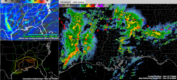
Strong Storms Over Tuscaloosa County Will Affect Western Jefferson County
Storms that prompted a severe thunderstorm warning over parts of Sumter and Greene Counties are over Tuscaloosa County now. They are currently affecting the City of Tuscaloosa.
They are moving north-northeast and will affect extreme western Jefferson County, staying close to the Walker/Jefferson County borders and will also impact much of Walker County. The main storms will stay west of the City of Birmingham.
The area of rain and storms associated with the disturbance appears to be increasing in coverage, so hopefully some of the rain will affect Birmingham. We need the rain.
They are producing tremendous amounts of lightning and some small hail but are not severe. Winds may gust to 40 mph.
At the Tuscaloosa Airport, the strongest wind gust was 18 mph. They have received 0.66 inches of rain however in just 34 minutes with 035 occurring between 8:18 and 8:27 a.m.
The storms are associated with a vigorous upper-level disturbance that is rotating out of Mississippi. You can see it as that brighter blue on the vorticity chart (top left segment of the graphic).
Look back to the west on the radar image and you see lots of storms over eastern Texas. Those are destined for us later today and this evening.
The bottom left panel of the graphic shows the SPC Severe Weather Outlook. Areas south of US-82 appear to have the greatest chance of severe weather today, but virtually the entire state with the exception of the northeast corner, is in the slight risk area.
Category: Alabama's Weather


