Winter Storm Potential Late This Week
WILD MONDAY: Unfortunately we had four fatalities in Alabama from the storms yesterday and last night; all of the deaths came at Rehobeth, in Houston County just south of Dothan. NWS survey teams will be in that area this morning to determine the size of the tornado. There was also considerable damage at Gulf Shores from a possible tornado, and some places had over 6 inches of rain. For a time Jackson, in Clarke County, was under a flash flood emergency.
Today will be much calmer, but clouds will linger for much of the day with a chance of a little drizzle or light rain in spots early this morning. It will be a mild January day with a high around 70 degrees.
COLDER AIR ROLLS IN TOMORROW: A gusty north wind will usher in much colder air; many North Alabama communities will hold in the 40s all day; the sky will remain generally cloudy with only a limited amount of sunshine. And, by Thursday morning we will drop below freezing with a low in the 28-32 degree range. The day Thursday will be cool and dry with a partly sunny sky and a high in the low 50s.
ARCTIC AIR ARRIVES FRIDAY: Some of the coldest air so far this season arrives Friday; the GFS is printing a high of only 36 degrees for Birmingham with an increasingly cloudy sky. And, as a wave of low pressure forms near the Gulf Coast, the stage is set for winter weather issues for the northern half of Alabama.
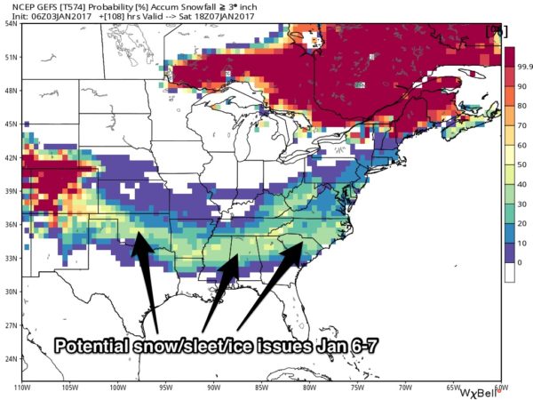
POTENTIAL WINTER STORM: We all know we have a limited skill set in dealing with wintry precipitation in Alabama, especially four days in advance. So there is no way to be extremely specific now, but with all global models on board, we can’t ignore the potential.

WHAT WE CAN TELL YOU NOW: There is a decent chance of accumulating snow or sleet somewhere over the northern half of Alabama Friday afternoon, Friday night, and into early Saturday morning. However, it is simply too early to forecast accumulation amounts, or exact placement.
Temperatures should fall well below freezing Friday night, meaning this has potential to be a “high impact” event with travel woes. This system will also have potential to impact other states across the southern U.S…
I usually draw up the first “accumulation potential” map once we get within 48 hours of an event, and that will be tomorrow night. For now, we can just tell you confidence is growing in the potential for a winter storm that could impact parts of North and Central Alabama. Stay tuned, and watch the Weather Xtreme video for all the maps, graphics, and more details.
Sunday will be cold and dry with a high in the 40-45 degree range.
NEXT WEEK: The first part of the week looks dry with a slow warming trend.
WEATHER BRAINS: Don’t forget you can listen to our weekly 90 minute netcast anytime on the web, or on iTunes. This is the show all about weather featuring many familiar voices, including our meteorologists here at ABC 33/40. We will produce this week’s show tonight at 8:30p CT… you can watch it live here.
CONNECT: You can find me on all of the major social networks…
Facebook
Twitter
Google Plus
Instagram
Look for the next Weather Xtreme video here by 4:00 this afternoon… enjoy the day!
Category: Alabama's Weather
About the Author (Author Profile)
James Spann is one of the most recognized and trusted television meteorologists in the industry. He holds the AMS CCM designation and television seals from the AMS and NWA. He is a past winner of the Broadcast Meteorologist of the Year from both professional organizations.Subscribe
If you enjoyed this article, subscribe to receive more just like it.


