

Tornado Warning Continues For Parts Of Bullock County Until 145 PM CST

At 111 PM CST, a confirmed tornado was located near Shopton, or 10
miles west of Union Springs, moving northeast at 45 mph.
HAZARD…Damaging tornado.
SOURCE…Radar confirmed tornado.
IMPACT…Flying debris will be dangerous to those caught without
shelter. Mobile homes will be damaged or destroyed. Damage
to roofs, windows, and vehicles will occur. Tree damage is
likely.
Locations impacted include…
Union Springs, Franklin Field, Shopton, Sedgefield and Simsville.
Tornado Warning Issued For Parts Of Bullock County
Jan 22nd @ 12:15 am

The National Weather Service in Birmingham has issued a
* Tornado Warning for…
Northern Bullock County in southeastern Alabama…
* Until 145 PM CST
* At 108 PM CST, a severe thunderstorm capable of producing a tornado
was located over Shopton, or 12 miles west of Union Springs, moving
northeast at 45 mph.
HAZARD…Tornado.
SOURCE…Radar indicated rotation.
IMPACT…Flying debris will be dangerous to those caught without
shelter. Mobile homes will be damaged or destroyed.
Damage to roofs, windows, and vehicles will occur. Tree
damage is likely.
* Locations impacted include…
Union Springs, Franklin Field, Shopton, Sedgefield and Simsville.
Severe Thunderstorm Warning Canceled for Tuscaloosa County
Jan 22nd @ 12:15 am
…THE SEVERE THUNDERSTORM WARNING FOR EAST CENTRAL TUSCALOOSA COUNTY
IS CANCELLED…
The storm which prompted the warning has moved out of the area.
Therefore the warning has been cancelled.
At 1236 AM CST, a severe thunderstorm was located over North Johns,
or near Hueytown, moving northeast at 60 mph.
HAZARD…60 mph wind gusts.
SOURCE…Radar indicated.
IMPACT…Expect damage to roofs, siding, and trees.
Locations impacted include…
Lake View, Brookwood, Abernant, Bull City and East Brookwood.
Severe Thunderstorm Warning Continues For Parts Of Tuscaloosa County Until 100 AM CST
Jan 22nd @ 12:15 am
At 1214 AM CST, a severe thunderstorm was located over Deerlick Creek
Campgrounds, or near Holt, moving northeast at 60 mph.
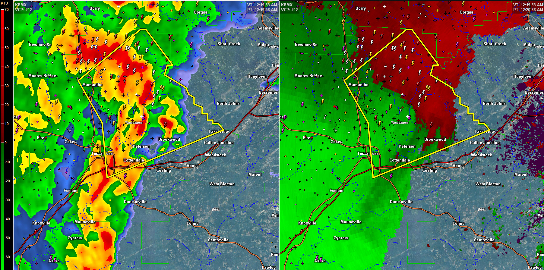
HAZARD…60 mph wind gusts.
SOURCE…Radar indicated.
IMPACT…Expect damage to roofs, siding, and trees.
Locations impacted include…
Tuscaloosa, Northport, Holt, Lake View, Brookwood, University Mall,
Deerlick Creek Campgrounds, Bankhead Lock And Dam, Abernant, Binion
Creek Landing, Bryant Denny Stadium, Samantha, McFarland Mall, Bull
City, Windham Springs, Whitson, East Brookwood, Peterson, Taylorville
and Wiley.
Severe Thunderstorm Warning Continues For Parts Of Tuscaloosa County Until 100 AM CST
Jan 22nd @ 12:05 am
At 1205 AM CST, a severe thunderstorm was located over Northport,
moving northeast at 60 mph.
HAZARD…60 mph wind gusts.
SOURCE…Radar indicated.
IMPACT…Expect damage to roofs, siding, and trees.
Locations impacted include…
Tuscaloosa, Northport, Holt, Lake View, Brookwood, Coker, Tuscaloosa
Amphitheater, University Mall, Deerlick Creek Campgrounds, Bankhead
Lock And Dam, Abernant, Tuscaloosa Regional Airport, Binion Creek
Landing, Bryant Denny Stadium, Samantha, McFarland Mall, Lake Lurleen
State Park, Bull City, Tierce Pattton Bridge and Windham Springs.
Severe Thunderstorm Warning Issued For Parts Of Tuscaloosa County
Jan 21st @ 11:58 pm
The National Weather Service in Birmingham has issued a
* Severe Thunderstorm Warning for…
Tuscaloosa County in west central Alabama…
* Until 100 AM CST
* At 1156 PM CST, a severe thunderstorm was located near Coker, or 9
miles southwest of Northport, moving east at 60 mph.
HAZARD…60 mph wind gusts.
SOURCE…Radar indicated.
IMPACT…Expect damage to roofs, siding, and trees.
* Locations impacted include…
Tuscaloosa, Northport, Holt, Lake View, Brookwood, Coker,
Tuscaloosa Amphitheater, University Mall, Deerlick Creek
Campgrounds, Bankhead Lock And Dam, Abernant, Tuscaloosa Regional
Airport, Binion Creek Landing, Bryant Denny Stadium, Samantha,
McFarland Mall, Lake Lurleen State Park, Bull City, Tierce Pattton
Bridge and Windham Springs.
Category: Current Warnings
About the Author (Author Profile)
Subscribe
If you enjoyed this article, subscribe to receive more just like it.


