A Nice Midday Out There Across Central Alabama
Good luck finding a cloud in the Alabama sky this afternoon as it is sunshine in full supply from one state line to the other. It is a cool day, but still temperatures are above average for this time of year. For the remainder of the day, skies will be sunny and afternoon highs will range from the lower to mid 60s across Central Alabama. Clouds will start to move in during the overnight hours tonight ahead of an approaching frontal boundary, but it will stay dry. Lows will range in the lower to mid 40s.
Temperatures Across Central Alabama
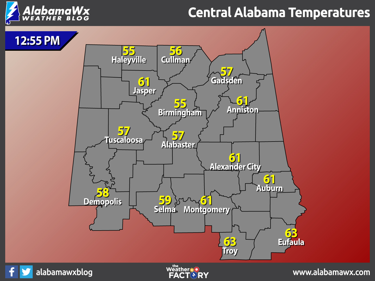
At 12:55 PM, temperatures are ranging from the mid 50s to the lower 60s across the area. The warm spots are currently Troy and Eufaula at 63 degrees. The cool spots are Haleyville and Birmingham at 55 degrees.
Birmingham’s Climatology And Records
The normal high for January 24th is 53, while the normal low is 32. The record high for today was set back in 1950 at 78 degrees. The record low was set back in 1963 at -2 degrees.
Warmer Tomorrow With A Few Showers Possible
A weak frontal boundary will push through Alabama late tomorrow. For the day tomorrow, clouds are going to be on the increase, and temperatures are going to climb into the upper 60s and lower 70s as our winds shift out of the south tonight. As the front pushes through, a few showers are expected. No threat of severe weather, and actually no thunder, so just a few passing showers, rain amounts should be 1/4 inch or less. The main window for rain will come late afternoon and through the evening hours.
For Those Who Are Beach Bound
Plenty of sunshine in the forecast, and though a few showers are possible early Thursday, the forecast looks pretty good at the beach. Highs will be in the 60s through much of the week. Click here to see the Beach Forecast Center page.
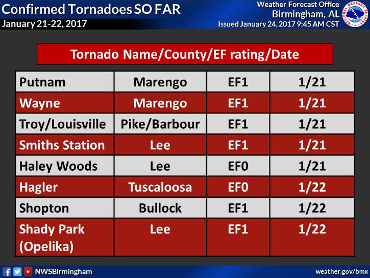
Storm Surveys So Far From Last Weekend
So far, the National Weather Service in Birmingham has confirmed 8 tornadoes touched down over the past weekend. Additional surveys are ongoing today. Thank you NWS Birmingham for the work you do.
On This Day In Weather History: 1982
Chinook winds plagued the foothills of southeastern Wyoming and northern and central Colorado for the second straight Sunday. The winds gusted to 140 mph at Wondervu CO, located northeast of Denver. Chinook winds a week earlier produced wind gusts to 137 MPH.
Come Hear Tim Marshall Tonight
Hey, are you a member of the Central Alabama Chapter of the National Weather Association? You love weather, right? Then you should be! Come hear a world class weather speaker tonight at Vulcan, when Tim Marshall will share his countless tornado stories. $10 will get you in, unless you’re a member, which is only $25 for the year. Join on the spot or online. Meet and greet at 6:00, meeting starts at 6:30. Be there!
Follow The Blog On Social Media
Remember that we are also on Facebook and on Twitter.
WeatherBrains
This week’s episode will be recorded tonight, featuring famed speaker and storm chaser, Tim Marshall. This is the weekly netcast that’s all about weather featuring many familiar voices, including our meteorologists at ABC 33/40. You can listen anytime on the web, or on iTunes. You can find it here.
Forecaster: Scott Martin (Twitter: @scottmartinwx)
Category: Alabama's Weather
About the Author (Author Profile)
Scott Martin is an operational meteorologist, professional graphic artist, musician, husband, and father. Not only is Scott a member of the National Weather Association, but he is also the Central Alabama Chapter of the NWA president. Scott is also the co-founder of Racecast Weather, which provides forecasts for many racing series across the USA. He also supplies forecasts for the BassMaster Elite Series events including the BassMaster Classic.Subscribe
If you enjoyed this article, subscribe to receive more just like it.


