Mostly Sunny Skies And Cool Out There Across Central Alabama At Midday
At the midday hour across Central Alabama, it’s a mix of sun and clouds out there, with rather cool temperatures and a little bit of a breeze at times. Winds are currently averaging around 12-18 MPH out of the west-northwest, and this will make it feel even cooler than what it is at this point. For the rest of the day, skies will be partly cloudy to mostly clear across Central Alabama. Winds will be averaging from 10-15 MPH throughout the rest of the afternoon, and will be slowing as the night approaches. Afternoon highs will be in the mid 40s to the lower 50s across the area. During the late night and overnight hours, skies will be mostly clear to partly cloudy. Lows will be in the upper 20s to the lower 30s.
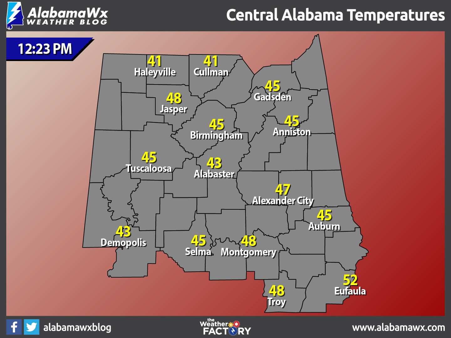
Temperatures Across Central Alabama
At 12:23 PM, temperatures are ranging from the lower 40s to the lower 50s across the area. The warm spot is currently Eufaula at 52 degrees. The cool spots are Haleyville and Cullman at 41 degrees.
Birmingham’s Climatology And Records
The normal high for January 27th is 54, while the normal low is 33. The record high for today was set back in 1944 at 76 degrees. The record low was set back in 1940 at 1 degrees.
Colder Air Arrives on Thursday
It will be a pretty nice, but cool day across Central Alabama for the first day of the weekend. Skies will be mostly clear to sunny, and afternoon highs will be in the lower to mid 50s across Central Alabama from north to south. Skies will be mostly clear for much of the area during the evening and overnight hours, with a few extra clouds for the extreme northern locations. Lows will dip down in the lower to mid 30s.
For Those Who Are Beach Bound
Plenty of sunshine in the forecast from today through Thursday of next week. Highs will be in the 50s for today through Monday, then warming into the 60s for Tuesday through Thursday. Click here to see the Beach Forecast Center page.
On This Day In Weather History: 1772
The “Washington and Jefferson Snowstorm” occurred. George Washington reported three feet of snow at Mount Vernon, and Thomas Jefferson recorded about three feet at Monticello.
Follow The Blog On Social Media
Remember that we are also on Facebook and on Twitter.
WeatherBrains
This week’s episode featured the famed speaker and storm chaser, Tim Marshall. What a great show it was. To see the latest of the weekly netcast that’s all about weather featuring many familiar voices, including our meteorologists at ABC 33/40. You can listen anytime on the web at Weatherbrains.com, or on iTunes.
Forecaster: Scott Martin (Twitter: @scottmartinwx)
Category: Alabama's Weather
About the Author (Author Profile)
Scott Martin is an operational meteorologist, professional graphic artist, musician, husband, and father. Not only is Scott a member of the National Weather Association, but he is also the Central Alabama Chapter of the NWA president. Scott is also the co-founder of Racecast Weather, which provides forecasts for many racing series across the USA. He also supplies forecasts for the BassMaster Elite Series events including the BassMaster Classic.Subscribe
If you enjoyed this article, subscribe to receive more just like it.


