A Beautiful & Cool Midday For Today, A Much Warmer Day on Tuesday
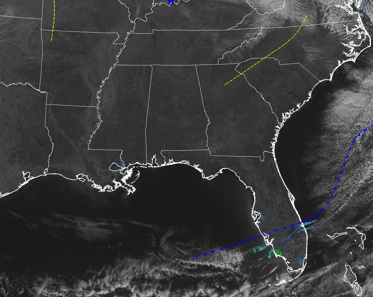
It’s a beautiful but cool day out there across Central Alabama at this midday hour. On the visible satellite, there is not a cloud over any part of the state. There may be a few small clouds out there, but they are too small to show up on the satellite. The nearest shower activity to the state is located in the southern part of the Florida Peninsula just ahead of a surface front.
The sun will be out in full force this afternoon, but temperatures will remain on the cool side even though highs will be a couple of degrees above normal. Afternoon highs will be in the mid 50s to the lower 60s across Central Alabama. A beautiful starlit sky will shine brightly over the area for tonight through the overnight hours. Lows will drop to the lower to mid 40s. A few colder spots will drop down into the 30s.
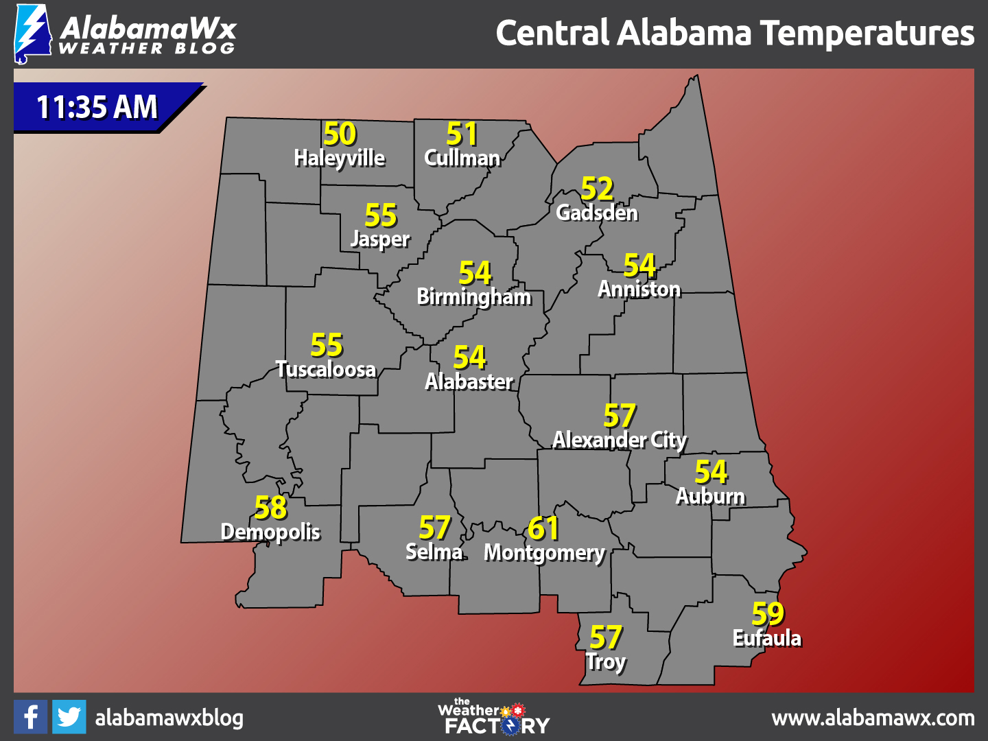
Temperatures Across Central Alabama
At 11:35 AM, temperatures are ranging from the lower 50s to the lower 60s across the area. The warm spot is currently Montgomery at 61 degrees. The cool spot is Haleyville at 50 degrees.
Birmingham’s Climatology And Records
The normal high for January 30th is 54, while the normal low is 33. The record high for today was set back in 1950 at 78 degrees. The record low was set back in 1966 at -4 degrees.
A Sunny And Warmer Day For Tuesday
With a surface ridge in place over the southeastern U.S., skies will be mainly sunny and temperatures will be around 10-15 degrees above normal. Afternoon highs on both days will be in the mid to upper 60s for much of the area, with a few locations making it to 70. Overnight lows will be in the 40s.
For Those Headed To The Beach
What a great week on the shores of the Gulf of Mexico from Fort Morgan over to Panama City Beach. Plenty of sunshine in the forecast from today through Friday. Highs will be in the 60s to lower 70s. Click here to see the Beach Forecast Center page.
National Extremes
The warmest high temperature set for the nation on Sunday afternoon was 83 degrees, set in Santa Ana, California. The coldest low temperature for Sunday night and into this morning was -18 degrees, set in Gunnison, Colorado. The highest rainfall total for the 24 hour period starting at 11AM Sunday night to 11AM today was 1.90 inches at Augusta, Georgia.
On This Day In Weather History: 1977
The great “Buffalo Blizzard” finally abated after three days. The storm added a foot of new snow to 33 inches already on the ground. Winds gusting to 75 mph reduced visibilities to near zero, produced snow drifts twenty-five feet high, and kept wind chill readings 50 degrees below zero. The blizzard paralyzed the city, and caused 250 million dollars damage.
Follow The Blog On Social Media
Remember that we are also on Facebook and on Twitter.
WeatherBrains
To hear the latest of the weekly netcast that’s all about weather featuring many familiar voices, including our meteorologists at ABC 33/40, you can listen anytime on the web at Weatherbrains.com, or on iTunes.
Forecaster: Scott Martin (Twitter: @scottmartinwx)
Category: Alabama's Weather
About the Author (Author Profile)
Scott Martin is an operational meteorologist, professional graphic artist, musician, husband, and father. Not only is Scott a member of the National Weather Association, but he is also the Central Alabama Chapter of the NWA president. Scott is also the co-founder of Racecast Weather, which provides forecasts for many racing series across the USA. He also supplies forecasts for the BassMaster Elite Series events including the BassMaster Classic.Subscribe
If you enjoyed this article, subscribe to receive more just like it.


