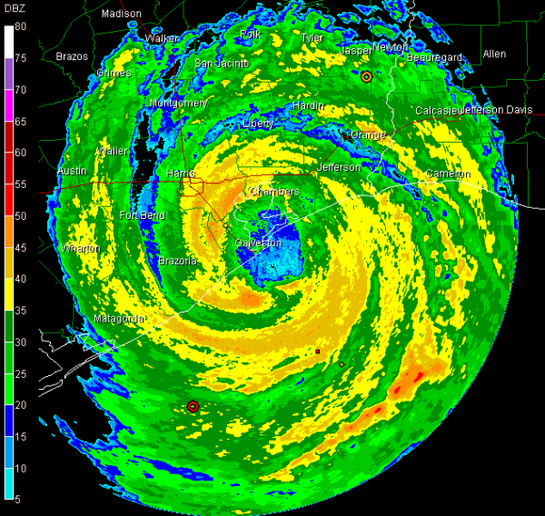
Houston Area Taking a Beating
The eye of Hurricane Ike moved inland over Galveston Island and the western end of the Bolivar Peninsula around 1:15 a.m. this morning.
The center should cross the coast in the next hour in the same area.
Reporters on Galveston say they are in the calm.
The strongest winds and weather are now moving into Dickinson…League City…and Kemah.
The rightside eyewall is moving inland near High Island…where extensive tidal surge devastation can be expected.
Galveston may escape the maximum surge…but I have heard reports that there is 4 feet of water in downtown Galveston.
Lots of power flashes over Houston now. Estimates are that 4.5 million Gulf Coast residents are without power.
A strom chaser in Galveston reports that his hotel is 100 yards from the seawall and there is at least one foot of water in the lobby. That is likely that Holiday Inn we saw ealrlier today on The Weather Channel.
Storm chaser Steve Miller reported 120 mph winds at Galveston befor ethe calm arrived.
The structure of Ike looks extremely organized at this hour. The storm really got its act together in the last 8 hours before landfall. But too late for the hurricane to grow much stronger.
Observations…from west to east…
Bay City…WNW 38 G 53
Pearland…wind instruments failed…last report N 33 G 54…pressure falling rapidly…down to 29.01
Angleton…pressure 977 mb…28.86
Hobby…N 54 G 74…peak wind 75 mph…28.94
Beaumont…ESE 59 G 91…29.17
Lake Charles..ESE 47 G 61
Category: Uncategorized


