A Brief Update On Central Alabama’s Weather On This Super Sunday
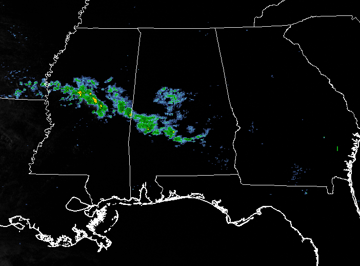
At the 6:00 PM hour, a line of showers are stretching from the extreme southern portions of Central Alabama back to the west-northwest into Central Mississippi and ending in the southeastern corner of Arkansas. All of the rain that is falling across the area is light in nature, but a few showers back in Mississippi are moderate to heavy. These are moving to the east, and will continue to move over the south-central parts of the area.
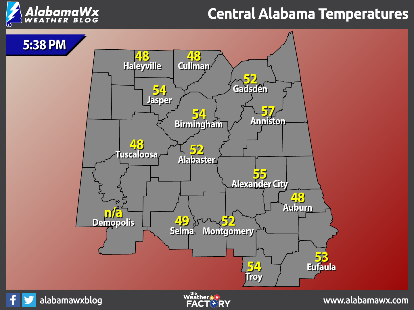
Temperatures Across Central Alabama
At 5:38 PM, temperatures are ranging from the lower 40s to the mid 50s across the area. The warm spot is currently Troy at 55 degrees. The cool spots are Haleyville, Cullman, Tuscaloosa, and Auburn at 48 degrees.
For The Rest Of The Evening
Continued cloudy skies across Central Alabama, with showers likely for locations mainly south of the I-20 corridor, but will begin to make a jog northward during the overnight areas. Rain totals for the remainder of the evening will be 1/4 inch or less. Overnight lows will be in the mid 40s to at or near 50 degrees.
More Clouds And Showers For Your Monday
Clouds will still be an issue across Central Alabama, and shower chances will continue through the morning. Those chances will begin to decrease from north to south as the afternoon progresses. One thing you will notice is that temperatures will be much warmer than today. Highs will make it up into the mid 60s to the lower 70s across the area. Rain totals should be around 1/4 inch or less.
Severe Weather Possibilities For This Week
We are continuing to monitor the threat of severe weather for Tuesday and Wednesday here in our area. There are mixed signals about whether this will be a significant event or not. Showers and storms that form Monday night will be edging toward Alabama Tuesday morning, reaching the northwest corner of the state by mid-morning. We should see mostly cloudy skies with a few breaks allowing the mercury to rise to near 70F or just above. That sunshine could be a big factor. Instability values will climb into the 500-1,000 joules/kg range, which is decent for thunderstorms. There will be a weak cap in place, with warm temperatures aloft perhaps stifling thunderstorm development during the morning. That is a good thing short term, but may lead to a stronger release of energy in the form of strong storms in the afternoon. There will be good speed shear in the atmosphere, which means storms that do form will be organized.
An upper trough will be taking on more of a negative tilt, or a northwesterly to southeasterly orientation, which can mean a greater transfer of energy. There will be drier air moving in aloft, which can enhance severe thunderstorm chances. But several ingredients may be less than optimal for severe weather. There will be warmer temperatures aloft putting a lid, or cap on the atmosphere. There will not be a strong upper level jet stream near the area. The surface low will be far to the north and surface winds will not be out of the more favorable southeasterly direction. The low level jet will be displaced to the northwest as well. So, we are not certain that the parameters will overlap to produce significant severe weather, yet. We will be watching.
Slight Risk For Severe Storms
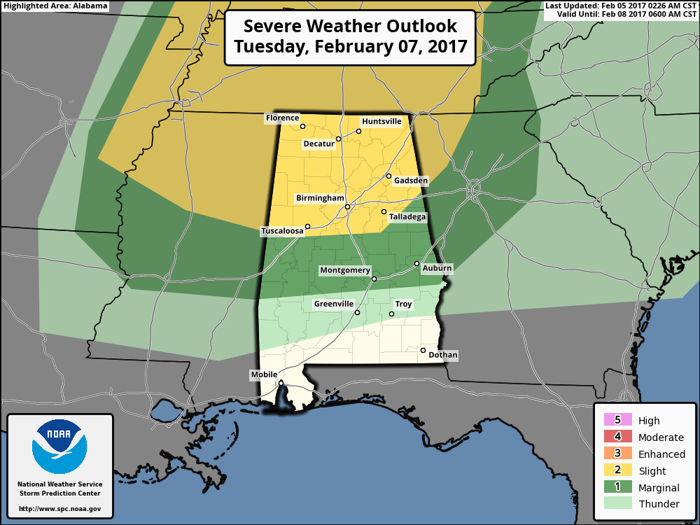
Tuesday, the SPC has their standard “slight risk” of severe weather for areas generally along and north of a line from Aliceville to Moundville to Calera to Heflin. A “slight risk” means that scattered severe storms are expected, or in other words, a good chance of severe weather. A “marginal Risk”, meaning isolated severe storms expected, extends down to south of Montgomery and Auburn. The fact that the SPC has the risk delineated on their Day 3 Outlook does portend a higher level of confidence that severe weather is likely. No question, the threat is greater to the north, but it is one we will have to take very seriously.
How Does It Evolve
It is just too early to tell. Those showers and storm will be approaching northwest Alabama Tuesday morning and will skirt across the Tennessee Valley. Will more showers and storms develop further south with the cap in place and the warmer temperatures aloft? Will the upper support lift out to the north, leaving us high and dry. These are the questions that will come into clearer focus over the next 24 hours.
More Action Wednesday Night
The airmass won’t really change Tuesday and we will be waiting for the main cold front to arrive Wednesday. Showers and storms could form late Wednesday afternoon and evening across the state. Storms could be strong to severe, especially is areas from Chilton and Coosa counties southeast into Montgomery, Auburn and Eufaula.
Action Steps
Just keep the severe weather threat in mind and check the latest forecast information. We will have an update this evening and frequent updates on Monday and through the event.
Category: Alabama's Weather
About the Author (Author Profile)
Scott Martin is an operational meteorologist, professional graphic artist, musician, husband, and father. Not only is Scott a member of the National Weather Association, but he is also the Central Alabama Chapter of the NWA president. Scott is also the co-founder of Racecast Weather, which provides forecasts for many racing series across the USA. He also supplies forecasts for the BassMaster Elite Series events including the BassMaster Classic.Subscribe
If you enjoyed this article, subscribe to receive more just like it.


