Cloudy Skies With A Few Showers Out There At Midday Across Central Alabama
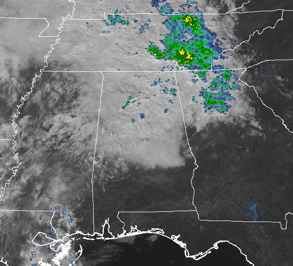
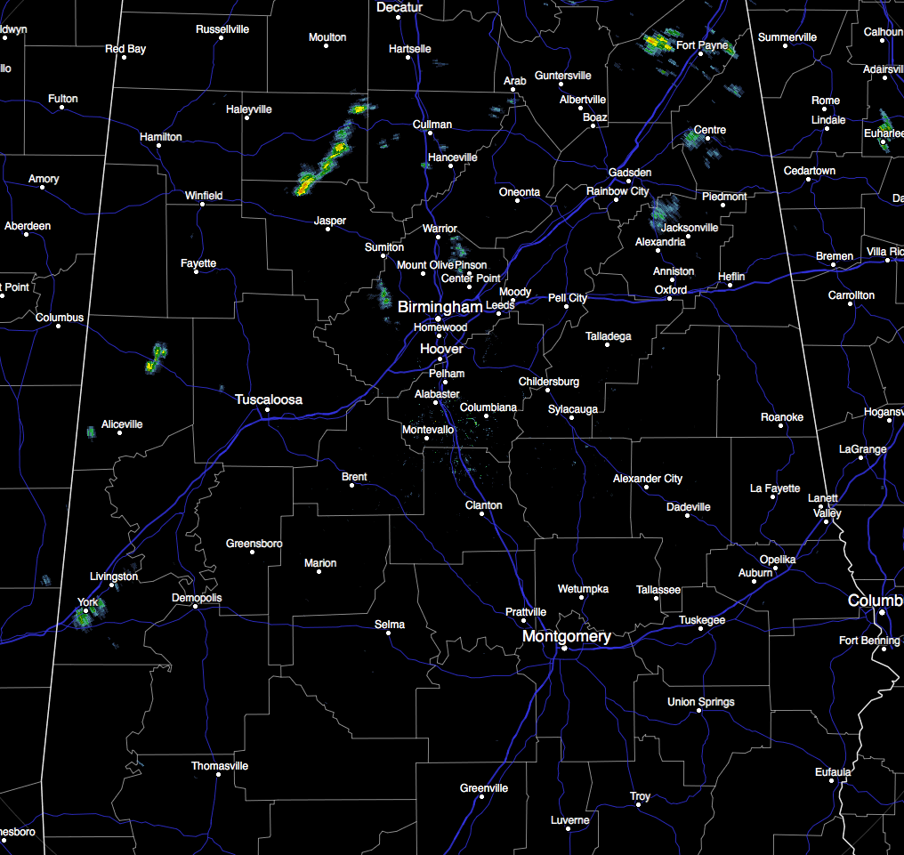
At the 1 o’clock hour across Central Alabama, skies are generally cloudy with the exception for the very extreme southeastern locations where the sun is still currently shining. As far as any shower activity, there are some spotty showers mainly north of the I-20 corridor, with the heaviest over parts of Winston and Walker counties. These are all pushing off to the east-northeast.
Showers will be decreasing in coverage in the northern half for the remainder of the afternoon, with some sun shining in the southeastern parts of Central Alabama. Afternoon highs will top out in the lower 60s to the mid 70s from north to south. Skies will remain cloudy for the evening and overnight hours, but rain chances will have diminished before sunset. Overnight lows will be in the mid to upper 70s.
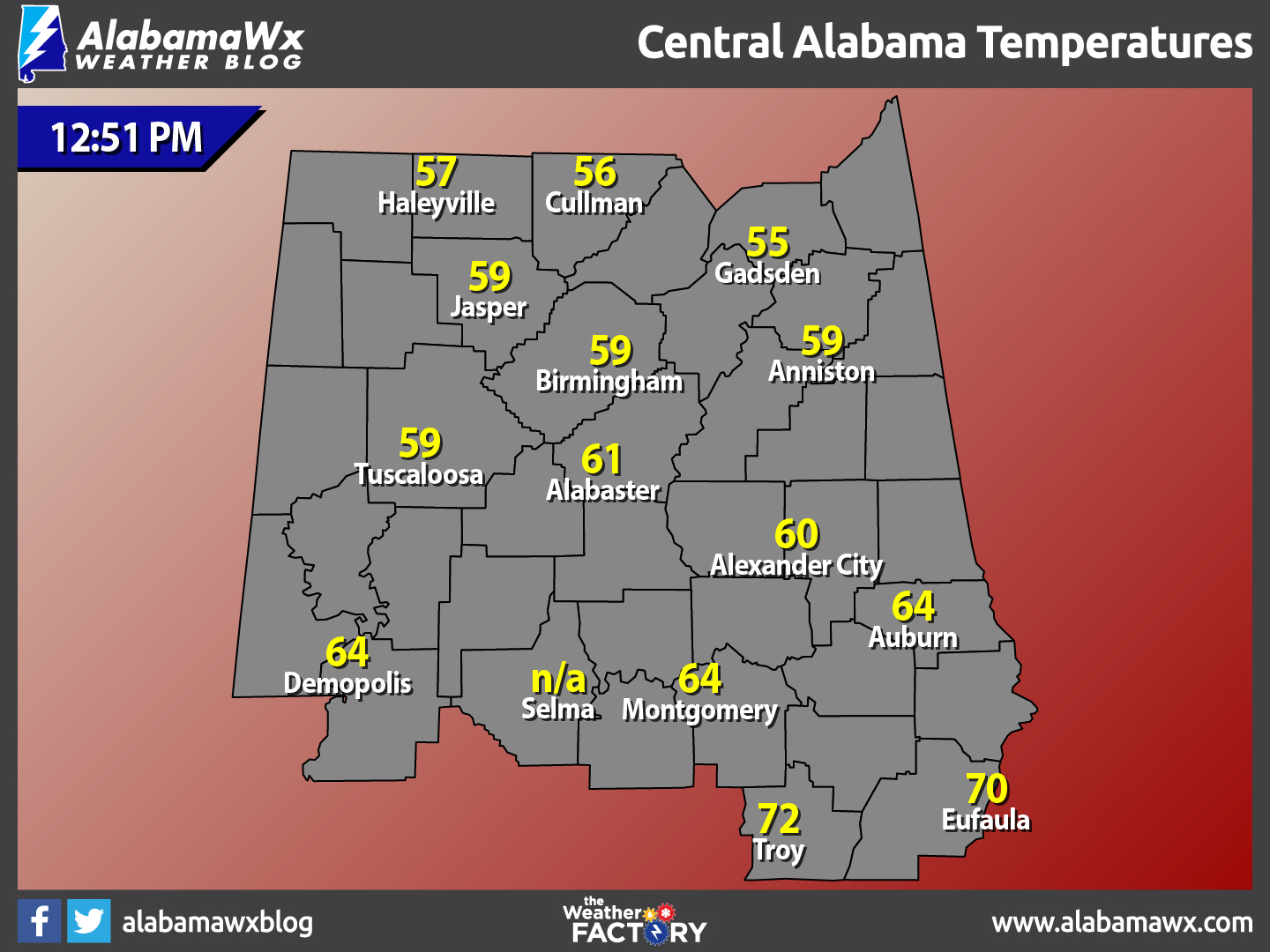
Temperatures Across Central Alabama
At 12:51 PM, temperatures are ranging from the mid 50s to the lower 70s across the area. The warm spot is currently Troy at 72 degrees. The cool spots is Gadsden at 55 degrees.
Birmingham’s Climatology And Records
The normal high for February 6th is 56, while the normal low is 34. The record high for today was set back in 1999 at 76 degrees. The record low was set back in 1988 at 15 degrees.
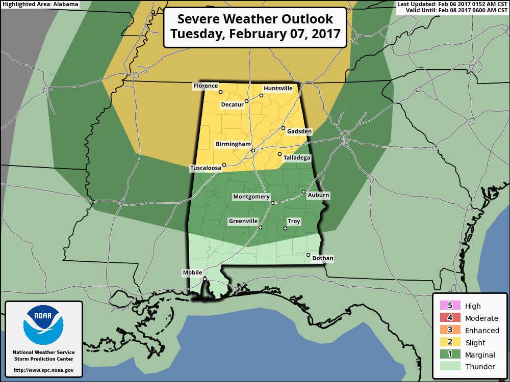
Severe Storms Possible On Tuesday
The Storm Prediction Center continues to have pretty much all of the northern half of the state in a Slight Risk for severe storms, with a Marginal Risk down into South Alabama for tomorrow. We will have unstable air move into the area thanks to the combination of a cold front approaching along with an upper trough. Our afternoon highs will be in the upper 60s to the mid 70s across the areas.
Thunderstorms will move into the northwestern parts of the state late tomorrow morning, and we’ll have a good chance of showers and storms during the afternoon and evening. While there will be a fair amount of shear across North Alabama, model guidance suggests instability values will be relatively low, with higher wind fields aloft and CAPE values remaining west of the state. The main window for strong to severe storms will come from 11:00 AM until 7:00 PM, with the primary issues being strong straight line thunderstorm winds and hail. The tornado threat is low, but not zero. Rain amounts of around 1/2 inch are likely, with isolated amounts to 1 inch where the heavier storms develop. Flooding is not expected.
For Those Headed To The Beach
Mostly sunny skies for the remainder of the day today, with thunderstorms possible for Tuesday and wednesday. Mostly clear skies to end out the week and weekend. Highs will be in the 60s and 70s. Click here to see the Beach Forecast Center page.
National Extremes
The warmest high temperature set for the nation on Sunday afternoon was 85 degrees, set in Edinburg, Texas. The coldest low temperature for Sunday night and into this morning was -4 degrees, set in St. Mary, Montana. The highest precipitation total for the 24 hour period starting at 12PM Sunday to 12PM today was 1.52 inches at Portland, Oregon.
On This Day In Weather History: 1988
Arctic cold invaded the south central and eastern U.S. Sixteen cities reported new record low temperatures for the date. Squalls in the Great Lakes Region produced a foot of snow at Arcade NY in three hours.
Follow The Blog On Social Media
Remember that we are also on Facebook and on Twitter.
WeatherBrains
To hear the latest of the weekly netcast that’s all about weather featuring many familiar voices, including our meteorologists at ABC 33/40, you can listen anytime on the web at Weatherbrains.com, or on iTunes.
Forecaster: Scott Martin (Twitter: @scottmartinwx)
Category: Alabama's Weather
About the Author (Author Profile)
Scott Martin is an operational meteorologist, professional graphic artist, musician, husband, and father. Not only is Scott a member of the National Weather Association, but he is also the Central Alabama Chapter of the NWA president. Scott is also the co-founder of Racecast Weather, which provides forecasts for many racing series across the USA. He also supplies forecasts for the BassMaster Elite Series events including the BassMaster Classic.Subscribe
If you enjoyed this article, subscribe to receive more just like it.


