A Stormy Midday Across Central Alabama
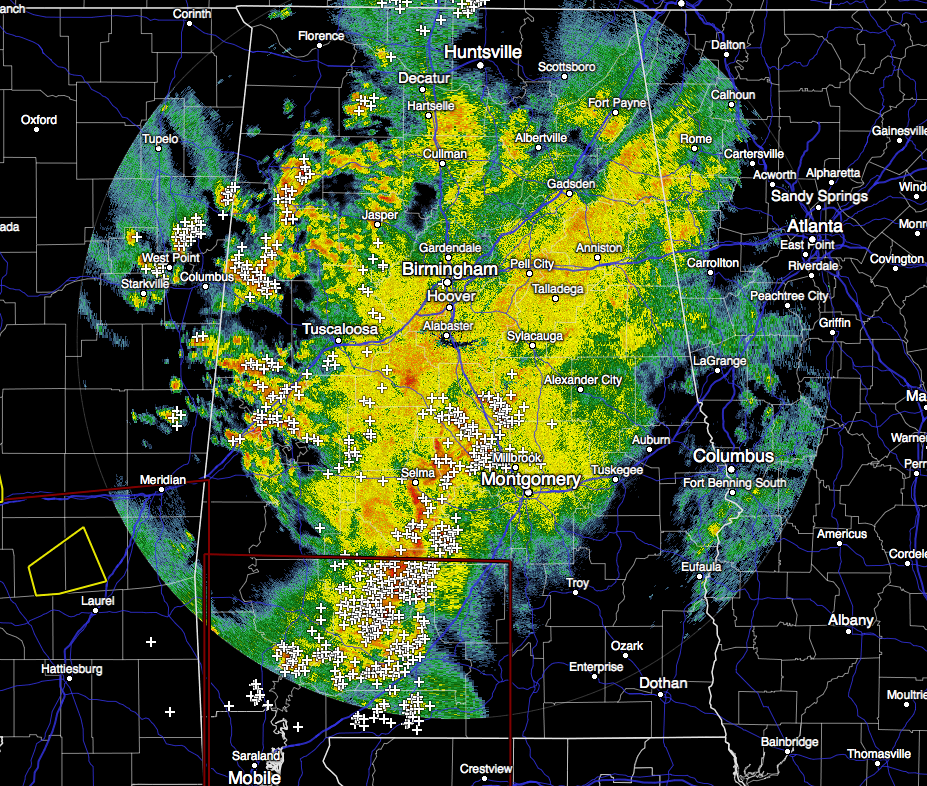
Currently across the area, showers and thunderstorms continue to move to the east, as the individual cells within the rain shield are moving to the northeast. There are no active watches or warnings in effect for Central Alabama.
At this time, severe thunderstorms are occurring in the eastern parts of Louisiana and in the southern parts of Mississippi, and multiple tornado warnings are in effect. There is one impressive couplet signature just east of New Orleans. There has been photos on social media of a large tornado on the ground as it went through the eastern parts of New Orleans. At this point, I do not have any reports of damage, but I’m sure there will be some major damage where this storm hit.
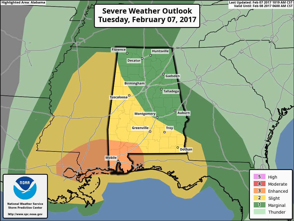
The severe weather threat has diminished for areas north of a line from Uniontown to Dadeville to Lafayette. Southeast of that line, in the highlighted area, there is still a limited threat of severe weather this afternoon. With that being said, the Storm Prediction Center has removed locations in the northeastern half of the state from the slight risk for severe storms, but still remains in a marginal risk mainly for gusty winds and small hail.
We will be watching that swarm of supercells over Louisiana that has produced a significant tornado near Madisonville and New Orleans over the past hour. These storms will affect southern Alabama and may morph into a big damaging wind threat for that part of the state.
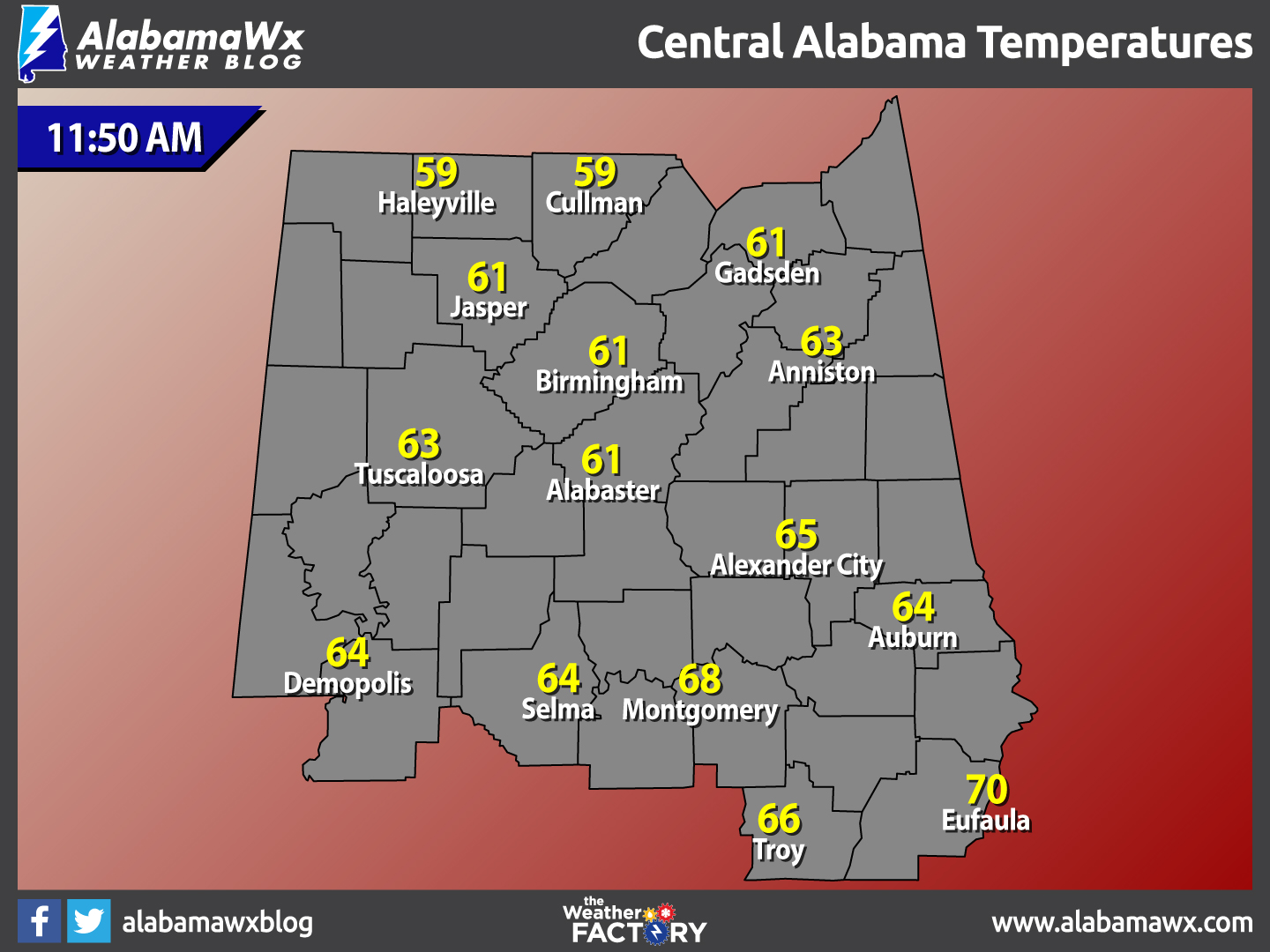
Temperatures Across Central Alabama
At 11:50 AM, temperatures are ranging from the upper 50s to near 70 degrees across the area. The warm spot is currently Eufaula at 70 degrees. The cool spots are Haleyville and Cullman at 59 degrees.
Birmingham’s Climatology And Records
The normal high for February 7th is 56, while the normal low is 35. The record high for today was set back in 1999 at 76 degrees. The record low was set back in 1988 at 12 degrees.
For The Rest Of The Evening
Some showers and a few thunderstorms could develop back to the west of the storms moving through at this moment, but the likelihood of any of those (if they develop) becoming severe is unlikely. Otherwise, rainfall will be coming to an end by the late afternoon to the early evening tonight. Lows for the overnight hours will be in the 50s.
Could Wednesday Involve More Strong Storms?
A surface front will pass through, but the severe weather threat is very conditional. A capping inversion could very well keep most of the day storm-free, but if a storm can punch through, then it could be strong with potential for some hail and strong gusty winds. SPC has a decent part of the state in a “marginal” risk for severe weather tomorrow. Highs will be in the 70s for most in Central Alabama.
For Those Headed To The Beach
Storms likely for the remainder of the day today, with thunderstorms possible for Wednesday. Mostly clear skies to end out the week and weekend. Highs will be in the 60s and 70s. Click here to see the Beach Forecast Center page.
National Extremes
The warmest high temperature set for the nation on Monday afternoon was 88 degrees, set in Alice, Texas. The coldest low temperature for Monday night and into this morning was -19 degrees, set in Houlton, Maine. The highest precipitation total for the 24 hour period starting at 12PM Monday to 12PM today was 1.06 inches at Cleveland, Ohio.
On This Day In Weather History: 1990
A slow moving cold front spread heavy snow across the state of Utah. Storm totals ranged up to 31 inches at Alta, with 24 inches at reported Brighton and 23 inches at Snowbird. Bitter cold weather prevailed across Alaska for the thirteenth day in a row, with morning lows of -42 degrees at Fairbanks, -48 degrees at Nenana, and -54 degrees at Bettles. Anchorage AK reported a record low of 23 degrees below zero.
Follow The Blog On Social Media
Remember that we are also on Facebook and on Twitter.
WeatherBrains
To hear the latest of the weekly netcast that’s all about weather featuring many familiar voices, including our meteorologists at ABC 33/40, you can listen anytime on the web at Weatherbrains.com, or on iTunes.
Forecaster: Scott Martin (Twitter: @scottmartinwx)
Category: Alabama's Weather
About the Author (Author Profile)
Scott Martin is an operational meteorologist, professional graphic artist, musician, husband, and father. Not only is Scott a member of the National Weather Association, but he is also the Central Alabama Chapter of the NWA president. Scott is also the co-founder of Racecast Weather, which provides forecasts for many racing series across the USA. He also supplies forecasts for the BassMaster Elite Series events including the BassMaster Classic.Subscribe
If you enjoyed this article, subscribe to receive more just like it.


