Below Normal Temperatures And A Little Breezy At Midday Across Central Alabama
Clear skies and cool temperatures are the story across Central Alabama at the midday hour. The cold front that brought us the thunderstorms on Wednesday night has now pushed well to our east and southeast in to the Florida Peninsula and the open waters. Rain totals were meager from last night, but a few places received some decent rain amounts. Calera received 0.49 inches, and Tuscaloosa got 0.28 inches. Most of everyone else received totals well less than 1/4 inch or none at all.
For the remainder of the afternoon, skies will remain sunny and temperatures will be pretty cool. Afternoon highs will be in the upper 40s to the mid 50s across the area from north to south. It will be quite breezy out there as well, with winds averaging 5-15 MPH out of the northwest, with some gusts approaching 20 MPH. Definitely need a light jacket or windbreaker.
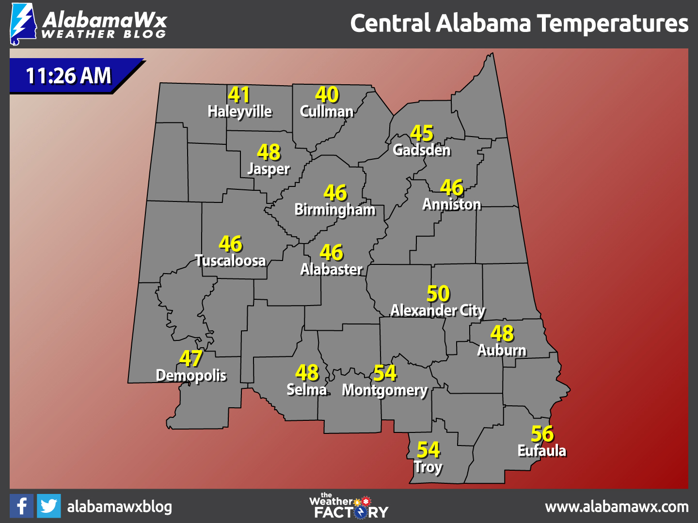
Temperatures Across Central Alabama
At 11:26 AM, temperatures are currently running in the lower to mid 40s in the northern parts of the area, with upper 40s to mid 50s in the south. The warm spot is currently Eufaula at 56ºF, while the cool spot is Cullman at 40ºF.
Clear & Cold For Your Thursday Night
You will definitely need to grab your coat if you are heading out tonight. Skies will be clear and temperatures will be chilly. Overnight lows will fall into the mid 20s to the lower 30s across Central Alabama.
Birmingham’s Average Temperatures February 9th
- Average High – 57ºF
- Average Low – 36ºF
Birmingham’s Record Temperatures February 9th
- Record High – 77ºF set back in 1957.
- Record Low – 7ºF set back in 1933.
Sunny & Much Warmer For Your Friday
The warming trend begins on Friday… After early morning temperatures start off in the mid 20s to the lower 30s across the area, they will make a nice recovery and be mild for the afternoon. Daytime highs will be in the lower to mid 60s across Central Alabama, which will be 4-8 degrees above normal for this time of the year. A few clouds will move in for your Friday night, but skies will remain mostly clear. Overnight lows will be quite warmer, only falling into the 40s across the area.
Weather History For February 9th
- 1990 – Thunderstorms developing ahead of a cold front erupted over eastern Texas late in the morning, and produced severe weather as they swept across the southeastern states. Early evening thunderstorms spawned a tornado which injured one person at Nat TX, and produced tennis balls size hail which caused more than half a million dollars damage around Shreveport LA.
- 1987 – A storm off the Atlantic coast produced high winds and heavy snow in the northeastern U.S., with blizzard conditions in eastern Massachusetts. Wind gusted to 80 mph and 23.4 inches of snow produced drifts eight feet high at Cape Cod MA. It was the worst blizzard in thirty years for the Cape Cod area. Winds in some of the mountains and ridges of the Appalachian Region gusted to 100 mph.
- 1933 – The temperature at Moran, WY, located next to Teton National Park, plunged to 63 degrees below zero to establish a state record. The temperature at the Riverside Ranger Station in Montana dipped to 66 below zero to establish a record for the state, and a record for the nation which stood until 1954.
Coming Monday: A New Look & More Content for AlabamaWX
You’ve come to count on the AlabamaWX Weather Blog for the very latest and most detailed weather information for Central Alabama. We love delivering this content to you. On Monday, the site’s look will change to a magazine format. People have told us that they like the ease of use of the blog, but hate having to scroll endlessly to see other important content. They don’t like missing important stories that might be buried by more recent posts. The new blog will be the best of both worlds, displaying nearly 25 stories in a space that is about one tenth the length of the current chronological first page. No more missing an interesting story from a day ago.
James has prepared a 6 minute orientation video to the new look blog. Please take time to watch it and get familiar with the look.
Whenever you make a change, there will always be people who like the old way better. But as James says on his video, give it a chance and I think you will like what we have done to the blog. When you wake up Monday morning, the new look will be there! We’re excited!
Follow The AlabamaWx Weather Blog On Social Media
We are on social media! Be sure to follow us on Facebook and on Twitter.
WeatherBrains
To hear the latest of the weekly netcast that’s all about weather featuring many familiar voices, including our meteorologists at AlabamaWx, you can listen anytime on the web at Weatherbrains.com, or on iTunes. You can also watch our latest video on the live site at BigBrainsMedia.com.
Category: Alabama's Weather
About the Author (Author Profile)
Scott Martin is an operational meteorologist, professional graphic artist, musician, husband, and father. Not only is Scott a member of the National Weather Association, but he is also the Central Alabama Chapter of the NWA president. Scott is also the co-founder of Racecast Weather, which provides forecasts for many racing series across the USA. He also supplies forecasts for the BassMaster Elite Series events including the BassMaster Classic.Subscribe
If you enjoyed this article, subscribe to receive more just like it.


