Line of Showers Is Feeding on Unstable Air, Overcoming Cap
UPDATE 423 PM
The shower over Smith Lake has grown into a thunderstorm, as have the ones just east of Cullman. They now both are producing lightning. They are on track to affect Cullman and Blount Counties, and clip southwestern Etowah County.
They eventually will skirt northern Jefferosn County and move into St. Clair and Calhoun Counties.
ORIGINAL POST 404 PM
Our cold front is into the northwest corner of Alabama at this time.
A line of showers has formed ahead of it, as expected.
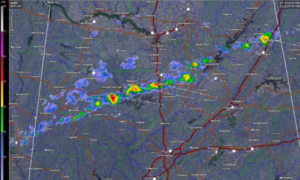
We had thought that a strong inversion aloft would keep the showers from gaining enough height to get enough charge separation o produce lightning.
But one of them has grown to heights of 45,000 feet or so over the DeKalb/Jackson County line between Henagar and Valley Head. A good bit of lightning in this storm.
Now back along the line, other showers and trying to become storms as well. One near Cullman, between Lynn and Arley, and another south of Addison are the best candidates for now.
The activity is pushing east southeast at 35 mph. The heavier cells will affect mainly Winston, northeastern Walker, Cullman, Blount and Etowah Counties over the next hour. The southeastern Winston County cell may clip northeastern Jefferson County. as well.
Category: Alabama's Weather
About the Author (Author Profile)
Bill Murray is the President of The Weather Factory. He is the site's official weather historian and a weekend forecaster. He also anchors the site's severe weather coverage. Bill Murray is the proud holder of National Weather Association Digital Seal #0001 @wxhistorianSubscribe
If you enjoyed this article, subscribe to receive more just like it.


