

Widespread Rain For Alabama Tomorrow
FINE FEBRUARY AFTERNOON: Temperatures are in the 70s across Alabama this afternoon with sunshine through high clouds. Those clouds will thicken and lower tonight, however, and we will deal with wet weather tomorrow.
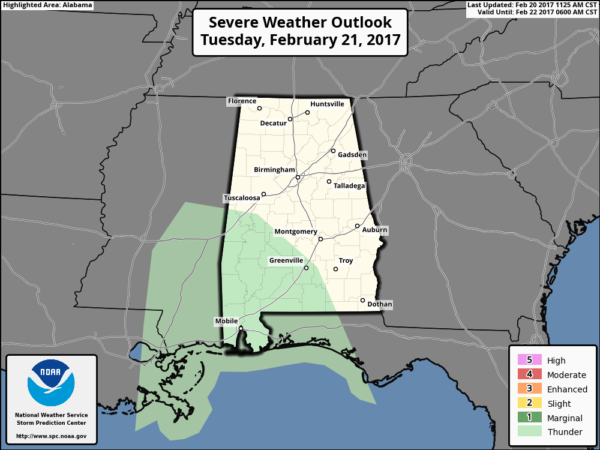
RAIN RETURNS: Rain will become widespread across Alabama by mid to late morning tomorrow, and the rain continues tomorrow afternoon into tomorrow night. There is no risk of severe weather, and we probably won’t hear much thunder.
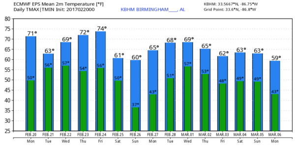
Rain amounts of 1/2 to 1 inch are likely before the rain ends early Wednesday morning. And, tomorrow will be cooler because of the clouds and rain; we will hover between 60 and 65 degrees much of the day.
WEDNESDAY: Lingering rain should end pretty early in the day, but I am not sure we see much sunshine. We will continue to forecast “gradual clearing” during the afternoon, but it might be Wednesday night before the clouds exit the state. The high Wednesday afternoon should be close to 70 degrees.
THURSDAY/FRIDAY: Thursday will be very mild and dry with a partly sunny sky; we rise into the mid 70s. Then, on Friday, a deep surface low will pass well north of the state, with a potential severe weather event for Indiana and some of the adjacent states. But, here in Alabama, the atmosphere should be capped off during the day Friday with limited moisture, so the daytime hours look generally dry with temperatures again pushing well up into the 70s.
We will mention a chance of showers and storms Friday night with the passing cold front, but for now the threat of severe weather looks rather low with the main dynamic support so far north.
THE ALABAMA WEEKEND: Noticeably cooler air arrives Saturday. Despite a mostly sunny sky, we will have a hard time getting out of the 50s with a cool north breeze. Then, early Sunday, temperatures fall into the 30s, and colder spots will have a pretty good chance of seeing a late season freeze. Then, during the day Sunday, expect sunshine in full supply with a high close to 60 degrees.
NEXT WEEK: A rather unsettled pattern develops across the Deep South, with potential for a round of strong to severe storms as a deep surface low passes northwest of Alabama. Very difficult to determine timing, however, due to model inconsistency and differences. The latest GFS run (12Z) hints the main window for strong storms will come at mid-week on Wednesday, but that could easily change. See the Weather Xtreme video for maps, graphics, and more details.
Click here to see the Beach Forecast Center page. Save Up To 25% on Spring Break Beach Vacations on the Alabama Gulf Coast with Brett/Robinson! The Beach Forecast is partially underwritten by the support of Brett/Robinson Vacation Rentals in Gulf Shores and Orange Beach. Click here to see Brett/Robinson’s best beach offers now!.
WEATHER BRAINS: Don’t forget you can listen to our weekly 90 minute netcast anytime on the web, or on iTunes. This is the show all about weather featuring many familiar voices, including our meteorologists here at ABC 33/40. We will produce this week’s show tonight at 8:30 CT… you can watch it live here.
CONNECT: You can find me on all of the major social networks…
Facebook
Twitter
Google Plus
Instagram
Pinterest
Snapchat: spannwx
Look for the next Weather Xtreme video here by 7:00 a.m. tomorrow…
Category: Alabama's Weather
About the Author (Author Profile)
James Spann is one of the most recognized and trusted television meteorologists in the industry. He holds the AMS CCM designation and television seals from the AMS and NWA. He is a past winner of the Broadcast Meteorologist of the Year from both professional organizations.Subscribe
If you enjoyed this article, subscribe to receive more just like it.


