Wednesday Evening Weather Xtreme Discussion – Severe Threat Nearly Gone, Cooler Weather Ahead
Evening Weather Xtrme Update
By Ryan Stinnett and Bill Murray
Our man Spann was busy this afternoon doing television, so no video. He will be back bright and early with a new video tomorrow morning. But here is an updated discussion as of 615 p.m.
The month of March roared in like a lion across Alabama today, but fortunately damage was light. The severe weather situation is calming quite nicely early this evening as the atmosphere slowly loses instability and wind energy.
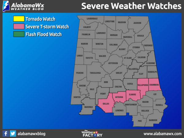
SEVERE THUNDERSTORM WATCH: A severe thunderstorm watch remains in effect for a band of counties across Central Alabama until 9 p.m., but as soon as the line of storms passes your location, your severe weather threat is over.
SETUP: Thankfully for this event, the main low pressure center was well up into the Great Lakes. However, a strong cold front moving into a very warm, and unstable air mass triggered the storms. Strong southerly flow and a mix of sun and clouds allowed temperatures to surge into the upper 70s and lower 80s across the state, with even some mid 80s down south. Montgomery set a record for the date with 85F, smashing the old record of 82F.
Dew points were in the 60s, and combined with the temperature profile of the atmosphere, allowed our CAPE (instability) values to climb into the 750-1,400 J/kg range. Additionally, there was over 60 knots of speed shear, meaning organized storms with strong updrafts. There was 250 m2/s2 of low level helicity over the northern third of Alabama giving the storms some spin.
RADAR CHECK: Just after 6 p.m., the line of storms extends from Lafayette to White Hall to Thomasville to Milry. It will move through Montgomery and Prattville between 630 and 730 p.m. The storms will be moving out of the state around 10 or 11PM.
FOR TONIGHT: Much colder air will rush into the state overnight, and we should see a clearing sky, with temperatures by first thing tomorrow morning down into the upper 30s and lower 40s.
GEOMAGNETIC STORM: A G1-class polar geomagnetic storm is in progress on March 1st as Earth enters a fast-moving stream of solar wind. This is sparking bright auroras around the Arctic Circle. The solar wind is flowing from a large canyon-shaped hole in the sun’s atmosphere and is expected to influence Earth for the next two days.
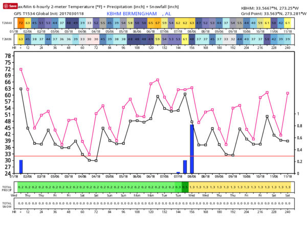
TRENDING COOLER: Thursday and Friday will be highlighted by the new, and more seasonal air mass that arrives behind the front. Both days will be dry, with ample sunshine, cool days, and chilly nights. The highs tomorrow will be in the low 60s, followed by upper 50s Friday. Lows will be back down into the 30s and many places will see a light freeze early Friday morning. Expect cooler conditions for the next 10 days, but not abnormally so.
THE FIRST WEEKEND OF MARCH: The weather stays dry and a very nice weekend is shaping up across the state. We are going to see a slow warming trend and after lows in the 28-33 degree range early Saturday, we project a high in the low 60s Saturday, followed by upper 60s Sunday. The sky will stay mostly sunny both days.
NEXT WEEK: Monday will be mild and dry, but clouds move in Tuesday, and a band of showers and storms will move through late Tuesday and Tuesday night ahead of a cold front. For now the severe weather threat looks low and then cooler, drier air returns for the latter half of the week.
BEACHBOUND: Storms later tonight, but beautiful weather returns tomorrow with gorgeous weather through the weekend. Click here to see the Beach Forecast Center page. Save Up To 25% on Spring Break Beach Vacations on the Alabama Gulf Coast with Brett/Robinson! The Beach Forecast is partially underwritten by the support of Brett/Robinson Vacation Rentals in Gulf Shores and Orange Beach. Click here to see Brett/Robinson’s best beach offers now!.
WORLD TEMPERATURE EXTREMES: Over the last 24 hours, the highest observation was 113.0F at Ngqura, South Africa. The lowest observation was -73.8F at Dome A, Antarctica.
CONTIGUOUS TEMPERATURE EXTREMES: The highest observation was 96F at McAllen, TX. The lowest observation was -8F at Big Piney, WY.
WEATHER ON THIS DATE IN 1910: The deadliest avalanche of record in the U.S. thundered down the mountains near Wellington Station, WA sweeping three huge locomotive train engines and some passenger cars, snowbound on the grade leading to Stevens Pass, over the side and into a canyon, and burying them under tons of snow. The avalanche claimed the lives of more than 100 people. The station house at Wellington was also swept away.
Category: Alabama's Weather, ALL POSTS
About the Author (Author Profile)
Bill Murray is the President of The Weather Factory. He is the site's official weather historian and a weekend forecaster. He also anchors the site's severe weather coverage. Bill Murray is the proud holder of National Weather Association Digital Seal #0001 @wxhistorianSubscribe
If you enjoyed this article, subscribe to receive more just like it.


