A Quick Look At The Central Alabama Weather Situation At 5PM
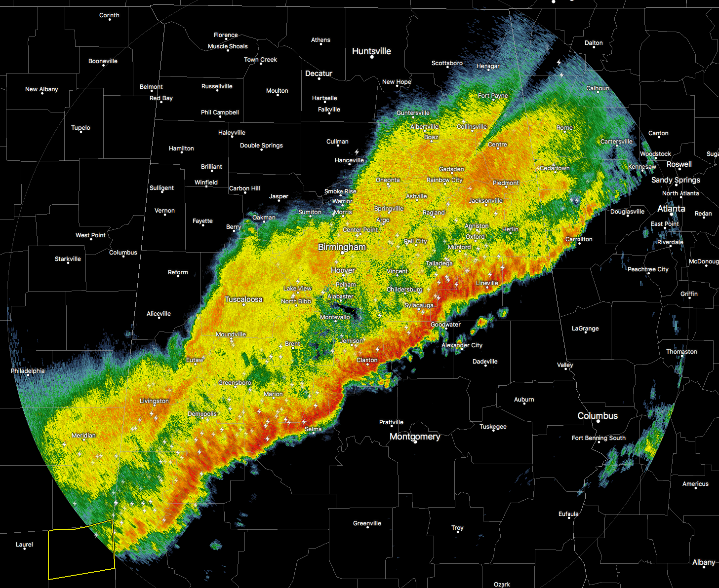
The line of showers and thunderstorms are continuing to push across Central Alabama, with the leading edge now stretching from Ranburne in Cleburne County, back to the southwest through Sylacauga to Maplesville to Thomaston in Marengo county.
At this point, it looks like the parts of the line with the strongest winds would be just east of Sylacauga and Gantts Quarry in Talladega County, and just south of Maplesville and a few miles east of Billingsley. There is still plenty of lightning along the line, so just stay indoors if you can until the system passes.
The line in Central Alabama is currently under severe limits, but back to our southwest in southeastern Mississippi, a severe thunderstorm warning is in effect for Wayne County until 5:15PM, with the threat being from 60 MPH wind gusts and quarter-size hail. As of now, that is the only active warning in the entire southeast.
This line of storms should continue to weaken as we continue to lose the daytime heating, and the line moves into a more stable atmosphere with lower dewpoints and lesser values of instability.
The front of the line has now actually moved out of the area defined under a “slight risk” for severe storms and into the “marginal risk” areas. The best chance for any storm to become severe will be of the southwest 1/4 of the state (south of I-20/59 and west of I-65).
The rain has come to an end in Cullman, Jasper, Fayette, Gordo, and Aliceville. The back of the rain should reach the cities of Tuscaloosa, Birmingham, and Gadsden within the next hour or two. Temperatures are still in the upper 60s to the lower 70s out ahead of the line, but have already started dropping into the upper 50s to lower 60s behind that. Lows should drop into the lower 30s to the upper 40s for much of the area just north of I-85, with lower to mid 50s to the south of that.
Tomorrow’s weather will be really nice, with mostly clear skies and mild temperatures. Afternoon highs will be back in the upper 60s to the mid 70s across the area from north to south. Be sure to take your lunch break outdoors if you can, you won’t go wrong.
Category: Alabama's Weather, ALL POSTS
About the Author (Author Profile)
Scott Martin is an operational meteorologist, professional graphic artist, musician, husband, and father. Not only is Scott a member of the National Weather Association, but he is also the Central Alabama Chapter of the NWA president. Scott is also the co-founder of Racecast Weather, which provides forecasts for many racing series across the USA. He also supplies forecasts for the BassMaster Elite Series events including the BassMaster Classic.Subscribe
If you enjoyed this article, subscribe to receive more just like it.


