Severe Thunderstorm Warning Continues For Parts Of Marion County (Expired)
UPDATE 1216 AM
Severe thunderstorm is between Hamilton and Natural Bridge at 12:16 a.m. Moving east along US-278. Hail and high winds possible.

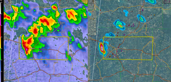
…A SEVERE THUNDERSTORM WARNING REMAINS IN EFFECT UNTIL 1230 AM CST FOR NORTHEASTERN MARION COUNTY… At 1212 AM CST, a severe thunderstorm was located over Lake Buttahatchee, or 9 miles southwest of Haleyville, moving east at 45 mph.
HAZARD…60 mph wind gusts and half dollar size hail.
SOURCE…Radar indicated.
IMPACT…Hail damage to vehicles is expected. Expect wind damage to roofs, siding, and trees. Locations impacted include… Haleyville, Lake Buttahatchee, Brinn, Bear Creek and Piney Grove.
Severe Thunderstorm Warning Continues For Parts Of Marion County Until 12:30AM
Mar 9th @ 11:49 pm

…A SEVERE THUNDERSTORM WARNING REMAINS IN EFFECT UNTIL 1230 AM CST FOR NORTHEASTERN MARION COUNTY… At 1158 PM CST, a severe thunderstorm was located near Hamilton, moving east at 45 mph.
HAZARD…Ping pong ball size hail and 60 mph wind gusts.
SOURCE…Radar indicated.
IMPACT…People and animals outdoors will be injured. Expect hail damage to roofs, siding, windows, and vehicles. Expect wind damage to roofs, siding, and trees. Locations impacted include… Hamilton, Haleyville, Weston, Lake Buttahatchee, Brinn, Bear Creek, Rankin Fite Airport, Pearces Mill and Piney Grove.
Severe Thunderstorm Warning Issued For Parts Of Marion County Until 12:30AM
Mar 9th @ 11:49 pm

Strong thunderstorms are making lots of noise over Northwest Alabama tonight.
The strongest cells are from west of Russellville and Phil Campbell to west of Hamilton. Large hail is indicated in the storm west of Hamilton. Winds could reach 60s mph as well.
Another strong storm is northeast of Phil Campbell. They extend up to southwest of Town Creek and to west of Athens.
Leave mobile homes for substantial structures and stay in a safe area.
Additional storms are upstream over northeastern Mississippi and a line of strnog storms will sweep through the area after midnight.
A severe thunderstorm watch is in effect for North and North Central Alabama until 4 a.m. CST.
Here are the details from the warning:
The National Weather Service in Birmingham has issued a
* Severe Thunderstorm Warning for…
Central Marion County in northwestern Alabama…
* Until 1230 AM CST
* At 1148 PM CST, a severe thunderstorm was located over Weston, or near Hamilton, moving east at 45 mph.
HAZARD…60 mph wind gusts and half dollar size hail.
SOURCE…Radar indicated.
IMPACT…Hail damage to vehicles is expected. Expect wind damage to roofs, siding, and trees.
* Locations impacted include…
Hamilton, Haleyville, Weston, Lake Buttahatchee, Brinn, Bear Creek, Rankin Fite Airport, Pearces Mill and Piney Grove.
Category: ALL POSTS, Archived Warnings
About the Author (Author Profile)
Subscribe
If you enjoyed this article, subscribe to receive more just like it.


