

Showers Continuing to Move Across North/Central Alabama At The Midday Hour
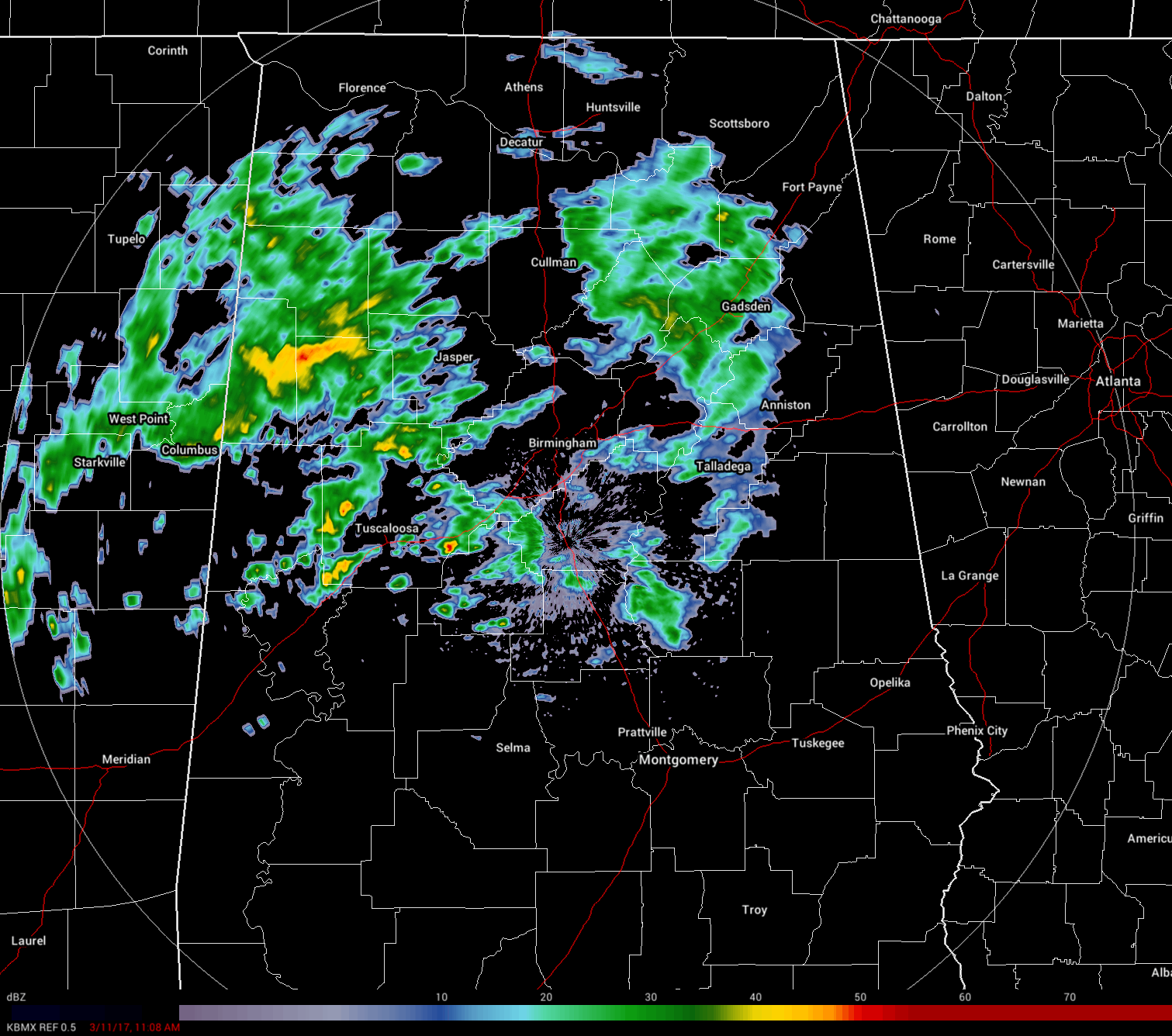
At the midday hour, showers are moving across north and central Alabama mainly affecting areas north of a line from Demopolis to Clanton to Alexander City. Most of the shower activity is light to moderate, but a few in the western parts of Central Alabama are putting down some heavy rainfall at the moment. These showers are moving to the east at around 40-45 MPH.

For the rest of North/Central Alabama, skies are generally cloudy where the rain is not currently falling. For the southern parts of the state, a good amount of sunshine is making it to the surface. Today would be a great day at the beach if the temperatures were just a little bit warmer.
REST OF THE DAY
Skies will continue to be cloudy and showers will continue to push across the area throughout the remainder of the day, and temperatures will remain cool. Afternoon highs will be in the 50s for the northern half of Central Alabama, with 60s to the low 70s in the south. Temperatures will be dropping into the mid 30s to the upper 40s across Central Alabama, with rain likely throughout the evening. Rain amounts for tonight will be in the 1/4 to 1/2 inch range. There should be no wintry issues for Central Alabama, but some freezing rain or light snow could fall over the extreme northern parts of the Tennessee Valley at the back side of the system, but no issues are expected.
CLEARING AND QUITE WINDY FOR SUNDAY
Rain will be moving out of the area during the morning hours and skies will begin to clear. There will be no wintry issues for Central Alabama, but some freezing rain or light snow could fall over the extreme northern parts of the Tennessee Valley at the back side of the system, but no issues are expected. Daytime highs will reach the upper 50s to the lower 60s across the area. Skies will start to cloud over again but the evening should remain dry of Sunday night, with overnight lows dropping into the upper 30s to the lower 40s.
THE WORK WEEK AHEAD
We will have several short wave impulses move through Central Alabama throughout the week as a trough will be over the eastern United States. The first impulse will move through on Monday afternoon through Tuesday morning. This will bring our next chance of rain during that time, and we’ll have wrap-around moisture during the daytime and into the evening hours on Tuesday. Another impulse will move through on Friday afternoon through Saturday morning, bringing with it another chance of rain with a flurry or two possible as it exits. Highs will be in the mid 50s to mid 60s on Monday and Tuesday across the area, dropping back into the upper 40s to the mid 50s for Wednesday, then back up into the mid to upper 50s for Thursday, and back into the mid to upper 60s on Friday.
WHAT TO EXPECT AT THE BEACH
For a detailed look at the weather from Fort Morgan over to Panama City Beach, click here to see a on our Beach Forecast Center page. Save Up To 25% on Spring Break Beach Vacations on the Alabama Gulf Coast with Brett/Robinson! The Beach Forecast is partially underwritten by the support of Brett/Robinson Vacation Rentals in Gulf Shores and Orange Beach. Click here to see Brett/Robinson’s best beach offers now!
WEATHERBRAINS
WeatherBrains kicked off a month of blockbuster guests as the Director of the Storm Prediction Center, Dr. Russ Schneider, climbed in the hot seat earlier this week. Also this week as a Guest Panelist was Jen Watson, from the Storm Freaks podcast. Jen is a Social Media Specialist and Meteorologist at the Weather Channel. She is a part of the Storm Freaks Front podcast. Some issues talked about included consistency and collaboration between the messages of the SPC and local forecast offices, recent changes at the center and new and improved products on the horizon. The threat of governmental cutbacks and other factors affecting the National Weather Service were discussed as well. You can catch this week’s show these outlets: WeatherBrains website or subscribe to the podcast on iTunes.
THE BLOG IS ON SOCIAL MEDIA
@AlabamaWxBlog on Facebook
@AlabamaWxBlog on Twitter
WANT TO ADVERTISE ON THE ALABAMAWX WEATHER BLOG
Deliver your message to a highly engaged audience by advertising on the newly reformatted AlabamaWX.com website. The site enjoyed 10.2 MILLION page views in the past 12 months. Don’t miss out! We can customize a creative, flexible and affordable package that will suit your organization’s needs. Contact Bill Murray at (205) 687-0782.
Category: Alabama's Weather, ALL POSTS
About the Author (Author Profile)
Scott Martin is an operational meteorologist, professional graphic artist, musician, husband, and father. Not only is Scott a member of the National Weather Association, but he is also the Central Alabama Chapter of the NWA president. Scott is also the co-founder of Racecast Weather, which provides forecasts for many racing series across the USA. He also supplies forecasts for the BassMaster Elite Series events including the BassMaster Classic.Subscribe
If you enjoyed this article, subscribe to receive more just like it.


