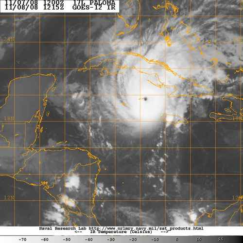
Paloma Pounds Caymans
People on Grand Cayman went to bed last night listening to their storm shutters banging in a stiff ENE breeze, but knowing that the worst was over for them as the center passed about 30 miles to their east. They had lots of heavy rain and gale force winds through the afternoon and evening, but it was nothing like Ivan in 2004, which damaged nearly every building on the islands.
They are awakening this morning to find that their sister islands about 85 miles to the east northeast were not so lucky. Paloma continued to intensify rapidly overnight and grew into a category four hurricane with top winds of 140 mph. Just before 4 a.m. CST, Air Force reconnaissance found a pressure of 945 millibars and a 154 mph flight level wind less than ten miles south of Little Cayman. It was a rough time for the folks there.
A pressure of 939 millibars and a 154 mph flight level wind were observed by the plane just before 6 o’clock central time time morning as the center was less than ten miles south of Cayman Brac.
REPORT FROM THE ISLANDS
Mike Barcroft is on the South Side of Cayman Brac. He has been posting reports all night to the StormCarib blog. Here is his latest from just before 6 a.m.
Pressure 962.1 and falling at indicated rate of 16.8 per hour – wind out of N-NE and highest gust 108.4 MPH. Somewhat rugged out there! Wind howling and horizontal sheets of water in the air, blowing down the street like sideways waterfalls. MB
RADIO CAYMAN
Listen to the radio from the Caymans on the internet.
A report just was broadcast on Radio Cayman that a roof blew off a shelter in Cayman Brac. Other calls report that roofs have been blown off homes on the Brac. People are taking shelter in central parts of their homes.
GEOGRAPHY CLASS
The Cayman Islands are among the most beautiful places on earth. Rising from the Cayman Trench in the Caribbean, the islands are actually the tops of mountains from the Cuban Maestra Range that extend above the water south of Cuba. Seventy percent of the economy comes from tourism. Another large part comes from tax haven banking.
Grand Cayman is the largest island and where most of the development is located. Two sister islands lie to the east northeast of Grand Cayman. Little Cayman is about 84 miles from Grand Cayman, and is the smallest at just ten square miles. Less than 170 people live there. Five miles to the east is Cayman Brac. Brac means bluff, named for the large bliff on the eastern end of the island. It is fourteen square miles and sparsely populated.
The Caymans location makes them one of the world’s premiere SCUBA diving spots. It also makes them vulnerable to hurricanes. In fact, they are one of the most hurricane prone spots on earth. I read a statistic that they are effected by a hurricane every 2.23 years on average.
Category: Uncategorized


