Very cold air
As James and I have been talking about all week, the cold air coming in over the next week or so looks pretty intense…with multiple models in agreement. We have already had numerous periods of cold air, since September, and we continue to be a little ahead of schedule.
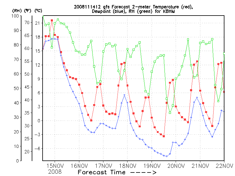
Take a look at the raw GFS output for surface temps in BHM over the next week (from coolwx.com).
(Click on it for a clearer graphic)
These times are in GMT, so subtract 6 hours for CST (ie., 00 UTC 15 Nov is actually this evening at 6 pm). Notice how temperatures fall all day tomorrow (wind chills will be in the 30s), stay in the 40s Sunday, and then with a re-inforcing shot of cold air, stay in the 30s for a good part of the day Tuesday, with wind chills near 30 at times during the day. We finally make it back into the mid to upper 50s late next week, but our normal highs for mid-November are in the lower 60s. Also note that this model shows our temperatures going below freezing 5 nights out of the next 7, with lows way down in the 20s Tuesday night. If winds go calm, some spots could reach 19 degrees by Wednesday morning.
Category: Uncategorized
About the Author (Author Profile)
Subscribe
If you enjoyed this article, subscribe to receive more just like it.


