

More Rain Monday, Significant Mid-Week Freeze, An Early Morning Snow Stripe from Space
Skies have cleared for areas west of a line from Heflin to Shorter to Luverne to Evergreen. Low clouds were trying to work their way back in to East Alabama from Georgia. That’s the old dreaded easterly wedge ramping up as the high over the Mid-Atlantic oozes around the Appalachian Mountains.
COOL SUNDAY: Highs are topping out in the 50s in the sunny areas. Auburn and Trop are still in the 40s at 45F and 48 respectively. We will be in the middle 30s north tonight, upper 30s middle and lower 40s across the southern part of Central Alabama.
MONDAY RAIN: A strengthening upper level disturbance now in the Rockies will push into Arkansas by tomorrow afternoon. Clouds will increase ahead of this feature and there could be a shower or two by lunchtime. But the main area of rain will move into Alabama by early afternoon and will make a slow trip across the state during the afternoon and evening hours. Rainfall amounts should average just over a quarter inch. Not much, but we will take it as we try to erase our continuing 90 day rainfall deficit. It is now 14.5 inches at Birmingham for the past 365 days.
WATCHING FOR A SIGNIFICANT FREEZE: Expect breezy and clearing conditions on Tuesday with highs struggling to get out of the 40s thanks to a strong northerly breeze that will be bringing in colder air. There could be a few light showers on Tuesday. Could there be a snowflake or two mixed in over North Alabama. Nah…. But lows Tuesday night will fall into the middle and upper 20s. It will be even colder Wednesday night with lows ranging between 21-27F across Central Alabama. That will be the most significant freeze since mid-February and with all the recent warmth prompting early growth, look for the NWS to issue a freeze watch at some point probably tomorrow. Highs Wednesday really may stay in the 40s all day unless a strong late winter sun can carry the day. Look for 50s Thursday.
NEXT SYSTEM: Look for our next weathermaker to arrive Friday afternoon out of the northwest again with another area of rain. There have been some signs that some precip could arrive early Friday morning, and that could be problematic for North Alabama If it occurs. Low there could be close to freezing still Friday morning. But the chance appears low at this time and Central Alabama seems to be in the clear for any problems. Friday highs will be in the middle and upper 50s. Rainfall amounts with this next system look like the one Monday night, around one quarter inch.
SEVERE THREAT THE LAST WEEK OF THE MONTH: The GFS paints a picture that looks like a severe threat may be on the boards for the 24th and 25th. But that’s Voodooland, so let’s get a little closer before we worry about it.
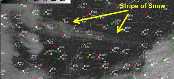
SNOW STRIPE
Visible satellite pictures early this morning clearly revealed a narrowing stripe of snow from eastern Arkansas near Harrison through Jackson TN to just west of Chattanooga. 1-3 inches of snow fell in that narrow band overnight. 3” in Kingston Springs and Vanleer were some of the best amounts I found. in southern Middle Tennessee. 3-4 inches fell in Union City and 4-6 inches in Paris in western Tennessee. Amounts over northern Mississippi were lighter, less than 1 inch. Social media reports showed a nice ½ – ¾ layer of snow in places like Muscle Shoals, Florence and Harvest. Huntsville saw a dusting.
Category: Alabama's Weather, ALL POSTS
About the Author (Author Profile)
Bill Murray is the President of The Weather Factory. He is the site's official weather historian and a weekend forecaster. He also anchors the site's severe weather coverage. Bill Murray is the proud holder of National Weather Association Digital Seal #0001 @wxhistorianSubscribe
If you enjoyed this article, subscribe to receive more just like it.


