

Cloudy, Chilly, and Some Showers Across Central Alabama at Midday, With More Rain Coming
CLOUDY AND COOL AT MIDDAY, WITH RAIN LIKELY TODAY
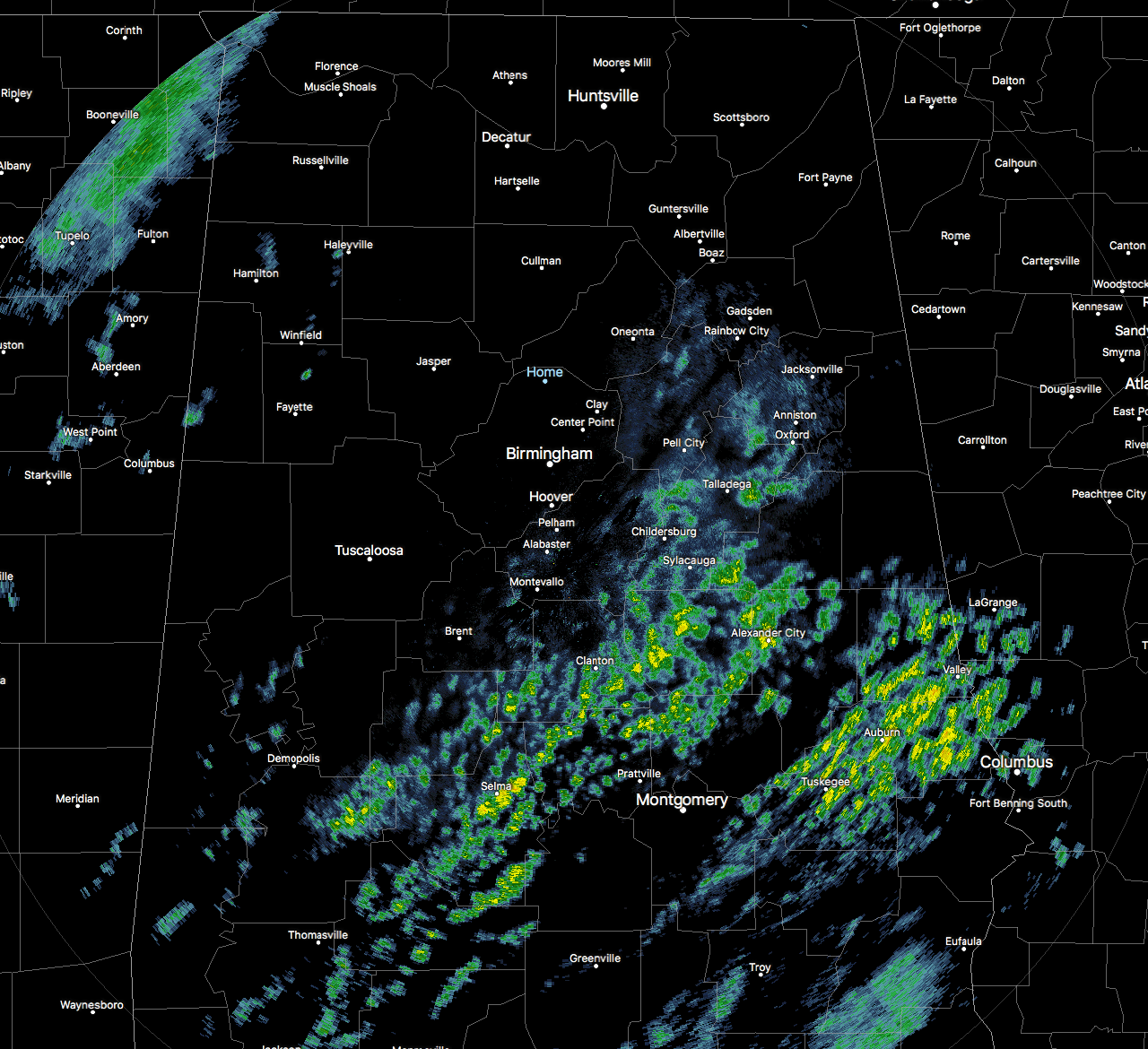
Scattered showers are moving across the southern half of the area at the midday hour, but more rain is likely during the afternoon and evening hours tonight. Skies are currently cloudy where the rain is not falling at this point.
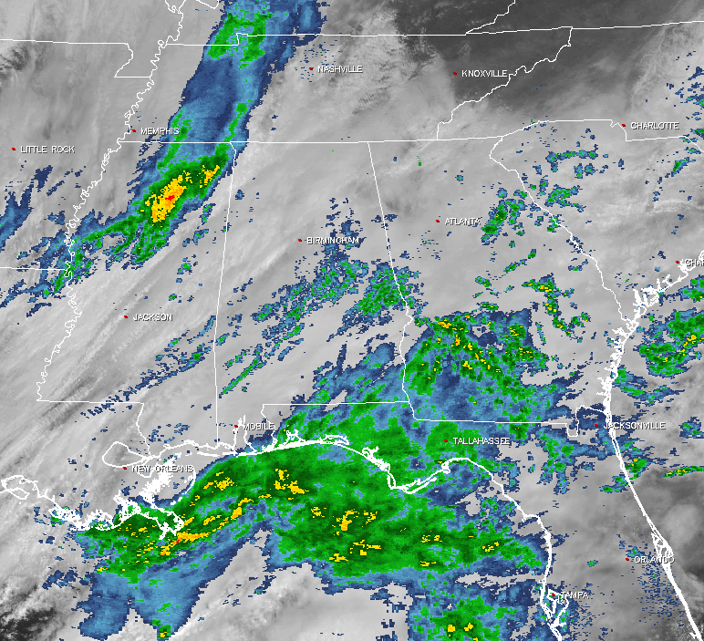
Looking back to our west, you can see a mass of rain in the northern half of Mississippi that will make its way into the state within the next hour or so. We also have plenty of showers across the Gulf Coast and up into the panhandle of Florida and up into the southern parts of Alabama and Georgia.
FOR THE REST OF YOUR MONDAY
The main line of showers will start to move into the northwestern locations of Central Alabama around the 12PM-1PM time frame, and move into the Tuscaloosa and Birmingham areas between 4PM-6PM. The line should reach the Gadsden and Anniston areas by the 5PM-7PM time frame, and move completely out of the state and into Georgia right after midnight tonight. There will be some scattered showers out ahead of the main line, but skies will remain cloudy otherwise. Afternoon highs will be in the upper 40s to the mid 50s across Central Alabama. Lows tonight will fall into the upper 30s to the lower 40s.
TEMPERATURES ACROSS CENTRAL ALABAMA
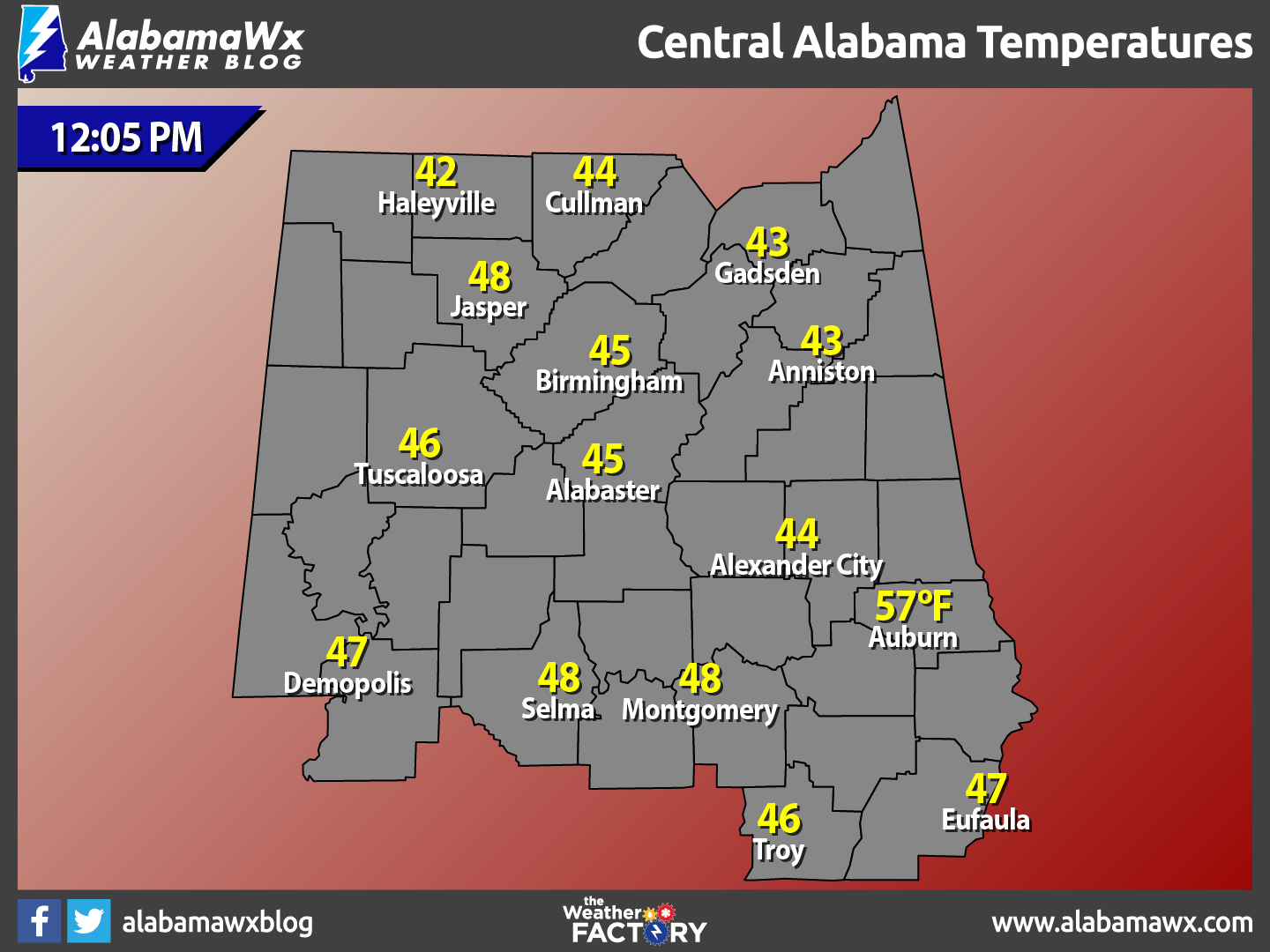
At 12:05 PM, temperatures are ranging from the lower 40s in the northern parts of Central Alabama, to the upper 40s to the south. The warm spots are currently Montgomery and Selma at 48ºF, with the cool spot being Haleyville at 42ºF.
BREEZY AND COLD FOR TUESDAY
We’ll have a little bit of wrap around moisture on the back side of the system passing through, and a few sprinkles or even a few snow flurries could be possible over the northern parts of Central Alabama. Skies will remain mostly cloudy throughout the day, and afternoon highs will make it into the mid 40s to the mid 50s across the area from north to south. Winds will be out of the northeast at 5-15 MPH, with gusts up to 20 MPH, so bundle up when heading out. Skies will begin to clear out during the overnight hours, and combined with decreasing winds, temperatures will drop to below freezing area wide, mid 20s to right at 30 degrees from north to south. A freeze warning will likely be issued.
WHAT TO EXPECT AT THE BEACH
For a detailed look at the weather from Fort Morgan over to Panama City Beach, click here to see a on our Beach Forecast Center page. Save Up To 25% on Spring Break Beach Vacations on the Alabama Gulf Coast with Brett/Robinson! The Beach Forecast is partially underwritten by the support of Brett/Robinson Vacation Rentals in Gulf Shores and Orange Beach. Click here to see Brett/Robinson’s best beach offers now!
CLIMATOLOGY AND RECORDS FOR BIRMINGHAM
The normal high for March 13th is 66ºF, while the normal low is 42ºF. The record high for today was set back in 1900 at 84ºF. The record low was set back in 1993 at 12ºF.
TODAY IN WEATHER HISTORY
March 13, 1993: It will be a day that will go down as a once-in-a-generation event, as every county in the state of Alabama had snow cover from the “Blizzard of 93.” In Central Alabama, snow totals ranged from 4-5 inches in the southern parts of the area, to 20 inches in the extreme northeastern parts of the area. Snow drifts in some locations reach unbelievable depths of 5 to 6 feet. The coldest low temperature ever recorded in Birmingham for the month of March happened on the night of the 13th and into the morning of the 14th, when the mercury dipped down to 2 degrees.
WEATHERBRAINS
This week’s show will be about the tropics. The “Brains” will welcome Dr. Phil Klotzbach, a Research Scientist in the Department of Atmospheric Science at Colorado State University. Klotzbach has been employed in the Department of Atmospheric Science for the past fifteen years where he has been co-author on the Atlantic basin hurricane forecasts with Dr. William Gray. He became first author on the seasonal hurricane forecasts in 2006. Klotzbach developed the two-week forecasts currently being issued during the peak months of the hurricane season between August-October. He developed the Landfalling Hurricane Probability Webpage (available online at https://www.e-transit.org/hurricane) in partnership with the GeoGraphics Laboratory at Bridgewater State University. This webpage provides hurricane landfall probabilities for the entire United States coastline from Brownsville, Texas to Eastport, Maine as well as the Caribbean. He has published over two dozen articles in peer-reviewed journals such as Journal of Climate, Weather and Forecasting, and Geophysical Research Letters.
You can catch this week’s show on WeatherBrains website, or on the James Spann 24/7 channel on cable or on the dot 2 feed.
Subscribe to the podcast on iTunes
THE BLOG IS ON SOCIAL MEDIA
@AlabamaWxBlog on Facebook
@AlabamaWxBlog on Twitter
WANT TO ADVERTISE ON THE ALABAMAWX WEATHER BLOG
Deliver your message to a highly engaged audience by advertising on the newly reformatted AlabamaWX.com website. The site enjoyed 10.2 MILLION page views in the past 12 months. Don’t miss out! We can customize a creative, flexible and affordable package that will suit your organization’s needs. Contact Bill Murray, at (205) 687-0782.
Category: Alabama's Weather, ALL POSTS
About the Author (Author Profile)
Scott Martin is an operational meteorologist, professional graphic artist, musician, husband, and father. Not only is Scott a member of the National Weather Association, but he is also the Central Alabama Chapter of the NWA president. Scott is also the co-founder of Racecast Weather, which provides forecasts for many racing series across the USA. He also supplies forecasts for the BassMaster Elite Series events including the BassMaster Classic.Subscribe
If you enjoyed this article, subscribe to receive more just like it.


