Midday Nowcast: A Few Flurries; Freeze Warnings Tonight and Tomorrow Night
BREEZY, NOT BEAUTIFUL, AND YOU’LL NEED COVERS GIRL
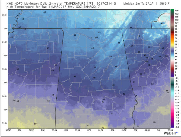
That headline is what I told my wife this morning after I wheeled my garbage can out to the street at 7:30 this morning. I thought I could take the trash out before getting cold… and boy, was I wrong! Temperatures are still in the 30s over North Alabama. The rest of Central Alabama was struggling through the 40s with brisk winds our of the northwest bringing in cold air. Winds were averaging some 10-18 mph with occasional gusts to 25-30 mph. Wind chill values over the Tennessee Valley are below freezing.
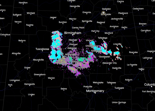
Hydrometeor classification algorithm showng a little dry snow over Central Alabama
FEW FLURRIES
As we advertised since the weekend, a few snow flurries have been showing up across North Alabama. Flurries were reported at Russellville. There have been numerous reports of them in southern Tennessee as well. Sleet was reported in Lawrence County, probably actually snow pellets. Radar shows what may be flurries over southern Walker, southwestern Jefferson, Tuscaloosa, Chilton and Bibb Counties as well as Talladega and Clay Counties in East Alabama. Won’t cause any problems though.
COLD ALOFT
Temperatures at the surface may be in the 40s in the I-20 Corridor, but they quickly go below freezing less than 3,000 feet above the surface, making the flurries possible.
AIN’T NO SUNSHINE
North Alabama is socked in with lots of thick cloudiness, helping to keep those temperatures down. And there is lots of thick cloudiness upstream as well. South of I-20, there was some sunshine as a few breaks in the clouds have opened up. Sunshine begats more sunshine in these situations as the solar radiation heats the boundary layer and helps to evaporate the clouds. But with cold temperatures making for some instability, lots of stratocumulus will fill back in through the afternoon. Skies will not completely clear even overnight tonight. It will be tomorrow morning.
WIDESPREAD FREEZE AHEAD
These are NWS forecast temperatures tonight:
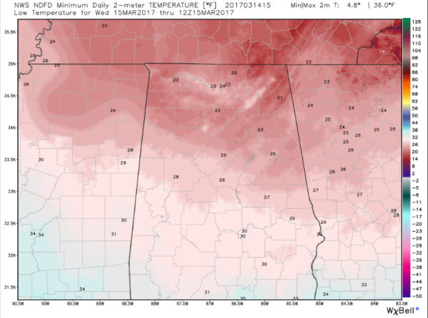
And this is with partly cloudy skies and winds that will likely not go calm. So it could be even worse. If skies do manage to clear and winds can go calm in protected locations, even colder readings will be possible. There will be some teens in some of the normally colder locations.
FREEZE WARNING TONIGHT
The NWS maintains a freeze warning for tonight for all of North and Central Alabama. Protect tender vegetation that would be damaged by a widespread killing freeze.
NO BETTER TOMORROW
I am afraid tomorrow and tomorrow night won’t be any better, despite increasing amounts of sunshine. Highs will not get out of the 40s again tomorrow over the northern half of Alabama.
And a freeze warning is already posted for tomorrow night for North and Central Alabama. Lows tomorrow night should look a lot like tonight’s, although I fear it could be a degree or two colder with lighter winds. But skies will be partly cloudy still which will help.
END OF THE WEEK/WEEKEND
Thursday looks dry and cool. Friday features a warm up, but at a cost. After a nice day Friday, showers return late Friday night and continue into Saturday. Sunday looks nice with highs in the 60s. Monday looks even nicer with highs in the 70s again. It will feel like a tropical heat wave!
Category: Alabama's Weather, ALL POSTS
About the Author (Author Profile)
Scott Martin is an operational meteorologist, professional graphic artist, musician, husband, and father. Not only is Scott a member of the National Weather Association, but he is also the Central Alabama Chapter of the NWA president. Scott is also the co-founder of Racecast Weather, which provides forecasts for many racing series across the USA. He also supplies forecasts for the BassMaster Elite Series events including the BassMaster Classic.Subscribe
If you enjoyed this article, subscribe to receive more just like it.


