A Few Sprinkles Out There At Midday, But At Least It Is Warmer
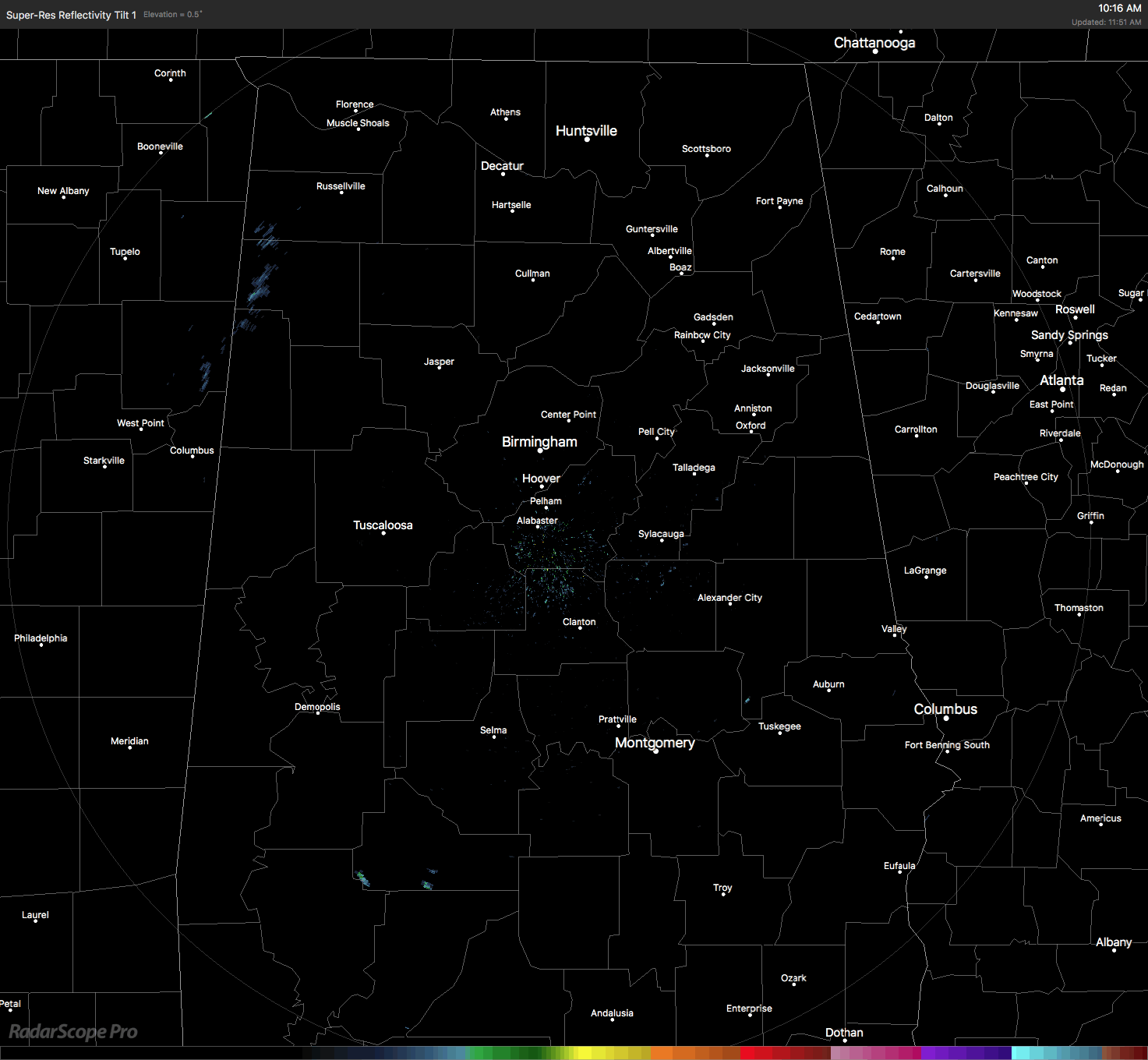
We actually have a few sprinkles showing up on radar in the northwestern parts of the area… especially in parts of Marion, Winston, Lamar, and Fayette counties.
It’s a mostly cloudy day across much of Central Alabama at the midday hour, but the sun is shining in the extreme southern portions of the area. Some of the cloud cover to the south may actually erode away throughout the afternoon hours, while the clouds will be hanging tough for the northern half.
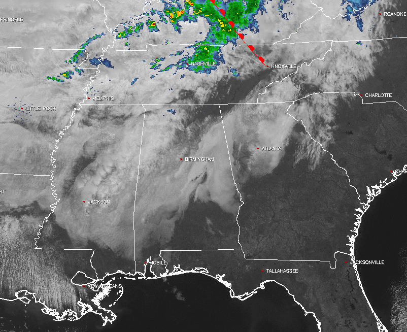
Up to our north is a broken line of showers moving through portions of Kentucky and down into Tennessee. This line is expected to move into the northern parts of the area after midnight tonight.
Temperatures Across Central Alabama
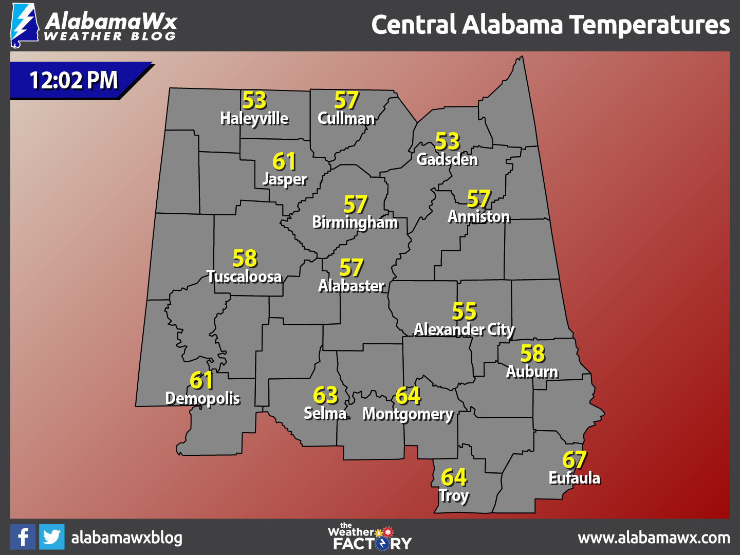
Temperatures are currently ranging from the lower 50s across the northern parts of the area, to the upper 60s in the south. The warm spot is currently Eufaula at 67ºF, while the cool spots are Haleyville and Gadsden at 53ºF.
Average Temperatures And Records For March 17th
Average daytime high for Birmingham for today is 67ºF, while the average low is 43ºF. The record high was set back in 1963 when the mercury hit an impressive 86ºF. The record low was recorded at 28ºF back in 1988.
For the Rest of Your Friday
Skies will remain mostly cloudy across much of Central Alabama for the remainder of the daylight hours, while some clouds could erode away in the southern portions of the area. A few sprinkles are possible in the northwestern parts of the area, but most of the area should remain dry. Afternoon highs will be in the mid 60s to the lower 70s across the area. Skies will be mainly cloudy for much of the area tonight with showers and a few thunderstorms likely after midnight. Overnight lows will be in the upper 40s to the upper 50s.
Showers and a Few Thunderstorms Likely for Saturday
From the daybreak hours through the morning hours, showers and a few thunderstorms are possible mainly across the northern half of Central Alabama (north of the I-20 corridor). As the surface front moves to the south, shower activity should diminish for the afternoon hours, and temperatures should rebound into the low to mid 70s for afternoon highs. Skies will clear out for Saturday evening, and the night will be nice. Overnight lows will drop into the upper 30s to the mid 40s.
What To Expect At The Beach
For a detailed look at the weather from Fort Morgan over to Panama City Beach, click here to see our Beach Forecast Center page. Save Up To 25% on Spring Break Beach Vacations on the Alabama Gulf Coast with Brett/Robinson! The Beach Forecast is partially underwritten by the support of Brett/Robinson Vacation Rentals in Gulf Shores and Orange Beach. Click here to see Brett/Robinson’s best beach offers now!
Today In Weather History: March 17, 1990
Showers and thunderstorms associated with a slow moving cold front produced torrential rains across parts of the southeastern U.S. over a two day period. Flooding claimed the lives of at least 22 persons, including thirteen in Alabama. Up to 16 inches of rain deluged southern Alabama, with 10.63 inches reported at Mobile AL in 24 hours. The town of Elba AL was flooded with 6 to 12 feet of water causing more than 25 million dollars damage, and total flood damage across Alabama exceeded 100 million dollars. Twenty-six counties in the state were declared disaster areas.
WeatherBrains
No, there were no naked people on this week’s edition of WeatherBrains, but we did have a great discussion about nor’easters and tropical weather. Our guest “Brain” was Dr. Phil Klotzbach, a Research Scientist in the Department of Atmospheric Science at Colorado State University. We also had Dakota Smith from “The Weather Junkies” as a guest panelist. Dakota is a atmospheric science graduate student studying the carbon cycle at Colorado State University. You can catch this week’s show on these outlets:
Big Brains Media website
WeatherBrains website
Subscribe to the podcast on iTunes
The Blog Is On Social Media
@AlabamaWxBlog on Facebook
@AlabamaWxBlog on Twitter
Want To Advertise on The Alabama Wx Weather Blog
Deliver your message to a highly engaged audience by advertising on the newly reformatted AlabamaWX.com website. The site enjoyed 10.2 MILLION page views in the past 12 months. Don’t miss out! We can customize a creative, flexible and affordable package that will suit your organization’s needs. Contact Bill Murray at (205) 687-0782.
Category: Alabama's Weather, ALL POSTS
About the Author (Author Profile)
Scott Martin is an operational meteorologist, professional graphic artist, musician, husband, and father. Not only is Scott a member of the National Weather Association, but he is also the Central Alabama Chapter of the NWA president. Scott is also the co-founder of Racecast Weather, which provides forecasts for many racing series across the USA. He also supplies forecasts for the BassMaster Elite Series events including the BassMaster Classic.Subscribe
If you enjoyed this article, subscribe to receive more just like it.


