Dry but Coolish Day, Warmer Monday
.
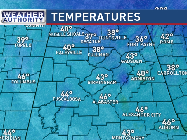
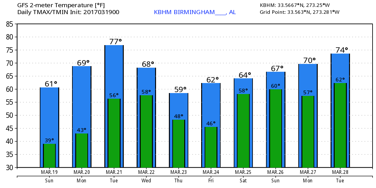
After a chilly start to the day, I expect to see mostly sunny skies with highs climbing into the lower and middle 60s across Central Alabama. Some clouds tonight will temper the radiational cooling as lows fall back into the lower 40s, upper 30s in the normally colder valley locations. Monday should be another nice day as the upper ridge becomes the main player in our weather pattern. Highs will jump back into the 70s.
A strong trough moving across southern Canada will drag a weak front into the Ohio River Valley on Tuesday. With the surface high positioned over the Northeast Gulf, our temperatures will be warm with highs in the upper half of the 70s with locations south of Birmingham toying with the 80 degree mark. With only a little push from the flow aloft, the weak frontal zone is forecast to sag into Central Alabama. The primary evidence of the frontal zone will be the potential for isolated showers with the potential for a little thunder to be heard. Most of us stay dry. Temperatures will fall back slightly on Wednesday with highs around 70. It will be a little cooler on Thursday with highs in the 60s but we dry out.
Thursday we start watching the approach of a strong upper trough coming across the southern and central Rockies. The trough axis will extend from southern Minnesota to North Central Texas on Friday. As our surface flow comes around to the south, we’ll probably have to mention a small chance of showers. SPC has outlined a 15 percent area for severe storms on Day 6 over a large part of Arkansas, eastern Oklahoma, Northeast Texas, and Northwest Louisiana in association with this system. For us, highs will climb back into the upper 60s on Friday.
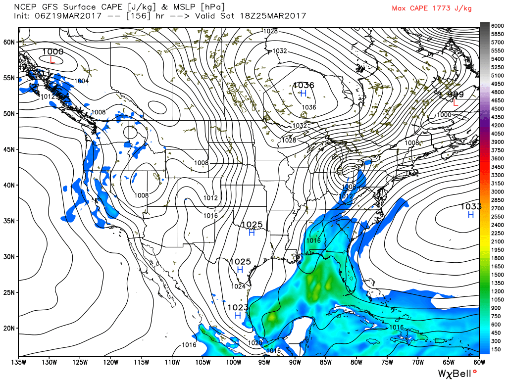
Saturday should begin somewhat stormy as the upper trough makes its way across the Southeast US. This run of the GFS is a tad faster than what we saw yesterday with thunderstorms coming through Central Alabama in the first half of Saturday, primarily between about 1 am and 1 pm. Some clearing is likely to occur by the afternoon on Saturday. Highs will be in the 60s. Just as we saw yesterday, the GFS still maintains a substantial amount of instability with CAPE values ranging from 1200 to 1600 j/kg, but the shear shown on the helicity charts remains offset and well ahed of the instability. With the two parameters offset, confidence in a severe event is not high. However, this could be one of those high CAPE/low shear events. So we’ll continue to monitor future model runs to see how this system evolves.
The upper trough moves across the East Coast on Sunday as we come quickly under an upper ridge. Looks like temperatures won’t change a great deal with highs by Sunday around the 70-degree mark.
For a detailed look at the weather from Fort Morgan to Panama City Beach, click here to see the Beach Forecast Center page. Save Up To 25% on Spring Break Beach Vacations on the Alabama Gulf Coast with Brett/Robinson! The Beach Forecast is partially underwritten by the support of Brett/Robinson Vacation Rentals in Gulf Shores and Orange Beach. Click here to see Brett/Robinson’s best beach offers now!
Looking out into voodoo country, there is not much to be surprised at as the GFS keeps a steady stream of weather systems coming at us as we enter the first of April. The one on the 3rd of April looks particularly strong with the look of a potential severe weather episode for the southern states.
I enjoyed filling in for Meaghan Thomas on ABC 3340 last night. Meaghan will be back for the news at 5 and 10 pm today. James Spann will have the next edition of the Weather Xtreme Video on Monday morning. Stay tuned to the blog for notes on the Alabama weather situation. Enjoy the day and Godspeed.
-Brian-
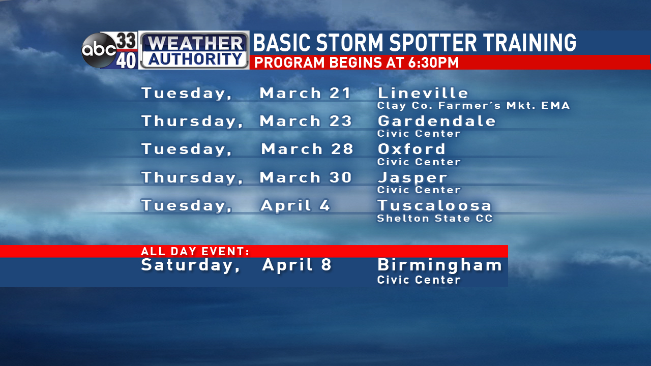
Don’t forget our storm spotter training schedule continues in full swing over the next three weeks.
Category: Alabama's Weather, ALL POSTS
About the Author (Author Profile)
Brian Peters is one of the television meteorologists at ABC3340 in Birmingham and a retired NWS Warning Coordination Meteorologist. He handles the weekend Weather Xtreme Videos and forecast discussion and is the Webmaster for the popular WeatherBrains podcast.Subscribe
If you enjoyed this article, subscribe to receive more just like it.


