Stormy Pattern Continues
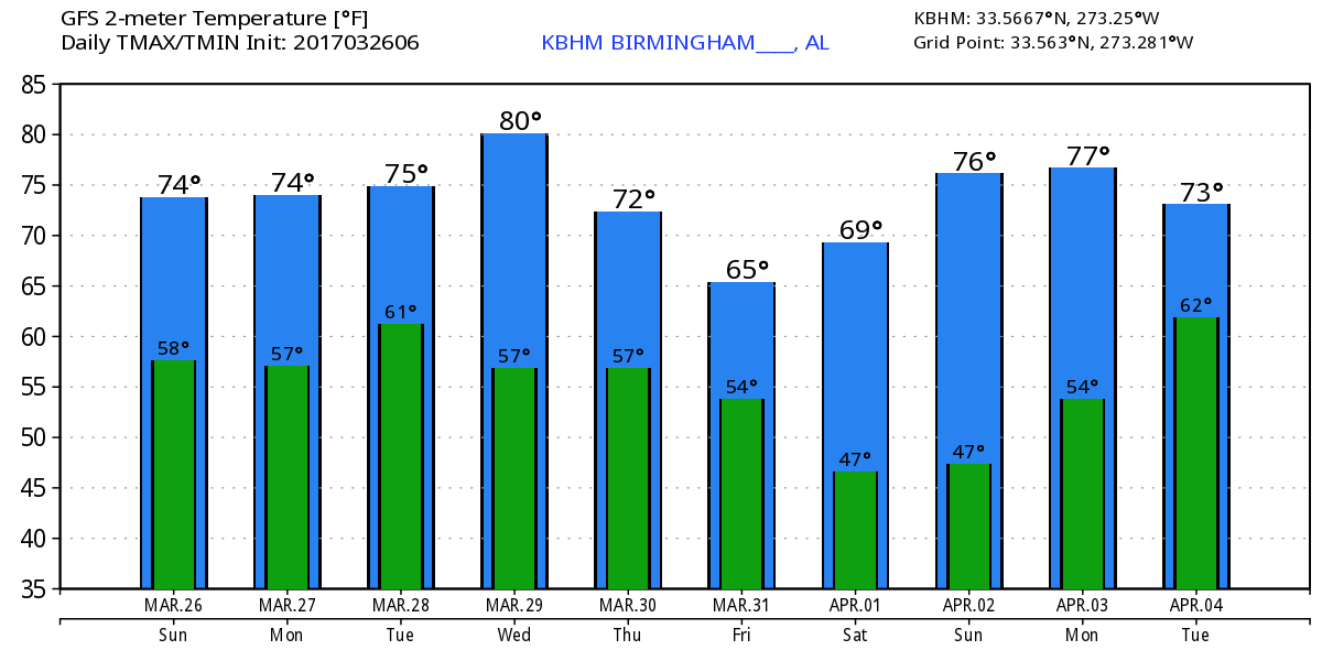
Much of Alabama saw a line of thunderstorms move by on Saturday. Fortunately, conditions did not deteriorate enough to produce severe storms, but most places saw between 1 and 2 inches of rain. That will surely help put another dent in the lingering drought conditions. clouds cover much of the Southeast US this morning. With the absence of a frontal passage and the continuation of southerly flow, we will remain somewhat unstable today with the potential for a few showers in a somewhat summer-like setup. Highs will be in the middle 70s.
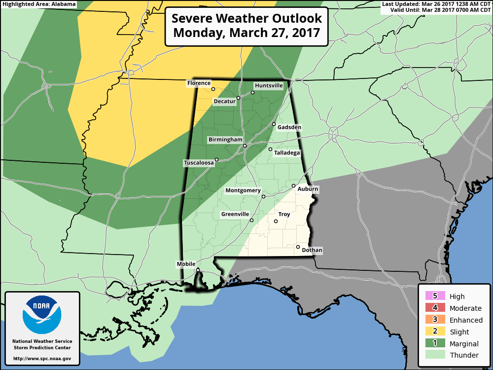
The upper trough that produced the line of storms yesterday will move up into New England Monday as another strong short wave moves across the Central Mississippi River Valley. SPC has the standard slight risk over a large section of the Mid-South on Monday, Day 2. The edge of the slight risk area catches Northwest Alabama with about the northwestern half of the state in a marginal risk area. Hail is likely to be the biggest threat, but wind fields over the northern portion of the slight risk area indicate the potential for damaging wind and isolated tornadoes. Temperatures Monday will climb well into the 70s for highs. Monday afternoon and evening we could see some strong storms while the biggest threat area remains northwest of us.
An upper ridge promises some good weather – read that as an absence of storms – for Tuesday and Wednesday. The GFS appears to be a little slow on moving the showers out of here on Tuesday, but I think we should be mainly dry both days. You can expect to see highs in the upper half of the 70s once again.
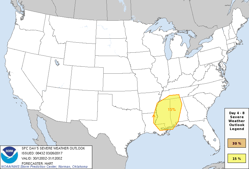
But don’t let the good weather of midweek lull you into a false sense of euphoria. Wednesday we begin watching another potent system over the Texas Panhandle that will move to the ArkLaTex on Thursday. SPC has outlined a large area including the western two-thirds of Alabama and about all of Mississippi for Day 5, Thursday. The surface low will be in North Central Arkansas moving east-northeastward across the Mid-South region. This is likely to produce CAPE values in the range of 2400 to 3000 j/kg for Thursday afternoon and evening along with shear values for storm relative helicity in the range of 300 to 400. So, we could see a substantial round of severe storms for the latter half of Thursday.
Friday will be a day for improving weather as the system aloft moves into the eastern Ohio River Valley and the surface low moves to Ohio. Highs will dip back a little with readings in the upper 60s. A nice ridge aloft promises a Saturday to enjoy with highs back in the 70s and dry weather. Since the upper ridge sticks around on Sunday, it will also be a nice day though clouds may be more prevalent as we begin watch yet another closed low over the southern Rockies on Sunday that poses another round of severe storms across the Southeast US on Tuesday, April 4th! This is definitely into voodoo country, so no specific severe weather forecast just yet. But the pattern is certainly suggestive of a substantial severe weather situation. So we’ll keep a wary eye on how this system evolves with future model runs.
The GFS maintains an active pattern through week 2 with yet another upper closed low for the Lower Mississippi River Valley on the 7th of April. This one looks especially interesting as the closed low is forecast to dig into North Florida by the 8th of April. And you know one of the mantras around here – cold core upper low, weatherman’s woe! See the video for the graphic showing the temperature anomaly with this system. That one clears the Southeast US coast by the 10th as we watch another strong trough coming out of the Rockies. Definitely not underselling anything when we say the pattern is active!
The beach weather looks stormy through midweek, but still periods of good weather for a little beach time. Lows will be in the lower 60s with highs in the middle and upper 70s. For a detailed look at the weather from Fort Morgan to Panama City Beach, click here to see the Beach Forecast Center page. Save Up To 25% on Spring Break Beach Vacations on the Alabama Gulf Coast with Brett/Robinson! The Beach Forecast is partially underwritten with the support of Brett/Robinson Vacation Rentals in Gulf Shores and Orange Beach. Click here to see Brett/Robinson’s best beach offers now!
The ABC 33/40 Weather Authority Team will be on the road through early April offering free storm spotter classes. We need more trained spotters in Alabama. By attending, you can make the severe weather warning process better. No registration required, just come with a curious mind. There is no age limit. Kids that love weather will enjoy it. You will never look at a storm the same again. Next week the team is scheduled to be at Oxford on Tuesday at the Oxford Civic Center and Jasper on Thursday at the Jasper Civic Center.
James Spann will have the next Weather Xtreme Video here first thing Monday morning. With the stormy pattern ahead, I’m going off the grid later this morning in hopes of resting up for what the atmosphere throws at us over the next two weeks! Be safe and Godspeed.
-Brian-
Category: Alabama's Weather, ALL POSTS
About the Author (Author Profile)
Brian Peters is one of the television meteorologists at ABC3340 in Birmingham and a retired NWS Warning Coordination Meteorologist. He handles the weekend Weather Xtreme Videos and forecast discussion and is the Webmaster for the popular WeatherBrains podcast.Subscribe
If you enjoyed this article, subscribe to receive more just like it.


