Beautiful Today, Severe Threats Tomorrow and Wednesday
GORGEOUS SUNDAY HERE: The day dawned bright and seasonably mild across Central Alabama with lows in the upper 40s and lower 50s. Temperatures have warmed quickly under mostly sunny skies and were approaching 80F in the I-20 Corrdior. Blowoff from the tops of thunderstorms over Louisiana was bringing some high cirrus to parts of the area. High pressure centered along the Pennsylvania/Ohio border continues to influence our weather. The airmass across Alabama continues to be very dry, with precipitable water values less than one half inch, which is dry even by early April standards.
CHANGES ON THE WAY: A deep upper level trough is over western Texas and New Mexico early this afternoon. A surface low is along the Central Texas Coast. A low level jet is developing over Louisiana, pumping huge amounts of moisture into the Central Gulf Coast. Severe weather is likely across areas to the west of Alabama this afternoon and overnight. The bullseye for severe weather will be across eastern Texas, Louisiana, southern Arkansas and western Mississippi.
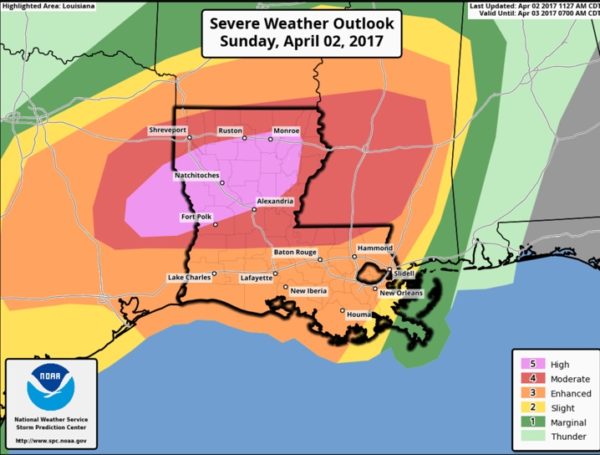
HIGH RISK: The SPC has posted a high risk Severe Weather Outlook across Northeast Texas and northern Louisiana where there is a 30% chance of EF2 or greater tornadoes within 25 miles any given location. Tornado watches are already in effect across Louisiana and eastern Texas. The storms to our west will congeal into a line of storms and will be impacting Alabama late tonight and Monday.
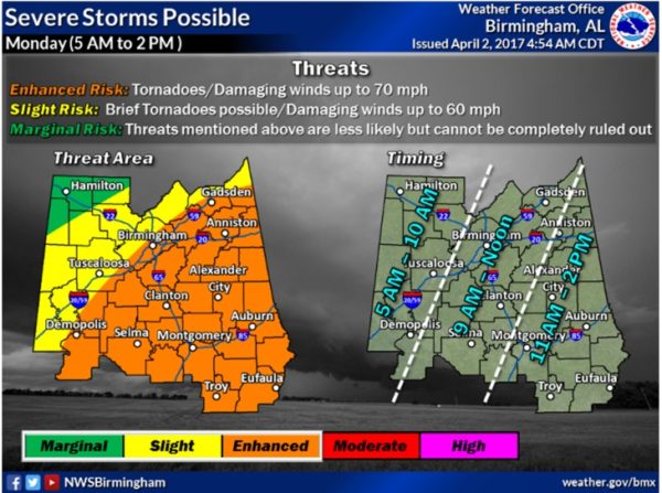
TIMING: The first wave of storms should reach the Mississippi River around 6 p.m. but weaken as it crosses the state of Mississippi. Some storms could reach Northwest and West Central Alabama before midnight however, they shouldn’t be severe. The main activity should reach West Central Alabama by 5 a.m., affecting the Birmingham area between 9 a.m. and noon and eastern Alabama between 11 a.m. and 2 p.m.
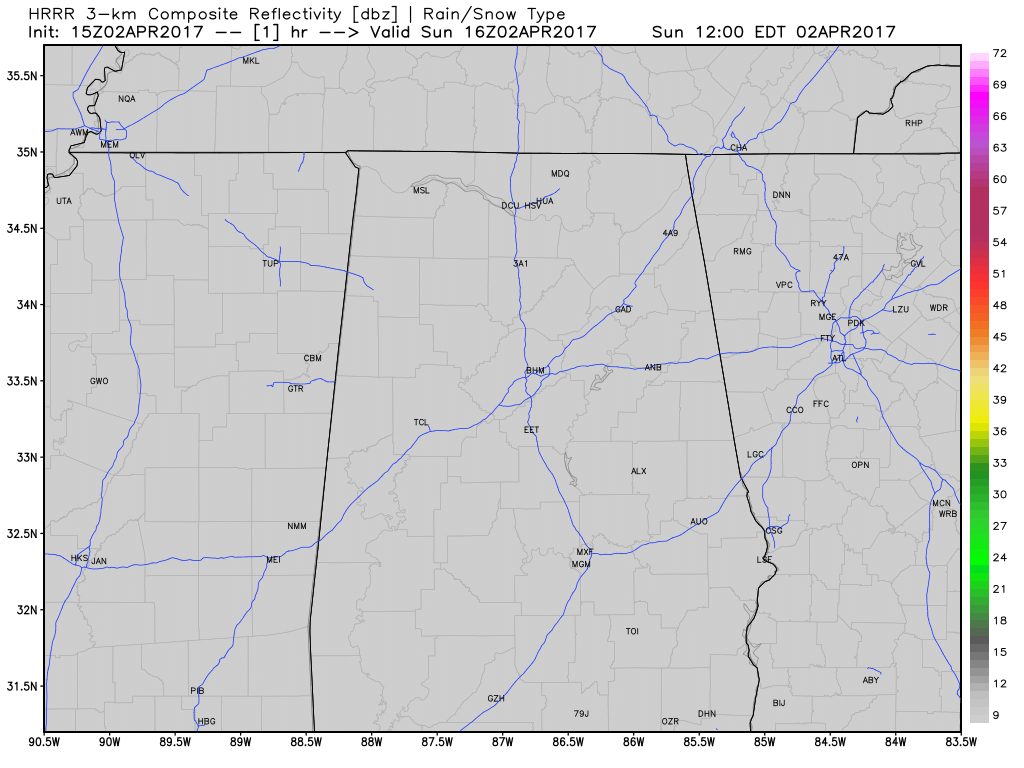
Here is the HRRR depiction the overnight storms approaching Alabama:
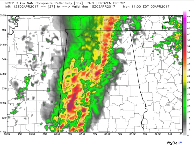
Here is the WRF model’s radar reflectivity depiction at 10 a.m. CDT:
THE THREATS: The upper level pattern will be conducive to maintaining the storms’ strengthen as they push into Alabama, despite the fact that they will be arriving during the morning hours. The upper trough actually strengthens through the morning, which is worrisome. Damaging winds will be the primary threat for areas northwest of I-59, but for areas southeast of I-59, brief tornadoes are also possible.
AFTERNOON RE-DEVELOPMENT: Some showers and thunder will redevelop during the afternoon over eastern Mississippi and push into Alabama during the late afternoon and evening, but this activity is not expected to be heavy or widespread and no additional severe weather is expected late Monday afternoon or evening.
BE WEATHER AWARE: Monitor the thunderstorms as they move into Alabama during the early morning hours and progress across the state during the day. As we always say, review your severe weather safety plan and have a reliable way to receive warnings. Have a safe place to go if a severe thunderstorm or tornado warning is issued for your location.
TUESDAY: Much of this day will be fine as we will be in between systems. We are forecasting a day a mainly sunny sky and highs in the upper 70s and lower 80s. We note much of South Alabama has been highlighted in a “marginal risk” for severe storms on Tuesday, but this will be for the overnight hours as a warm front lifts north, and a few strong and possibly severe storms will develop during the overnight hours.
WE NEED TO GET THROUGH THE MONDAY SYSTEM BEFORE WORRYING ABOUT WEDNESDAY, BUT…Wednesday looks like a day that we will have to worry about. It appears there will be a 995 mb surface low over southern Illinois at noon on Wednesday with a strong 125 knot jet stream over northern Mississippi. Instabilities along and east of I-65 will be in the 1,000-2,5000 joules range, which is substantial, and 50 knots of wind shear will make the storms organized. It appears to me that the greatest threat will be east of I-65 and south of I-85, but if the system is slower to arrive, it could allow more of Alabama to get into a more volatile airmass ahead of the approaching system and we could deal with a significant risk of tornadoes. The SPC has most of Alabama highlighted in the threat for severe storms in its Day Four Outlook.
Category: Alabama's Weather, ALL POSTS
About the Author (Author Profile)
Bill Murray is the President of The Weather Factory. He is the site's official weather historian and a weekend forecaster. He also anchors the site's severe weather coverage. Bill Murray is the proud holder of National Weather Association Digital Seal #0001 @wxhistorianSubscribe
If you enjoyed this article, subscribe to receive more just like it.


