Rain and Thunder Moving in Quicker Than Expected
The mass of rain across Mississippi is moving into Alabama faster than expected tonight, overwhelming the dry airmass that is in place.
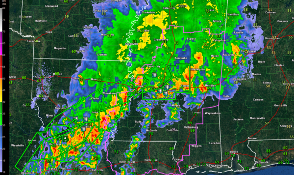
At 10:15 p.m., thunderstorms with heavy rain and lots of lightning were over much of Pickens, northern Sumter and Greene Counties, moving into Tuscaloosa and Hale Counties.
More rain and thunder is over Marion, Lamar and Fayette counties.
The good news is that the airmasss over Alabama is pretty stable.
Rain and storms continue to affect much of Mississippi. Winds at 18,000 feet are increasing over Louisiana and Mississippi and this is helping the rain and storms to expand.
There are no severe thunderstorm warnings in Mississippi or Louisiana right now, but there are many flash flood and flood warnings. It appears to me that the area of rain and storms is becoming parallel to the low-level, mid-level and upper-level flows tonight. This could mean some very heavy rains across Louisiana and Mississippi that could work into Alabama overnight.
Fort Polk LA has picked up 9.30 inches so far and Fulteron LA in Vernon Parish has reached 9.74 inches. In Alexandria, 8.36 inches of rain has fallen over the past nine hours. Water is now in homes and many roads in the City of Alexandria are underwater. A firehose of moisture is pointing into Central Louisiana and more rain is on the way. This could become a serious flooding situation overnight.
In Mississippi, there are numerous reports of flooding in and around Jackson MS.
The airmass south of the area of rain and storms is extremely moist. There is strong mid and low level flow over Mississippi. There will continue to be a severe weather threat along the southern flank of this area of rain and storms overnight. This will gradually push into Alabama through the early morning hours. The main threat will be damaging winds but an isolated tornado is not out of the question.
Category: Alabama's Weather, ALL POSTS
About the Author (Author Profile)
Bill Murray is the President of The Weather Factory. He is the site's official weather historian and a weekend forecaster. He also anchors the site's severe weather coverage. Bill Murray is the proud holder of National Weather Association Digital Seal #0001 @wxhistorianSubscribe
If you enjoyed this article, subscribe to receive more just like it.


