

Rain, Thunder Continue; No Warnings for Central Alabama at the Time
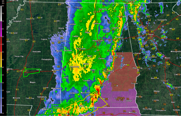
Radar data is flowing again from BMX. And it shows a line of storms from Fort Payne in Northeast Alabama to Anniston and Talladega to Rockford, Wetumpka, Hayneville, Georgiana and Brewton. From there is curves back into the Mobile area, which is getting pounded right now. Flash flood warnings are in effect for the City of Mobile.
A long severe thunderstorm warning continues from Coneuch and Escambia Counties back through Mobile and Baldwin Counties.
A large area of moderate to heavy rain covers areas west of I-65. It is not moving very much. There are a few rubles of thunder in it as well.
Robert Christian reports 3.25 inches of rain in the Norwood community north of downtown Birmingham. 2.66 inches at the Airport so far.
There have been scattered reports of flooding in and around the Birmingham metro, but no flood advisories or warnings for Central Alabama. Turn around, don’t drown if you see a flooded roadway!
The severe thunderstorm watch continues for Barbour, Bullock, Chambers, Coosa, Elmore, Lee, Lowndes, Macon, Montgomery, Pike, Russell and Tallapoosa Counties till 11:00 AM CDT. Otherwise, the severe threat has ended for Central Alabama.
A couple of tornado watches are in effect for South Alabama.
Category: Alabama's Weather, ALL POSTS
About the Author (Author Profile)
Bill Murray is the President of The Weather Factory. He is the site's official weather historian and a weekend forecaster. He also anchors the site's severe weather coverage. Bill Murray is the proud holder of National Weather Association Digital Seal #0001 @wxhistorianSubscribe
If you enjoyed this article, subscribe to receive more just like it.


