Potentially Dangerous Situation Tomorrow
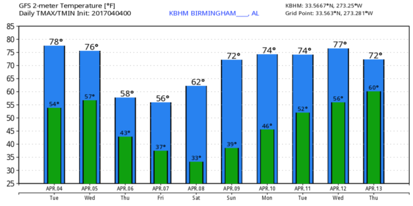
NO ISSUES TODAY: About the only problem today is dense fog this morning over parts of Central and South Alabama… that will dissipate by mid morning, and the day will be sunny and warm with a high in the low 80s.
Clouds move in tonight, and showers and storms are possible as early as 4:00 a.m. tomorrow as moist air rapidly moves northward. SPC has much of the state in a severe weather risk for this activity in their “Day One” outlook, which runs through 7am tomorrow. For North/Central Alabama, the main risk with the early morning storms will most likely come from hail and strong winds, highest tornado threat early tomorrow will be over Southwest Alabama.
TOMORROW: A surface low will be south of St. Louis, supported by a strong upper trough (the last in the series with this “wave train”) with strong wind fields. The large scale pattern is certainly favorable for severe weather across Alabama, but the small scale features will determine the magnitude of the event.
Instability values will rise rapidly during the day, and surface based CAPE values will be in the 3,000 to 4,000 j/kg range by afternoon, making for a “power keg” type atmosphere as the spring storm system approaches. Forecast shear profiles favor severe storms as well; SPC has now put parts of East and South Alabama in a “moderate” risk, with an “enhanced risk” for much of the rest of the state.
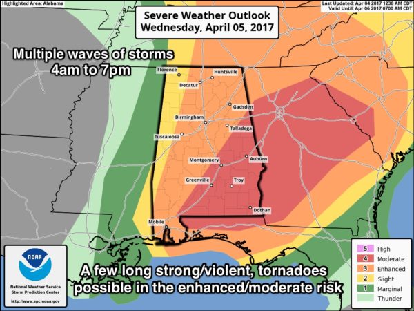
It is important not to get too hung up in risk areas and lines on these maps; remember storms don’t know anything about those lines and terms. This is simply a guideline to let you know where the greatest risk will be. Could there be an upgrade to a high risk in later outlooks today? Yes, but it just isn’t that important. Just be ready one way or another.
PLACEMENT: While all of Alabama has a severe weather risk tomorrow, the highest tornado potential will come from roughly I-65 east, or over the eastern half of the state. This is where the best combination of lift, instability, and shear will be found. Understand a tornado is certainly possible over West Alabama, but the odds are a bit lower there.
TIMING: Best thing we can say for now is that we expect multiple waves of thunderstorms from 4:00 a.m. until 7:00 p.m. The highest threat of tornadoes will come during the afternoon/evening hours, during the peak of the daytime heating process. More than likely, there will be lull in the action during the midday hours, but even then a few severe storms will be possible. We will need to be vigilant through the entire day.
THREATS: All modes of severe weather will be possible tomorrow, including large hail, damaging straight line winds, and tornadoes. A few long track, strong/violent tornadoes are possible, especially in the “enhanced” and “moderate” risk areas defined by SPC on the map above.
RAIN: Rain amounts around one inch are likely; no flooding issues are expected.
CALL TO ACTION: Be sure you have a way of getting warnings; a NOAA Weather Radio is the baseline, and a good smart phone app is the other tier. Identify the safe place in your home, and be sure everyone knows where it is. And, in that safe place have helmets for everyone, along with hard sole shoes and preferably a portable airhorn in case you need help.
Be sure you have the ABC 33/40 app on your phone so you can watch our live severe weather coverage, if needed:
IMPORTANT: Long time readers know this is a “no hype” zone. You will hear lots of crazy things over the next 24 hours across social media platforms and other sources, but there is no need to be alarmed or overly anxious about this. This is spring in Alabama; we have severe weather threats. It is normal, and we are good at being prepared and ready. Just have a way of hearing warnings, have a plan, and we will get through this just fine. And, there is always the chance it will be a “bust”…. a day when storms aren’t as widespread or dangerous as forecast. Keep an eye on the blog for updates today.
APRIL COLD SNAP: Thursday will be a different kind of day with gradual clearing, breezy, and much cooler weather. We hold in the 50s during the day, and there could be some lingering light rain or drizzle during the morning hours over the northeast corner of the state. We drop into the upper 30s by Friday morning; the day Friday will be sunny with a high in the low 60s.
Coldest morning will come early Saturday, when mid 30s are likely along with frost. Colder spots have a high chance of dropping below freezing; growers beware.
THE WEEKEND: Very nice; sunshine in full supply Saturday and Sunday with a warming trend. We reach the upper 60s Saturday, and mid to upper 70s Sunday.
NEXT WEEK: The wave train is down for a while, so for now we don’t see any severe weather threats during the week with seasonal temperatures. See the Weather Xtreme video for maps, graphics, and more details.
Click here to see the Beach Forecast Center page. Save Up To 25% on Spring Break Beach Vacations on the Alabama Gulf Coast with Brett/Robinson! The Beach Forecast is partially underwritten by the support of Brett/Robinson Vacation Rentals in Gulf Shores and Orange Beach. Click here to see Brett/Robinson’s best beach offers now!.
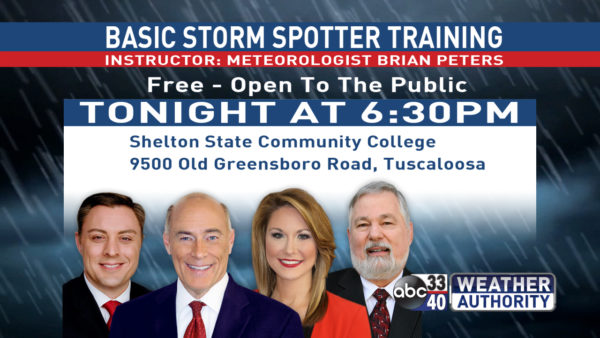
SPOTTER TRAINING IS TONIGHT IN TUSCALOOSA: It begins at 6:30 at Shelton State… we need more trained spotters… please come help us make the warning process better. No need to register, just show up!
WEATHER BRAINS: Don’t forget you can listen to our weekly 90 minute netcast anytime on the web, or on iTunes. This is the show all about weather featuring many familiar voices, including our meteorologists here at ABC 33/40.
CONNECT: You can find me on all of the major social networks…
Facebook
Twitter
Google Plus
Instagram
Pinterest
Snapchat: spannwx
I have a weather program this morning at McAdory Elementary… look for the next Weather Xtreme video here by 4:00 this afternoon. Enjoy the day!
Category: Alabama's Weather, ALL POSTS
About the Author (Author Profile)
James Spann is one of the most recognized and trusted television meteorologists in the industry. He holds the AMS CCM designation and television seals from the AMS and NWA. He is a past winner of the Broadcast Meteorologist of the Year from both professional organizations.Subscribe
If you enjoyed this article, subscribe to receive more just like it.


