Severe Thunderstorm Warning Canceled For Parts Of Cherokee County
…THE SEVERE THUNDERSTORM WARNING FOR SOUTHEASTERN CHEROKEE COUNTY IS CANCELLED… The storm which prompted the warning has moved out of the area. Therefore the warning has been cancelled. A tornado watch remains in effect until 900 PM CDT for northeastern Alabama.
Severe Thunderstorm Warning Continues For Parts Of Cherokee County Until 5:15PM
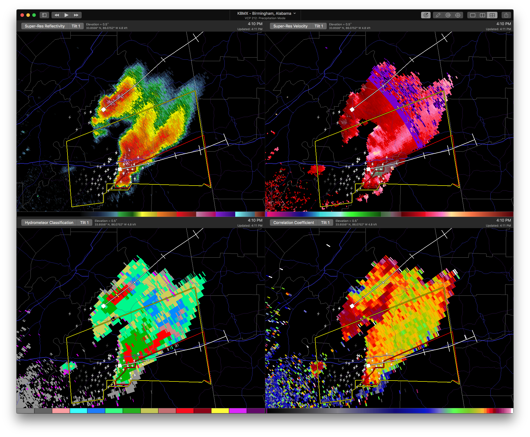
Apr 5th @ 4:10 pm

…A SEVERE THUNDERSTORM WARNING REMAINS IN EFFECT UNTIL 515 PM CDT FOR SOUTHEASTERN CHEROKEE COUNTY… At 428 PM CDT, a severe thunderstorm was located near Ball Flat, or near Piedmont, moving northeast at 45 mph.
HAZARD…60 mph wind gusts and quarter size hail.
SOURCE…Radar indicated.
IMPACT…Hail damage to vehicles is expected. Expect wind damage to roofs, siding, and trees. Locations impacted include… Forney, Tennala, Moshat, Ball Flat, Coloma, Howells Crossroads and Waterhouse.
Severe Thunderstorm Warning Canceled For Parts Of Calhoun And Etowah Counties
Apr 5th @ 4:10 pm
…THE SEVERE THUNDERSTORM WARNING FOR NORTH CENTRAL CALHOUN AND EAST CENTRAL ETOWAH COUNTIES IS CANCELLED… The severe thunderstorm which prompted the warning has moved out of the warned area. Therefore, the warning has been cancelled. A tornado watch remains in effect until 900 PM CDT for northeastern Alabama.
Severe Thunderstorm Warning Continues For Parts Of Calhoun, Cherokee, And Etowah Counties Until 5:15PM
Apr 5th @ 4:10 pm
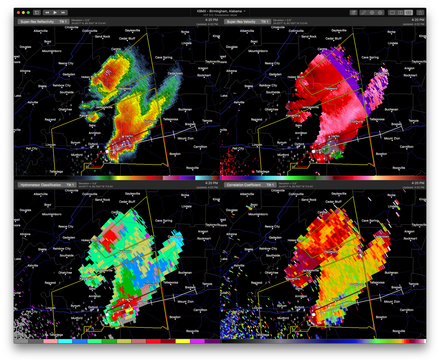

…A SEVERE THUNDERSTORM WARNING REMAINS IN EFFECT UNTIL 515 PM CDT FOR NORTH CENTRAL CALHOUN…EAST CENTRAL ETOWAH AND SOUTHEASTERN CHEROKEE COUNTIES… At 420 PM CDT, a severe thunderstorm was located near Ball Flat, or 7 miles west of Piedmont, moving northeast at 45 mph.
HAZARD…Ping pong ball size hail and 60 mph wind gusts.
SOURCE…Radar indicated.
IMPACT…People and animals outdoors will be injured. Expect hail damage to roofs, siding, windows, and vehicles. Expect wind damage to roofs, siding, and trees. Locations impacted include… Piedmont, Hokes Bluff, Forney, Tennala, Moshat, Ball Flat, Pleasant Gap, Coloma, Knightens Crossroads, Howells Crossroads, Reaves and Waterhouse.
Severe Thunderstorm Warning Issued For Parts Of Calhoun, Cherokee, And Etowah Counties Until 5:15PM
Apr 5th @ 4:10 pm

The National Weather Service in Birmingham has issued a
* Severe Thunderstorm Warning for…
Northeastern Calhoun County in east central Alabama…
Southeastern Etowah County in northeastern Alabama…
Southeastern Cherokee County in northeastern Alabama…
* Until 515 PM CDT
* At 409 PM CDT, a severe thunderstorm was located near Jacksonville
State University, or 7 miles northwest of Jacksonville, moving northeast at 45 mph.
HAZARD…Ping pong ball size hail and 60 mph wind gusts.
SOURCE…Radar indicated.
IMPACT…People and animals outdoors will be injured. Expect hail damage to roofs, siding, windows, and vehicles. Expect wind damage to roofs, siding, and trees.
* Locations impacted include…
Jacksonville, Piedmont, Hokes Bluff, Forney, Glencoe, Tennala, Pleasant Gap, Alexandria, Jacksonville State University, Moshat, Ball Flat, Coloma, Spring Garden, Cobb City, Knightens Crossroads, Sulphur Springs, Howells Crossroads, Reaves, Waterhouse and
Wellington.
Category: ALL POSTS, Archived Warnings
About the Author (Author Profile)
Subscribe
If you enjoyed this article, subscribe to receive more just like it.


