

A Few Illegal Showers

A few light showers are moving southeast across North Alabama tonight in the strong northwesterly upper flow around a big upper low that is pinwheeling over the Northeast U.S.
We call the illegal showers because they technically are not in our forecast for tonight. And that’s what the late, great J.B. Elliott always called unforecast weather.
At 645 p.m., they were over Parts of Marion and Winston Counties. Others were over Marshall and Etowah Counties in Northeast Alabama. Still overs were over southern Tennessee and the Shoals area of Northwest Alabama.
It was a similar situation over northern Mississippi, where other showers extend from Batesville to Tupelo. Those could affect West Central Alabama later.
Any precipitation amounts will be light and the precipitation should wane quickly now that we have lost all the heating of the day. After all, the instability caused by sunshine warming the lower layer of the atmosphere was a primary contributor to their formation. They were aided by disturbances in the fast flow aloft as well.
Still monitoring the possibility of frost or a freeze tomorrow night. Here are GFS numbers for tomorrow night.
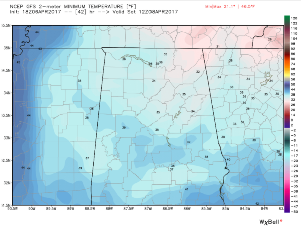
Colder, protected locations could be 3-5 degrees colder. SO protect any tender vegetation.
Category: Alabama's Weather, ALL POSTS
About the Author (Author Profile)
Bill Murray is the President of The Weather Factory. He is the site's official weather historian and a weekend forecaster. He also anchors the site's severe weather coverage. Bill Murray is the proud holder of National Weather Association Digital Seal #0001 @wxhistorianSubscribe
If you enjoyed this article, subscribe to receive more just like it.


