Radar Check at 12:30 pm Shows Increasing Showers and Storms Over North Alabama
Showers and storms are increasing across the Tennessee Valley of North Alabama early this afternoon, in the vicinity of a frontal system that extends from southern Oklahoma across Arkansas to near Memphis and Nashville.
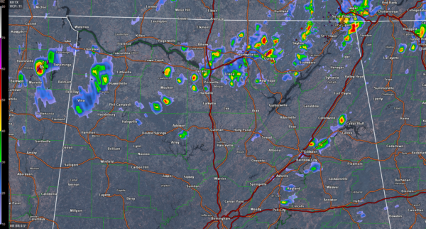
The only cells tall enough to support lightning at this hour are near Bridgeport in Jackson County and in the Huntsville area. Showers around Scottsboro are stating to build toward being storms as well.
They are not severe at this time, and only isolated severe weather is expected with them through the afternoon. The Bridgeport storm may be producing pea sized hail now.
A strong storm is approaching Northwest Alabama’s Lauderdale and Colbert Counties. It could produce hail and gusty winds as it moves near Cherokee and Florence over the next hour.
The main threat this afternoon would be hail and damaging wind gusts, but very heavy rains and frequent lightning will increasingly be a problem in that area.
There is a marginal risk of severe weather across the Tennessee Valley of North Alabama for this afternoon and tonight.
Other showers and forming over St. Clair and Etowah Counties of Northeast Alabama in an area of slightly higher instability. Temperature are a couple of degrees higher over there thanks to less cloud cover.
Category: ALL POSTS
About the Author (Author Profile)
Bill Murray is the President of The Weather Factory. He is the site's official weather historian and a weekend forecaster. He also anchors the site's severe weather coverage. Bill Murray is the proud holder of National Weather Association Digital Seal #0001 @wxhistorianSubscribe
If you enjoyed this article, subscribe to receive more just like it.


