Severe Thunderstorm Warning Expired For Parts Of Dekalb, Jackson, And Franklin (TN) Counties
…THE SEVERE THUNDERSTORM WARNING FOR JACKSON…DEKALB AND FRANKLIN
COUNTIES WILL EXPIRE AT 400 PM CDT…
The storms which prompted the warning have weakened below severe
limits, and no longer pose an immediate threat to life or property.
Therefore the warning will be allowed to expire. However, gusty
winds are still possible with these thunderstorms.
A tornado watch remains in effect until 700 PM CDT for northeastern
Alabama…and Middle Tennessee.
Severe Thunderstorm Warning Continues For Parts Of Dekalb, Jackson, And Franklin (TN) Counties Until 4:00PM
Apr 30th @ 2:54 pm

…A SEVERE THUNDERSTORM WARNING REMAINS IN EFFECT UNTIL 400 PM CDT FOR JACKSON…DEKALB AND FRANKLIN COUNTIES… At 349 PM CDT, severe thunderstorms were located along a line extending from near Estill Springs to near Collinsville, moving east at 40 mph.
HAZARD…60 mph wind gusts.
SOURCE…Radar indicated.
IMPACT…Expect damage to roofs, siding, and trees. Locations impacted include… Scottsboro, Fort Payne, Winchester, Rainsville, Bridgeport, Little River Canyon National Preserve, Decherd, Henagar, Estill Springs and Stevenson.
Severe Thunderstorm Warning Canceled For Parts Of Marshall And Moore (TN) Counties
Apr 30th @ 2:54 pm
…THE SEVERE THUNDERSTORM WARNING FOR NORTHEASTERN MARSHALL AND EASTERN MOORE COUNTIES IS CANCELLED… The storms which prompted the warning have moved out of Moore and Marshall counties. Therefore, the warning has been cancelled. A tornado watch remains in effect until 700 PM CDT for north central and northeastern Alabama…and Middle Tennessee.
Severe Thunderstorm Warning Continues For Parts Of Dekalb, Jackson, Marshall, Franklin (TN), And Moore (TN) Counties Until 4:00PM
Apr 30th @ 2:54 pm

…A SEVERE THUNDERSTORM WARNING REMAINS IN EFFECT UNTIL 400 PM CDT FOR JACKSON…NORTHEASTERN MARSHALL…DEKALB…EASTERN MOORE AND FRANKLIN COUNTIES… At 333 PM CDT, severe thunderstorms were located along a line extending from 7 miles north of Tullahoma to near Crossville, moving northeast at 55 mph.
HAZARD…60 mph wind gusts.
SOURCE…Radar indicated.
IMPACT…Expect damage to roofs, siding, and trees. Locations impacted include… Scottsboro, Fort Payne, Boaz, Winchester, Rainsville, Bridgeport, Little River Canyon National Preserve, Decherd, Henagar and Estill Springs.
Severe Thunderstorm Warning Canceled For Parts Of Madison And Lincoln (TN) Counties
Apr 30th @ 2:54 pm
…THE SEVERE THUNDERSTORM WARNING FOR EASTERN MADISON AND EASTERN LINCOLN COUNTIES IS CANCELLED… The storms which prompted the warning have moved out of the warned area. Therefore, the warning has been cancelled. A tornado watch remains in effect until 700 PM CDT for north central and northeastern Alabama…and Middle Tennessee.
Severe Thunderstorm Warning Continues For Parts Of Dekalb, Jackson, Madison, Marshall, Franklin (TN), Lincoln (TN), And Moore (TN) Counties Until 4:00PM
Apr 30th @ 2:54 pm

…A SEVERE THUNDERSTORM WARNING REMAINS IN EFFECT UNTIL 400 PM CDT FOR JACKSON…MARSHALL…EASTERN MADISON…DEKALB…MOORE…EASTERN LINCOLN AND FRANKLIN COUNTIES… At 317 PM CDT, severe thunderstorms were located along a line extending from Lynchburg to Albertville, moving northeast at 40 mph.
HAZARD…60 mph wind gusts.
SOURCE…Radar indicated.
IMPACT…Expect damage to roofs, siding, and trees. Locations impacted include… Albertville, Scottsboro, Fort Payne, Boaz, Winchester, Guntersville, Fayetteville, Rainsville, Bridgeport and Lynchburg.
Severe Thunderstorm Warning Issued For Parts Of Dekalb, Jackson, Madison, Marshall, Franklin (TN), Lincoln (TN), And Moore (TN) Counties Until 4:00PM
Apr 30th @ 2:54 pm
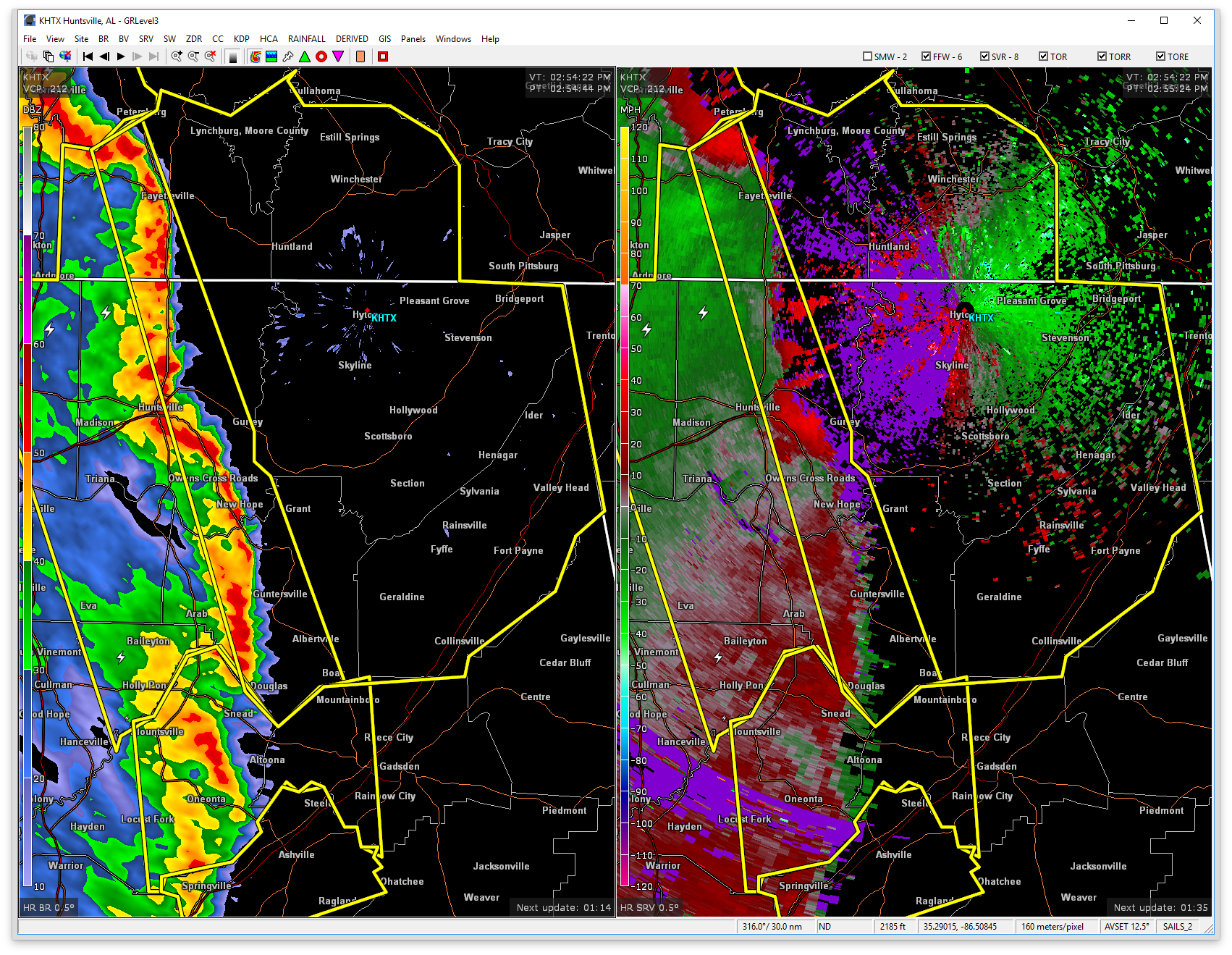

The National Weather Service in Huntsville Alabama has issued a
* Severe Thunderstorm Warning for…
Jackson County in northeastern Alabama…
Marshall County in northeastern Alabama…
Central Madison County in north central Alabama…
DeKalb County in northeastern Alabama…
Moore County in Middle Tennessee…
Lincoln County in Middle Tennessee…
Franklin County in Middle Tennessee…
* Until 400 PM CDT
* At 252 PM CDT, severe thunderstorms were located along a line extending from near Petersburg to near Altoona, moving northeast at 55 mph.
HAZARD…60 mph wind gusts.
SOURCE…Radar indicated.
IMPACT…Expect damage to roofs, siding, and trees.
* Locations impacted include…
Huntsville, Albertville, Scottsboro, Fort Payne, Boaz, Winchester, Guntersville, Fayetteville, Rainsville and Bridgeport.
Category: ALL POSTS, Archived Warnings
About the Author (Author Profile)
Subscribe
If you enjoyed this article, subscribe to receive more just like it.


