Late Evening Look at the Alabama Weather Situation
Can you find the cold front in this image?
Can you find the cold front in this image?
An area of showers and storms is pushing across eastern Mississippi and western Alabama at this hour.
A severe thunderstorm warning was just issued for Choctaw County Alabama and Wayne County in Mississippi, to go along with a severe thunderstorm warning issued a short time ago by Jackson for Clarke County MS. These storms will move toward Marengo County and if they hold together, toward Perry, Dallas, Chilton and Autauga.
The NWS Jackson also issued a flash flood warning for Clark County, to go along with flash flood warnings for Jones and Forest Counties in Mississippi.
Moderate to occasionally heavy rain cover parts of Sumter, Greene, Hale, Tuscaloosa, Walker, Fayette, Lamar, Marion and Winston Counties now. Embedded thunder exists from Hale and Pickens Counties southwestward back into Mississippi along I-59.
In Central Alabama, a strong storm was over Fayette County. Lots of lightning with that one as well as heavy rain.
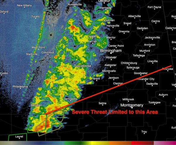
The best chance for any severe weather will be with the stronger storms that will move across Southwest and South Central Alabama. For areas north of a line from Demopolis to Clanton to Roanoke, it will just be a wet night with some loud thunder in the I-59 Corridor.
South of that line, some severe weather is possible, mainly in the form of damaging wind gusts. There should be no tornado threat.
The cold front is that very thin line of echoes on the Columbus radar over eastern Mississippi.
Category: Alabama's Weather, ALL POSTS
About the Author (Author Profile)
Bill Murray is the President of The Weather Factory. He is the site's official weather historian and a weekend forecaster. He also anchors the site's severe weather coverage. Bill Murray is the proud holder of National Weather Association Digital Seal #0001 @wxhistorianSubscribe
If you enjoyed this article, subscribe to receive more just like it.


