

Clouds Moving Into Central Alabama At Midday Ahead Of Our Next System
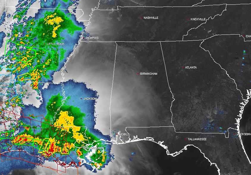
As you can see by our combination visible satellite and composite radar image of the southeastern United States, high clouds from the tops of the storms back in Mississippi, Arkansas, and Louisiana, have moved in over much of Central Alabama, while a few locations in the eastern part of the area still are enjoying bright sunshine. We have no shower or storm activity in Central Alabama at this moment, but that will change as we get into the evening hours.
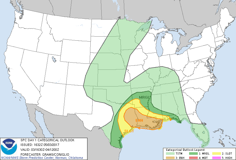
Back to our west, we do have an enhanced risk for severe storms today stretching from the eastern part of Texas into the southern 2/3rds of Louisiana and clipping the extreme southern parts of Mississippi. A slight risk surrounds that area, and actually includes Mobile and Baldwin counties in Alabama. At this moment, a Tornado Watch is in effect until 5:00PM CDT for southern and western Louisiana, along with southeast Texas. A Severe Thunderstorm Watch is in effect for southwest Arkansas, northwest Louisiana, and north-central to northeast Texas until 7:00PM CDT tonight.
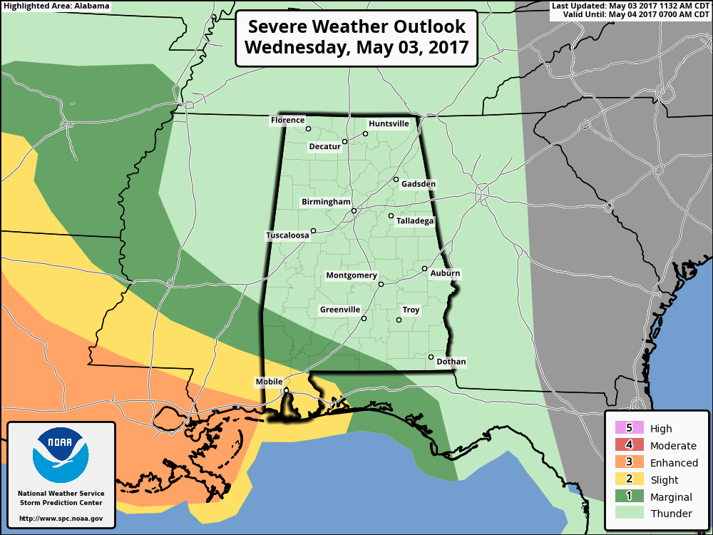
The good news for Central Alabama is the latest update from the Storm Prediction Center is in, and they have removed all locations in our area from the marginal risk for severe storms and just have us in general thunderstorms for tonight until 7:00AM Thursday morning.
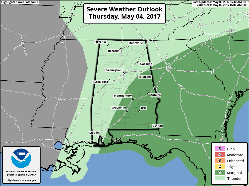
SPC continues to have the southeastern parts of Central Alabama in a marginal risk for severe storms throughout the day on Thursday, including the locations of Montgomery, Auburn, Troy, Eufaula, and Alexander City.
Before the rain moves in, skies will become cloudy where they are not cloudy yet, and afternoon highs will be in the mid to upper 80s. The large mass of rain is projected by the HRRR to move into the western parts of the state around or just before the 4:00PM hour this afternoon, and reaching the Birmingham metropolitan area by 7:00PM to 8:00PM this evening. Rain will have moved over into Georgia and out of much of the northern parts of Central Alabama by 8:00AM on Thursday morning. The main action will be along the Gulf Coast during the evening through the morning hours on Thursday, and this will limit the energy from progressing to the north, and will keep the severe storm chances out of Central Alabama.
We will have a break from the rain for a decent part of the morning, before more showers and storms develop by midday along and ahead of a surface cold front that will be moving through the area. Surface based instability still looks rather low at this point, so the severe weather risk will be very low. We’re only expecting about 1/2 to 1 inch of rainfall, so the risk of flash flooding will be low as well. When it’s not raining, we’ll have cloudy skies, and highs will be in the mid 60s to the mid 70s.
BEACH FORECAST
From the shores of Fort Morgan to the sands of Panama City Beach, click here to see what the forecast holds on our Beach Forecast Center page. Save Up To 25% on Spring Break Beach Vacations on the Alabama Gulf Coast with Brett/Robinson! The Beach Forecast is partially underwritten by the support of Brett/Robinson Vacation Rentals in Gulf Shores and Orange Beach. Click here to see Brett/Robinson’s best beach offers now!
ON THIS DAY IN WEATHER HISTORY – May 3, 1999
An unusual confluence of atmospheric conditions in Oklahoma spawned dozens of tornadoes that swept across the state in an hours-long parade of destruction. Thousands of homes were damaged or destroyed, and 19 counties became disaster areas. The worst toll was in human lives: 44 dead, including three children. Hundreds more were injured.
WEATHERBRAINS
Don’t forget you can listen to the weekly 90 minute netcast anytime on the web, or on iTunes. This is the show all about weather featuring many familiar voices, including meteorologists at ABC 33/40. Shows are usually produced on Monday evenings starting at 8:30 CDT… you can watch it live here.
ADVERTISE WITH US
Deliver your message to a highly engaged audience by advertising on the AlabamaWX.com website. Over 4 million pages views just since April 1st! Don’t miss out! We can customize a creative, flexible and affordable package that will suit your organization’s needs. We would love to work with you. Contact Bill Murray at (205) 687-0782 for more information.
Category: Alabama's Weather, ALL POSTS
About the Author (Author Profile)
Scott Martin is an operational meteorologist, professional graphic artist, musician, husband, and father. Not only is Scott a member of the National Weather Association, but he is also the Central Alabama Chapter of the NWA president. Scott is also the co-founder of Racecast Weather, which provides forecasts for many racing series across the USA. He also supplies forecasts for the BassMaster Elite Series events including the BassMaster Classic.Subscribe
If you enjoyed this article, subscribe to receive more just like it.


