Wind Advisory Extended Until 9 p.m. Tonight

The NWS in Birmingham has extended the Wind Advisory until 9 p.m. CDT tonight for all of Central Alabama.
From Jody Aaron at the NWS: Winds have settled down in the east, behind the initial wave of rain. However, the cold front will now move across the area through tonight. Behind the front winds will once again begin to increase. While not as widespread as the morning, winds will still be 15 to 25 mph with higher gusts. Winds as far back as the Mississippi River are currently at 20 to 25 mph or higher from the west to west-northwest. These wind will move into the western counties by 2 pm and exit the east around 9 pm.
The National Weather Service in Birmingham has issued a Wind Advisory, which is in effect through tonight to 7PM CDT Thursday.
* TIMING…Through 7 PM Thursday.
* WINDS…Sustained at 15-25 mph with gusts to 35-40 mph.
* IMPACTS…Strong winds could result in large limbs and weak trees being blown down.
A Wind Advisory means that winds of 35 mph are expected. Winds this strong can make driving difficult, especially for high profile vehicles. Use extra caution.
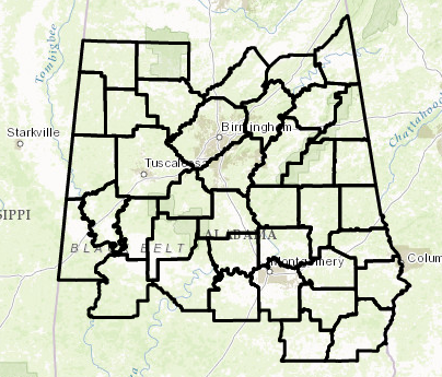
Counties in Central Alabama included in the Wind Advisory:
Marion, Lamar, Fayette, Winston, Walker, Blount, Etowah, Calhoun, Cherokee, Cleburne, Pickens, Tuscaloosa, Jefferson, Shelby, St. Clair, Talladega, Clay, Randolph, Sumter, Greene, Hale, Perry, Bibb, Chilton, Coosa, Tallapoosa, Chambers, Marengo, Dallas, Autauga, Lowndes, Elmore, Montgomery, Macon, Bullock, Lee, Russell, Pike, & Barbour.
Locations in Central Alabama included in the Wind Advisory:
Hamilton, Sulligent, Vernon, Fayette, Double Springs, Jasper, Oneonta, Gadsden, Anniston, Centre,
Heflin, Carrollton, Tuscaloosa, Birmingham, Hoover, Columbiana, Pelham, Alabaster, Pell City, Moody, Talladega, Sylacauga, Ashland, Roanoke, Livingston, Eutaw, Greensboro, Moundville, Marion, Centreville, Clanton, Rockford, Alexander City, Dadeville, Valley, Lanett, Lafayette, Demopolis, Linden, Selma,
Prattville, Fort Deposit, Hayneville, Wetumpka, Tallassee, Montgomery, Tuskegee, Union Springs, Auburn, Opelika, Phenix City, Troy, & Eufaula.
Category: Alabama's Weather, ALL POSTS
About the Author (Author Profile)
Scott Martin is an operational meteorologist, professional graphic artist, musician, husband, and father. Not only is Scott a member of the National Weather Association, but he is also the Central Alabama Chapter of the NWA president. Scott is also the co-founder of Racecast Weather, which provides forecasts for many racing series across the USA. He also supplies forecasts for the BassMaster Elite Series events including the BassMaster Classic.Subscribe
If you enjoyed this article, subscribe to receive more just like it.


