A Quick Look At Central Alabama’s Weather At Rush Hour
RADAR CHECK
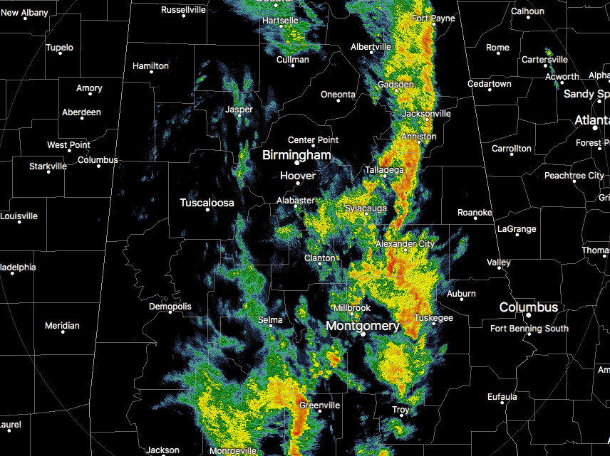
As you can see by the radar image, much of the rain activity has moved east of the I-65 corridor at this time, but we still have a few scattered light showers back to the west of that. The cold front is currently stretching from north to south across across the eastern part of the state, roughly from Albertville to Sylacauga to Montgomery to Evergreen.
Once the cold front moves through, then the upper low will move into the area, and winds will begin to increase due to the pressure gradient. NWS Birmingham has extended the Wind Advisory for all of Central Alabama until 9PM tonight. For the rest of the evening, rain chances will be best for the locations east of I-65, even though a few scattered showers could be possible west of that. Overnight lows will be in the mid to upper 40s with cloudy skies.
Tomorrow can be called an almost winter-like day across Central Alabama. Skies will be cloudy throughout the day on Friday, and we’ll have periods of light rain due to wrap-around moisture from the low. Winds will be quite breezy, out of the west at 15-25 MPH, making the afternoon highs feel colder. Highs are expected to be in the mid 50s to the upper 60s throughout the area. If Birmingham fails to reach 60 degrees tomorrow, it will establish a record low maximum temperature for May 5th. The current record is 60 degrees set back in 1917.
Category: Alabama's Weather, ALL POSTS
About the Author (Author Profile)
Scott Martin is an operational meteorologist, professional graphic artist, musician, husband, and father. Not only is Scott a member of the National Weather Association, but he is also the Central Alabama Chapter of the NWA president. Scott is also the co-founder of Racecast Weather, which provides forecasts for many racing series across the USA. He also supplies forecasts for the BassMaster Elite Series events including the BassMaster Classic.Subscribe
If you enjoyed this article, subscribe to receive more just like it.


