

It’s A Warming On Up At Midday Across Central Alabama

At the midday hour across Central Alabama, skies are generally clear, but there are a few thin clouds that are real high up in the sky. Those are very hard to see on the visible satellite image. One thing that is not hard to see is how wonderful the weather is across the southeastern U.S. A few showers and storms are occurring north of the region portions of Kentucky, the Virginias, and down into North Carolina, but those will pose no threat to our weather as they are pushing off to the southeast.
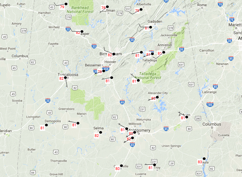
Temperatures across Central Alabama at 11:50AM are running in the upper 70s to the lower 80s. Eufaula is currently the warm spot at 83 degrees, while Cullman is the cool spot at 78 degrees.
AIR QUALITY CHECK
The air quality for the Birmingham Metropolitan area will be in a CODE YELLOW (MODERATE) level today due to increased levels of Ozone and Particulate Matter (PM2.5). Unusually sensitive people should consider limiting prolonged outdoor exertion throughout the day.
REMAINDER OF TUESDAY’S WEATHER
Skies will remain sunny throughout the rest of the afternoon, with a few high and thin clouds floating across the sky. Temperatures will be quite warm, as the mercury is expected to reach the mid to upper 80s throughout the area. I wouldn’t be surprised if a location or two in the extreme southern parts of Central Alabama touch 90 degrees today. Great weather for this evening as the clear skies will continue throughout the evening and overnight hours. Temperatures at the 7PM hour will be in the upper 70s to the lower 80s, and overnight lows will drop down into the upper 50s to the lower 60s.
WEDNESDAY’S WEATHER IS FEELING HOT, HOT, HOT!
Tomorrow will be another day with mostly sunny skies and very warm temperatures. Afternoon highs will be in the upper 80s to the lower 90s… and in my book, when you hit 90 degrees, that is hot. The high is expected to be 89 tomorrow in Birmingham, but I wouldn’t be surprised if the Magic City hits 90 degrees. Dewpoints will be in the near or just over 60 degrees tomorrow, so it will feel quite warm, but not the sweltering feeling that we get in July and August. Skies will be mostly clear for Wednesday evening, but will be on the increase during the overnight hours. Temperatures at 7PM will be in the lower to mid 80s across the area, and only dropping into the lower to mid 60s for the overnight lows.
BEACHBOUND
If you would like to see what the weather holds for Ft. Morgan over to Panama City Beach, click here to see the Beach Forecast Center page. Save Up To 25% on Spring Break Beach Vacations on the Alabama Gulf Coast with Brett/Robinson! The Beach Forecast is partially underwritten by the support of Brett/Robinson Vacation Rentals in Gulf Shores and Orange Beach. Click here to see Brett/Robinson’s best beach offers now!
THIS DAY IN WEATHER HISTORY – May 9, 1990
Thunderstorms produced severe weather in the central U.S. during the evening hours, mainly from southeastern Missouri to southwestern Indiana. Severe thunderstorms spawned four tornadoes, including two strong (F-2) tornadoes in southern Illinois. Strong thunderstorm winds gusted to 85 mph at Orient IL, and to 100 mph at West Salem. Thunderstorms drenched northeastern Illinois with up to 4.50 inches of rain.
Category: Alabama's Weather, ALL POSTS
About the Author (Author Profile)
Scott Martin is an operational meteorologist, professional graphic artist, musician, husband, and father. Not only is Scott a member of the National Weather Association, but he is also the Central Alabama Chapter of the NWA president. Scott is also the co-founder of Racecast Weather, which provides forecasts for many racing series across the USA. He also supplies forecasts for the BassMaster Elite Series events including the BassMaster Classic.Subscribe
If you enjoyed this article, subscribe to receive more just like it.


