

Severe Thunderstorm Warning Expired For Parts Of Jefferson County
…THE SEVERE THUNDERSTORM WARNING FOR NORTHEASTERN JEFFERSON COUNTY
WILL EXPIRE AT 345 AM CDT…
The storms which prompted the warning have weakened below severe
limits, and no longer pose an immediate threat to life or property.
Therefore the warning will be allowed to expire.
Severe Thunderstorm Warning Continues For Parts Of Jefferson County Until 3:45AM
May 28th @ 2:29 am

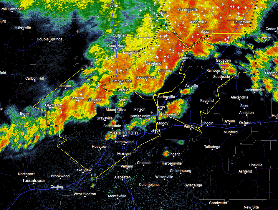
…A SEVERE THUNDERSTORM WARNING REMAINS IN EFFECT UNTIL 345 AM CDT FOR NORTHEASTERN JEFFERSON COUNTY… At 331 AM CDT, severe thunderstorms were located along a line extending from near Tannehill Ironworks State Park to Bald Rock, moving southeast at 40 mph.
HAZARD…60 mph wind gusts.
SOURCE…Radar indicated.
IMPACT…Expect damage to roofs, siding, and trees. Locations impacted include… Birmingham, Vestavia Hills, Homewood, Mountain Brook, Trussville, Gardendale, Irondale, Leeds, Moody, Fultondale, Pinson-Clay-chalkv, Center Point, Clay, Pinson, Tarrant, Ketona Lakes, B.j.c.c., Chalkville, Kingston and Grayson Valley.
Severe Thunderstorm Warning Continues For Parts Of Jefferson County Until 3:45AM
May 28th @ 2:29 am

…A SEVERE THUNDERSTORM WARNING REMAINS IN EFFECT UNTIL 345 AM CDT FOR JEFFERSON COUNTY… At 311 AM CDT, severe thunderstorms were located along a line extending from Bull City to near Clay, moving southeast at 35 mph.
HAZARD…60 mph wind gusts.
SOURCE…Radar indicated.
IMPACT…Expect damage to roofs, siding, and trees. Locations impacted include… Birmingham, Hoover, Vestavia Hills, Bessemer, Homewood, Mountain Brook, Trussville, Hueytown, Gardendale, Irondale, Leeds, Moody, Fairfield, Fultondale, Sumiton, Pinson-Clay-chalkv, Center Point, Pleasant Grove, Clay and Pinson.
Severe Thunderstorm Warning Canceled For Parts Of Walker County
May 28th @ 2:29 am
…THE SEVERE THUNDERSTORM WARNING FOR SOUTHEASTERN WALKER COUNTY IS CANCELLED… The storms which prompted the warning have moved out of the warned area. Therefore, the warning has been cancelled.
Severe Thunderstorm Warning Continues For Parts Of Jefferson And Walker Counties Until 3:45AM
May 28th @ 2:29 am

…A SEVERE THUNDERSTORM WARNING REMAINS IN EFFECT UNTIL 345 AM CDT FOR SOUTHEASTERN WALKER AND JEFFERSON COUNTIES… At 253 AM CDT, severe thunderstorms were located along a line extending from 6 miles northwest of Oak Grove to near Morris, moving southeast at 40 mph.
HAZARD…60 mph wind gusts.
SOURCE…Radar indicated.
IMPACT…Expect damage to roofs, siding, and trees. Locations impacted include… Birmingham, Hoover, Vestavia Hills, Bessemer, Homewood, Mountain Brook, Trussville, Hueytown, Gardendale, Irondale, Leeds, Moody, Fairfield, Fultondale, Sumiton, Cordova, Dora, Pinson-Clay-chalkv, Center Point and Pleasant Grove.
Severe Thunderstorm Warning Issued For Parts Of Jefferson And Walker Counties Until 3:45AM
May 28th @ 2:29 am

The National Weather Service in Birmingham has issued a
* Severe Thunderstorm Warning for…
Walker County in Alabama…
Jefferson County in Alabama…
* Until 345 AM CDT
* At 228 AM CDT, severe thunderstorms were located along a line extending from near Oakman to near Smith Dam, moving southeast at 40 mph.
HAZARD…60 mph wind gusts.
SOURCE…Radar indicated.
IMPACT…Expect damage to roofs, siding, and trees.
* Locations impacted include…
Birmingham, Hoover, Vestavia Hills, Bessemer, Homewood, Mountain
Brook, Trussville, Hueytown, Jasper, Gardendale, Irondale, Leeds, Moody, Fairfield, Fultondale, Sumiton, Cordova, Dora, Pinson-Clay-chalkville and Center Point.
Category: ALL POSTS, Archived Warnings
About the Author (Author Profile)
Subscribe
If you enjoyed this article, subscribe to receive more just like it.


