New Look To The Tools Used By The NHC For The 2017 Hurricane Season
A New Look To The National Hurricane Center Graphics

Click image to enlarge.
The National Hurricane Center is changing the appearance of the graphics accompanying tropical cyclone advisory packages for the 2017 Hurricane season. The following graphical products will have a new look:
• 5-Day Tropical Cyclone Track Forecast Cone, Initial Wind Field, and watches/Warnings
• 3-Day Tropical Cyclone Track Forecast Cone, Initial Wind Field, and watches/Warnings
• Tropical Cyclone Surface Wind Field
• Tropical Cyclone Cumulative Wind History
• Tropical Cyclone Surface Wind Speed Probabilities
NEW Tropical Storm Force Winds Arrival Time Graphics
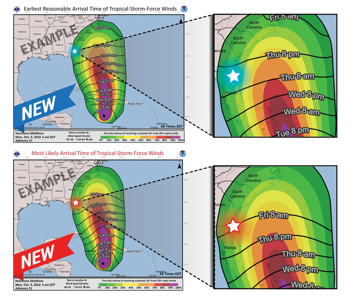
Click image to enlarge.
Earliest Reasonable Arrival Time of Tropical Storm Force Winds (39 MPH or greater) Graphic (top)
Most appropriate for people who have a low tolerance for risk and absolutely need to have all their preparations done before the storm arrives.
Sustained tropical storm force winds have less than a 1-in-10 or 10% chance of occurring before the times indicated in this graphic.
Most Likely Arrival Time of Tropical Storm Force Winds (39 MPH or greater) Graphic (bottom)
Most appropriate for people who have a higher tolerance for risk and who will base their preparation on the most likely arrival time.
The onset of sustained tropical storm force winds are most likely near the times in this graphic.
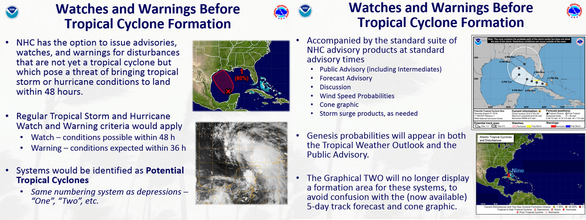
Watches and Warnings Before Tropical Cyclone Formation
Click image to enlarge.
NHC has the option to issue advisories, watches, and warnings for disturbances that are not yet a tropical cyclone but which pose a threat of bringing tropical storm or hurricane conditions to land within 48 hours.
Regular Tropical Storm and Hurricane Watch and Warning criteria would apply.
• Watch – conditions possible within 48 hours
• Warning – conditions expected within 36 hours
Systems would be identified as Potential Tropical Cyclones.
• Same numbering system as depressions (one, two, etc.)
Accompanied by the standard suite of NHC advisory products at standard advisory times.
• Public Advisory (including intermediated)
• Forecast Advisory
• Discussion
• Wind Speed Probabilities
• Cone Graphic
• Storm Surge Products (as needed)
Genesis probabilities will appear in both the Tropical Weather Outlook and the Public Advisory.
The Graphical Tropical Weather Outlook will no longer display a formation area for these systems, to avoid confusion with the 5-day track forecast and cone graphic.
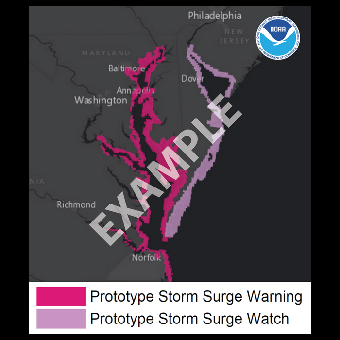
NEW Storm Surge Watch & Warning Graphics
Click image to enlarge.
Storm Surge Watch
The possibility of life-threatening flooding from rising water moving inland from the shoreline in the next 48 hours. This is a potentially life-threatening situation. Persons located within the watch areas should be ready to take all necessary actions to protect life and property from rising water and the potential for other dangerous conditions. Promptly follow evacuation and other instructions from local officials.
Storm Surge Warning
There is a danger of life-threatening inundation from rising water moving inland from the shoreline generally within 36 hours. This is a dangerous, life-threatening situation. Persons located within the warning areas should take all necessary actions to protect life and property from rising water and the potential for other dangerous conditions. Promptly follow evacuation and other instructions from local officials.
All information and graphics from the National Hurricane Center.
About the Author (Author Profile)
Scott Martin is an operational meteorologist, professional graphic artist, musician, husband, and father. Not only is Scott a member of the National Weather Association, but he is also the Central Alabama Chapter of the NWA president. Scott is also the co-founder of Racecast Weather, which provides forecasts for many racing series across the USA. He also supplies forecasts for the BassMaster Elite Series events including the BassMaster Classic.Subscribe
If you enjoyed this article, subscribe to receive more just like it.


