

It’s The First Day Of Meteorological Summer & It Looks That Way Across Central Alabama
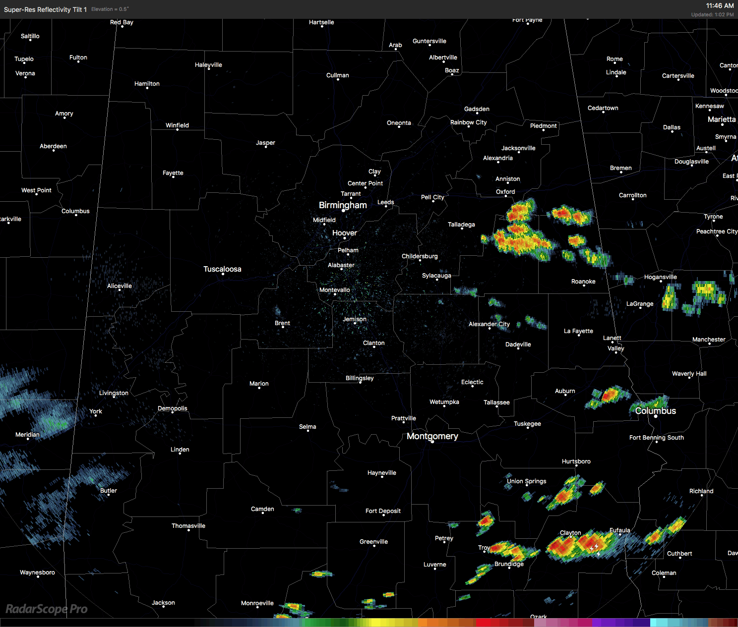
Showers and thunderstorms have fired up across the east and southeastern parts of Central Alabama as we approach the 1 o’clock hour. There is a decent thunderstorm currently affecting Talladega, Cleburne, Clay, and Randolph counties at the moment, producing heavy rainfall and dangerous lightning. These storms is expanding northward as it is slowly pushing to the east.
Another hot spot for shower and thunderstorm activity is down in the southeastern parts of the area, affecting Pike, Bullock, Barbour, Russell, and Lee Counties. Heavy rainfall and dangerous lightning are occurring with these storms. These are moving to the northeast.
Other than that, we have a few small showers that have popped up in Central Alabama, and that will probably be the trend for the rest of the afternoon hours and into the early evening.
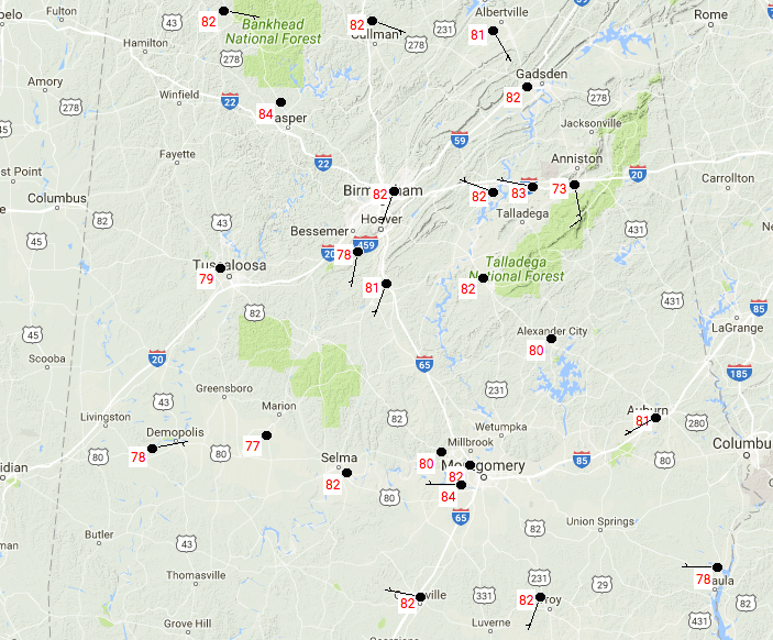
TEMPERATURES THROUGHOUT CENTRAL ALABAMA AT 12:50AM
It’s a warm and muggy day out there already, with current temperatures ranging from the upper 70s up north to the mid 80s throughout the area. Montgomery is the warm spot at 84 degrees, with Marion as the cool spot at 77 degrees.
FOR THE REST OF TODAY
Skies for the afternoon through the early evening hours will mainly mostly cloudy across the area, but we will have a few breaks to allow the sun through at times. We’ll have a risk for scattered showers and thunderstorms, with the better chances the farther south in the area you are. Afternoon highs will be in the lower to mid 80s throughout the area. For the evening and through the overnight hours, skies will remain mostly cloudy throughout the area, with a small risk of lingering showers and thunderstorms. Overnight lows will be in the mid to upper 60s.
FRIDAY’S WEATHER
This warm and muggy pattern continues across Central Alabama for tomorrow, with a risk of showers and thunderstorms mainly during the afternoon. Chances of rain will be greater the farther south you are in Central Alabama. Afternoon highs will be in the lower to mid 80s, with overnight lows in the 60s.
A LOOK AT THE TROPICS
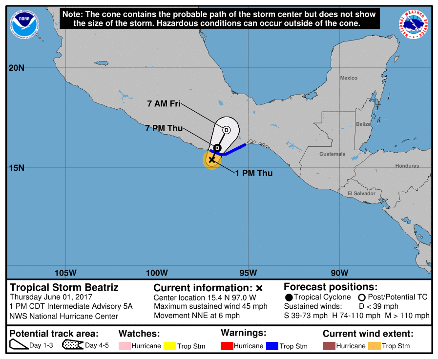
Today is the first day of the Atlantic/Gulf of Mexico hurricane season, and everything is quiet and no tropical storms are expected through the weekend. As far as the Pacific, a tropical depression has now strengthened into Tropical Storm Beatriz, with 45 maximum sustained winds. Beatriz is expected to move over Mexico and lose its tropical characteristics after Friday morning.
BEACHBOUND
For a detailed look at the weather from Fort Morgan over to Panama City Beach, Click here to see the AlabamaWx Beach Forecast Center page. The Beach Forecast is partially underwritten by the support of Brett/Robinson Vacation Rentals in Gulf Shores and Orange Beach. Click here to see Brett/Robinson’s Own Your Summer specials now!
WEATHERBRAINS
Don’t forget you can listen to our weekly 90 minute netcast anytime on the web, or on iTunes. This is the show all about weather featuring many familiar voices, including our meteorologists here at ABC 33/40. We will produce this week’s episode tonight at 8:30… you can watch it live here.
Category: Alabama's Weather, ALL POSTS
About the Author (Author Profile)
Scott Martin is an operational meteorologist, professional graphic artist, musician, husband, and father. Not only is Scott a member of the National Weather Association, but he is also the Central Alabama Chapter of the NWA president. Scott is also the co-founder of Racecast Weather, which provides forecasts for many racing series across the USA. He also supplies forecasts for the BassMaster Elite Series events including the BassMaster Classic.Subscribe
If you enjoyed this article, subscribe to receive more just like it.


