

Warm And Muggy Across Central Alabama At Midday
UPDATE AT MIDDAY
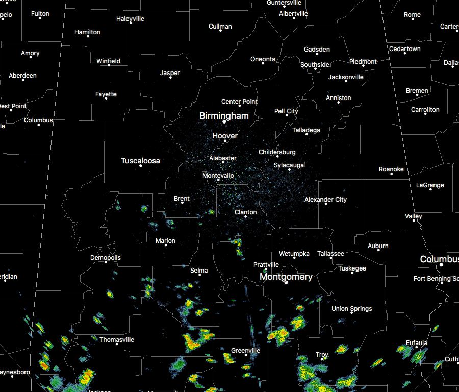
We currently have scattered showers across the southern parts of Central Alabama, mainly below a line from Aliceville to Montevallo to Roanoke. For the rest of the area north of that, we have a mix of sun and clouds out there and temperatures are already up into the 80s at this point.
TEMPERATURES AT MIDDAY
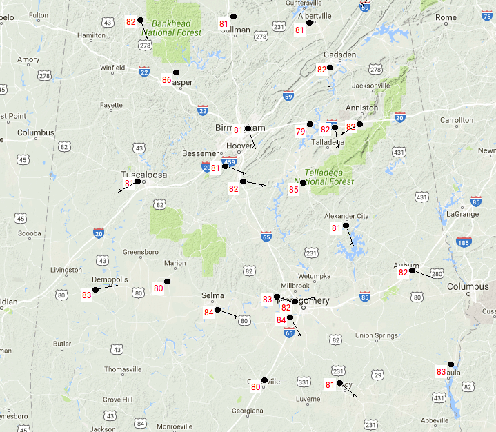
At 11:54 AM, temperatures are in the lower to mid 80s across much of Central Alabama. Montgomery and Selma are tied at this point as the warmest locations at 84 degrees, while the cool spot is at the St. Clair County Airport at 79 degrees.
FOR THE REST OF THE DAY
Skies will be mostly cloudy throughout the rest of the daytime hours with widely scattered showers and thunderstorms, with the better chances in the southern half of the area. Afternoon highs will be in the mid 80s to the lower 90s throughout Central Alabama. Rain chances will decrease throughout the evening, even though there will be a very small risk of a shower or two throughout the area. Otherwise, skies will be partly to mostly cloudy with lows in the upper 60s to the lower 70s.
WEDNESDAY’S WEATHER
Nearly the same forecast for tomorrow as it is for today… A mix of sun and clouds with a risk of scattered showers and thunderstorms, with the better chances to the south. Afternoon highs will be just a tad cooler, but still very warm and muggy, in the mid to upper 80s across Central Alabama.
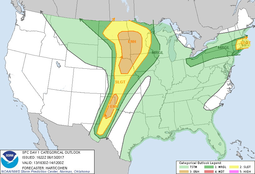
ANY SEVERE WEATHER POSSIBLE TODAY IN THE UNITED STATES?
The answer to that question is… yes. Severe thunderstorms, capable of large hail, damaging winds, and a few tornadoes, will be possible across the northern Plains and upper Mississippi Valley this afternoon and evening. Farther south across the central/southern Plains, scattered severe storms, primarily capable of large hail and damaging winds, are expected through the evening hours. Isolated severe storms will also be possible across southern New England.
HEADING TO THE BEACH
For a detailed look at the weather from Fort Morgan over to Panama City Beach, click here to see the AlabamaWx Beach Forecast Center page. The Beach Forecast is partially underwritten by the support of Brett/Robinson Vacation Rentals in Gulf Shores and Orange Beach. Click here to see Brett/Robinson’s Own Your Summer specials now!
TROPICAL UPDATE
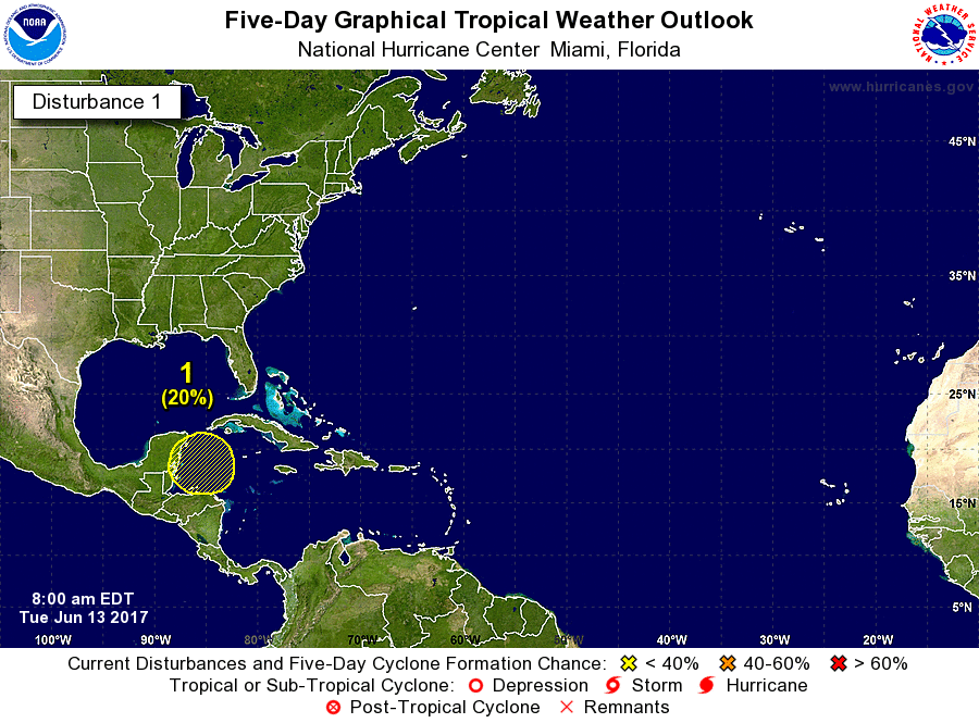
There are several waves that are out there in the open waters of the Atlantic and down in the Gulf of Mexico and Caribbean Sea, but these are not expected to strengthen into an organized system. There is a broad area of low pressure that is expected to form over the western Caribbean Sea or Central America towards the end of this week or this weekend. There could be some gradual development next week as it starts to move slowly to the northwest. As of now, confidence is low for this to develop into an organized system within the next 5 days.
TODAY IN WEATHER HISTORY
June 13, 1989 – Thunderstorms produced severe weather from the Southern Plains Region to the Carolinas during the day and night, and continued to drench parts of Texas and Oklahoma with heavy rain. Oklahoma City reported 13.41 inches of rain for the first thirteen days of the month, and Fort Worth TX reported 29.56 inches for the year, a total more than 13 inches above normal. Severe drought continued to rage across South Texas.
WEATHERBRAINS
It was a great show this week with Lans Rothfusz from the National Severe Storms Laboratory talking about progress on the new severe weather warning paradigm called FACETS. Lans also updated us on Warn on Forecast. Check out the show at www.WeatherBrains.com. You can also subscribe on iTunes.
Category: Alabama's Weather, ALL POSTS
About the Author (Author Profile)
Scott Martin is an operational meteorologist, professional graphic artist, musician, husband, and father. Not only is Scott a member of the National Weather Association, but he is also the Central Alabama Chapter of the NWA president. Scott is also the co-founder of Racecast Weather, which provides forecasts for many racing series across the USA. He also supplies forecasts for the BassMaster Elite Series events including the BassMaster Classic.Subscribe
If you enjoyed this article, subscribe to receive more just like it.


