An In-Depth Look At Invest 93L
A Collaborative Post by Bill Murray and Scott Martin
Invest 93L is the name currently assigned to the disturbance in the southern Gulf of Mexico. It has not risen to the level of Potential Tropical Cyclone yet as the disturbance approaching the southern Windward Islands has (PTC2). That was done yesterday as the NHC invoked a new policy that lets them issue warnings on systems that have not yet been classified as tropical cyclones but are threatening to bring strong winds to coastal locations.
Invest 93 has an exposed low pressure center this morning north of the Yucatan Peninsula with the thunderstorms located on the eastern and southeastern side of the storm. The is because of strong southwesterly wind shear that is keeping the storms from building near the center. This is important for the storm to develop. If the storms can’t built around the center, it won’t become a significant system.
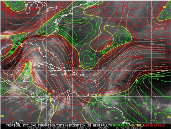
That shear is being caused by an upper level low and trough over the northwestern Gulf of Mexico. The low and mid-level flow is being dominated by the inverted trough and surface low over the southern Gulf. But when you get to the upper levels, there is 30-40 knots of flow from the southwest that is pushing the storms away from the center.
The shear is not forecast to relax as the storm moves northwest, steered by a southeasterly flow in the mid-levels over the southern Gulf.
The presence of the surface low is unmistakable in the wind field. In fact, if it could get its act together structure wise, it is probably already close to being a tropical storm. The intensity guidance suggests it will not get above 40-45 knots over its track over its path if it forms. The Rapid Intensification Index is low, around 14% according to the SHIPS models.
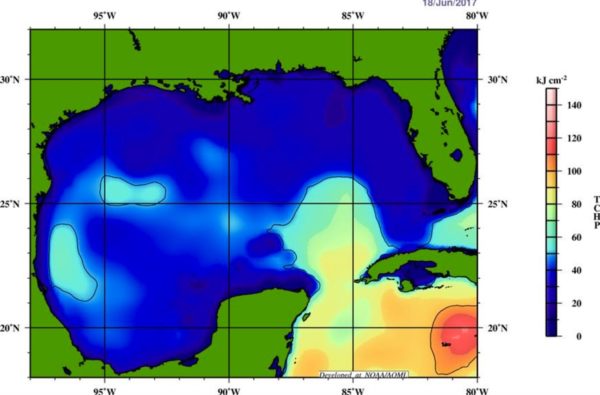
SEA SURFACE TEMPERATURES
Current sea surface temperatures throughout the Gulf of Mexico are running in the neighborhood of 27-28ºC (80-82ºF). That’s certainly above the 26C that tropical cyclones like to feed on, but the oceanic heat content is not that high, running less than 25 kj/cm2.
WPC THOUGHTS
The folks at the Weather Prediction Center have the low moving to near Houston Thursday morning, to near Natchez MS by Friday morning and Chattanooga by Saturday morning. That would be a favorable track for rain across Central Alabama.
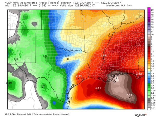
ALONG THE GULF COAST
The main impact from 93L will likely be very heavy rainfall along the Gulf Coast. Areas from the Alabama Coast to southeastern Louisiana are forecast by the WPC to have 7-9 inches of rain between now and the weekend. Squally weather will affect the coast as well, along with rip currents and rough surf. Tornadoes will be a problem to the east of where the center reaches the coast. We could be dealing with a few tornadoes here by Friday if some of the model tracks materialize.
RAIN FOR US
That same WPC forecast has us picking up 3-5 inches of rain in the I-59 Corridor, putting the drought further in our rear view mirror.
MODEL TRACKS
GFS Track: The latest GFS model run has the center of low pressure moving onshore in Louisiana just south of Morgan City around midnight on Thursday morning, and progressing to near Dumas, Arkansas at midnight on Friday morning, and to near Portsmouth, Ohio at midnight on Saturday.
EURO: Has the center moving onshore near Brownsville, Texas on Thursday, then moving into northern Mexico and staying close to the Rio Grande as it moves northwest on Friday and eventually into Saturday.
CANADIAN: The GEM model brings the system into Lake Charles LA near the TX/LA border by 12z (7 a.m. CDT Thursday morning and then tracks it to near Memphis and across North Alabama on Friday. This solution brings tremendous amounts of rain all along the Gulf Coast from the Florida Panhandle to southeastern Louisiana (9+ inch amounts). It spits out around 2-3 inches in the I-20 Corridor with greater amounts to the north and south.
RECON
The NHC has tasked the Air Force with flying two missions potentially into the Gulf disturbance. The first would be taking off around 1 p.m. CDT. We will be watching to see if this is going to happen.
About the Author (Author Profile)
Scott Martin is an operational meteorologist, professional graphic artist, musician, husband, and father. Not only is Scott a member of the National Weather Association, but he is also the Central Alabama Chapter of the NWA president. Scott is also the co-founder of Racecast Weather, which provides forecasts for many racing series across the USA. He also supplies forecasts for the BassMaster Elite Series events including the BassMaster Classic.Subscribe
If you enjoyed this article, subscribe to receive more just like it.


