Potential Tropical Cyclone Three Is Turning Our Weather Upside Down At Midday
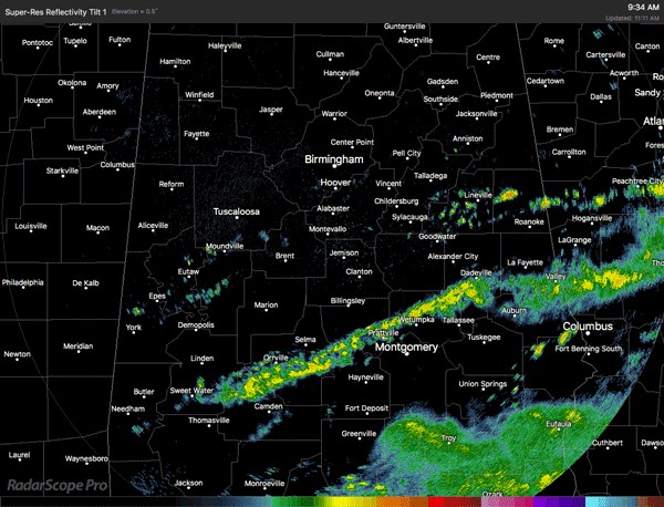
RADAR CHECK AT 11:00AM
The first feeder bands from Potential Tropical Cyclone Three have entered the southern parts of Central Alabama, with the firs band of rain located from Alexander City and Dadeville back to the southwest through Prattville and Selma, and exits the area to the southwest of Sweet Water. Movement with this band is mainly to the west, but there is a very slow jog to the north involved at PTC3 continues to move slowly northward.
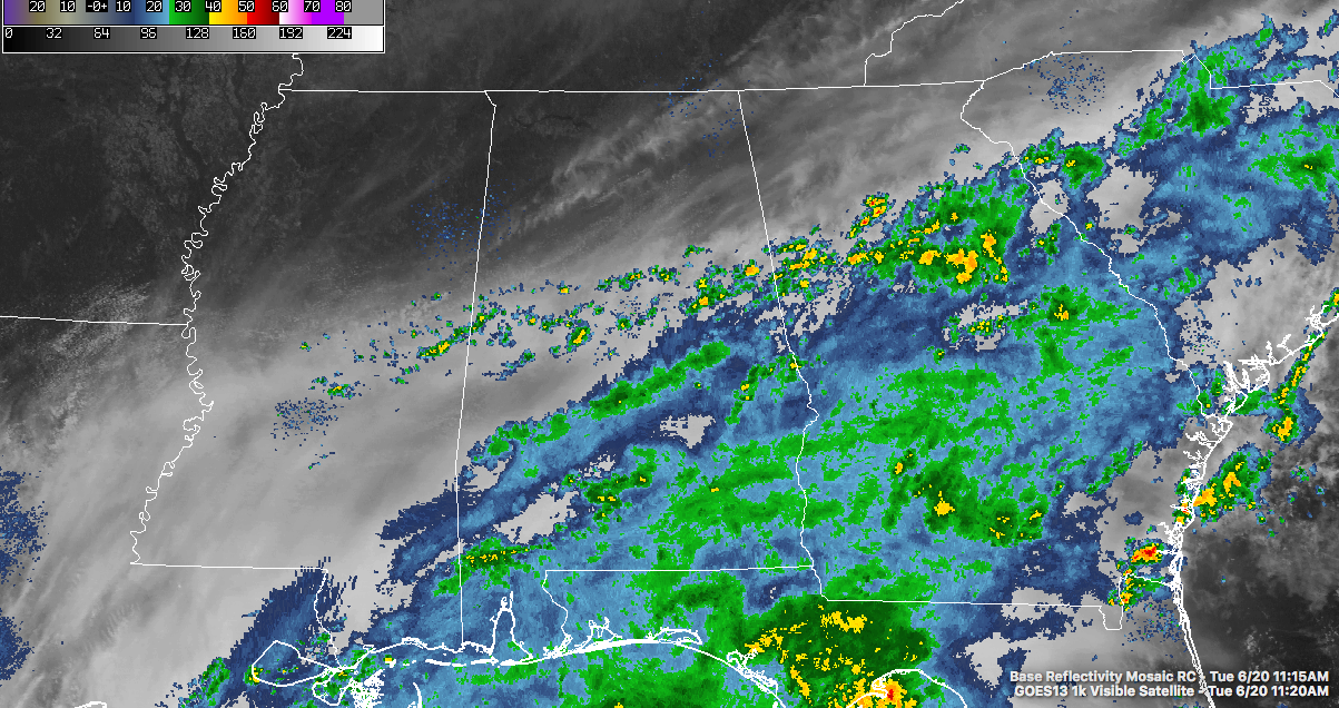
To the north of that, we have a broken line of showers and a few storms that has developed over the past hour or so, and these are mostly along the cold front that stalled out thanks to the inflow from PTC3. These are currently are along and south of a line from Aliceville to Hoover to Heflin. These are showing the same movement as the feeder band.
So for the rest of the day today, most of the heavier shower and thunderstorm activity associated with PTC3 will be mainly along and south of the I-20 and I-20/59 corridors, but there will be a risk for showers and storms north of that as well. Otherwise skies will be cloudy throughout the day, maybe with some peaks of sun shining through in the extreme northwestern parts of the area. Afternoon highs will be in the mid to the upper 70s in the south, with 80s to the north. We’ll still have a risk for scattered to numerous showers in the north, but widespread rain and storms will be likely in the south. Rainfall could be heavy at times, and the possibility is there for some localized flash flooding.
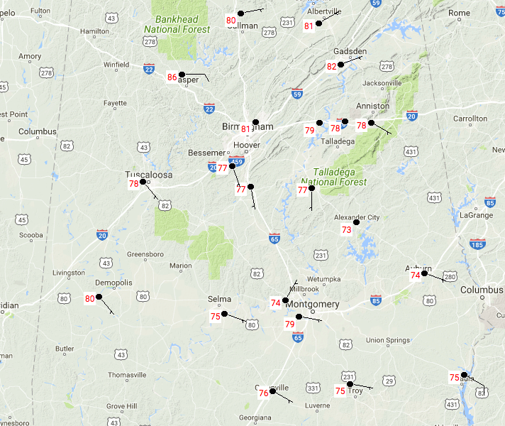
TEMPERATURES AT 11:00am
Temperatures across Central Alabama are currently running in the mid 70s to the lower 80s, with the cloud cover and showers from PTC3 causing the large discrepancies in the numbers to the south. Gadsden is currently the warm spot at 82 degrees, with Alexander City as the cool spot at 73 degrees.
MUCH OF THE SAME STORY FOR WEDNESDAY ACROSS THE AREA
Showers and storms from the feeder bands will mainly affect the southern two-thirds of Central Alabama throughout the day, while there will be a decent risk for scattered showers and storms to the north. Once again, rainfall could be heavy at times and localized flash flooding could be an issue. When it’s not raining, skies will be mostly cloudy to completely overcast. Afternoon highs are expected to be in the mid 70s to the mid 80s across the area from the south to the north (sounds strange because the temperature profile is usually reversed).
JUST A HEADS UP FOR THURSDAY AND FRIDAY
There will be an increase in instability during the heating of the day for the end of the week as the low gets closer to the area. Right now this is not 100% set in stone, but there is a possibility that a few brief tornadoes and damaging winds could be associated with stronger cells moving in the bands. Right now, the main risks for those will be along and west of the I-65 corridor.
A LOOK AT THE TROPICS
We have started the new Tropical Weather category on the blog, and that is where we will have the latest updates on Tropical Storm Bret and Potential Tropical Cyclone Three. It is located just below Alabama’s Weather on the main page of the site. The next set of updates from the National Hurricane Center will be out at 1PM today. Rainfall rates along the coast are already pretty impressive. Apalachicola has already received 2.62 inches, and rainfall rates from Ochlockonee Bay to the north through Sopchoppy expected to be 2-4 inches over the next hour alone.
HEADING TO THE BEACH
For a detailed look at the weather from Fort Morgan over to Panama City Beach, click here to see the AlabamaWx Beach Forecast Center page. The Beach Forecast is partially underwritten by the support of Brett/Robinson Vacation Rentals in Gulf Shores and Orange Beach. Click here to see Brett/Robinson’s Own Your Summer specials now!
TODAY IN WEATHER HISTORY
June 20, 1964 – A squall line producing large hail swept through central Illinois. A second squall line moved through during the early morning hours of the 21st, and a third one moved through shortly after dawn. The series of hailstorms caused nine million dollars damage. Hailstones as large as grapefruit caused heavy damage to trees, utility lines, crops and buildings. The thunderstorms also produced as much as five inches of rain in an eight hour period.
WEATHERBRAINS
This week, the panel entertained two satellite experts who talked about GOES-16. The show went nearly three hours! Don’t forget you can listen to our weekly 90 minute netcast anytime on the web, or on iTunes. This is the show all about weather featuring many familiar voices, including our meteorologists here at ABC 33/40. you can watch it live here on Monday nights at 8:30PM CDT.
Category: Alabama's Weather, ALL POSTS
About the Author (Author Profile)
Scott Martin is an operational meteorologist, professional graphic artist, musician, husband, and father. Not only is Scott a member of the National Weather Association, but he is also the Central Alabama Chapter of the NWA president. Scott is also the co-founder of Racecast Weather, which provides forecasts for many racing series across the USA. He also supplies forecasts for the BassMaster Elite Series events including the BassMaster Classic.Subscribe
If you enjoyed this article, subscribe to receive more just like it.


